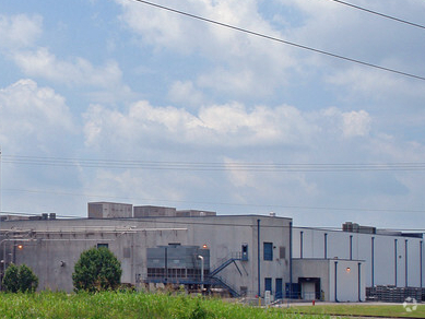
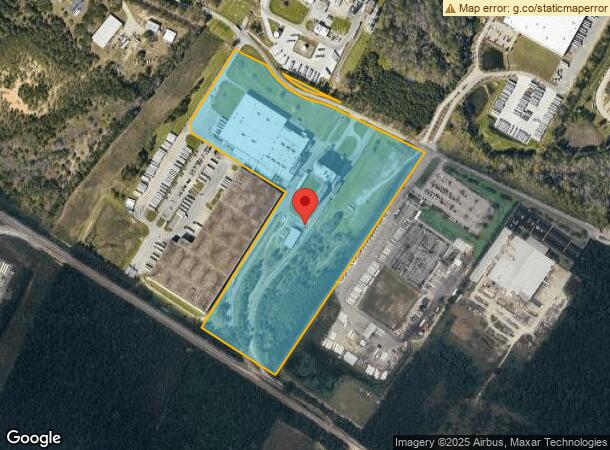
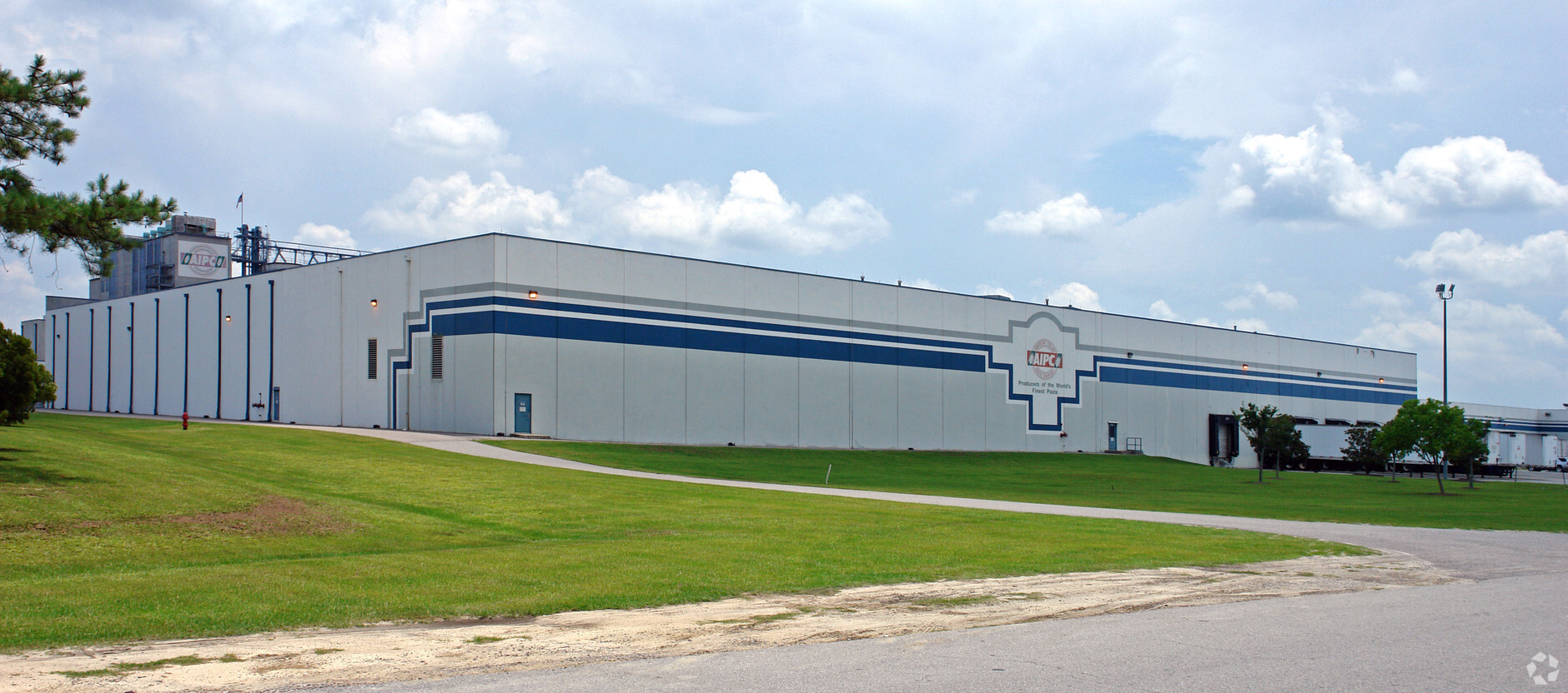
Property Record
2000 American Italian Way, Columbia, SC 29209
NEARBY LISTINGS FOR SALE OR LEASE
Property Detail
2000 American Italian Way
Columbia, SC
Garners Ferry
19000-05-03
#SU #PR 55-4834 56-964
Commercialnec
Richland
X
South Carolina
45079C0383L
34.55 AC
2024
Southeast Columbia
2023
Columbia
011702
DEMOGRAPHICS near 2000 American Italian Way
1 Mile
3 Mile
5 Mile
2024 Total Population
1,290
25,256
65,891
2029 Population
1,324
25,576
66,818
Pop Growth 2024-2029
+ 2.64%
+ 1.27%
+ 1.41%
Average Age
38
39
36
2024 Total Households
470
10,491
24,679
HH Growth 2024-2029
+ 2.77%
+ 1.32%
+ 1.56%
Median Household Inc
$52,307
$56,848
$55,090
Avg Household Size
2.30
2.30
2.30
2024 Avg HH Vehicles
2.00
2.00
2.00
Median Home Value
$150,349
$172,738
$184,402
Median Year Built
1986
1984
1982
Nearby Places
- Restaurants
- Banks
- Shops
- Fitness
- Groceries
PUBLIC TRANSPORTATION
COMMUTER RAIL
Columbia Amtrak Station (Silver Star - Amtrak)
DRIVE
WALK
Distance
Columbia Amtrak Station (Silver Star - Amtrak)
18 min
9.1 mi
AIRPORT
Columbia Metro
DRIVE
WALK
Distance
Columbia Metro
30 min
16.3 mi
Freight Ports
North Charleston Terminal
DRIVE
WALK
Distance
North Charleston Terminal
124 min
107.6 mi
Nearby Properties
Address
Land Use
TOTAL SIZE
Lot Size
Zoning
Address
Land Use
TOTAL SIZE
Lot Size
Zoning
241,878 SF
14.03 AC
C-3
Address
Land Use
TOTAL SIZE
Lot Size
Zoning
294,105 SF
19 AC
RG-2
Address
Land Use
TOTAL SIZE
Lot Size
Zoning
230,053 SF
18.35 AC
C-3
Address
Land Use
TOTAL SIZE
Lot Size
Zoning
212,787 SF
26.93 AC
C-3
Address
Land Use
TOTAL SIZE
Lot Size
Zoning
3,000 SF
52.49 AC
O-I
Address
Land Use
TOTAL SIZE
Lot Size
Zoning
281,304 SF
22.86 AC
RG-2
Address
Land Use
TOTAL SIZE
Lot Size
Zoning
247,744 SF
15.32 AC
RM-HD
Address
Land Use
TOTAL SIZE
Lot Size
Zoning
68,216 SF
1.84 AC
C-3
Address
Land Use
TOTAL SIZE
Lot Size
Zoning
255,848 SF
19.98 AC
RM-HD
Address
Land Use
TOTAL SIZE
Lot Size
Zoning
199,263 SF
18.29 AC
C-3
Address
Land Use
TOTAL SIZE
Lot Size
Zoning
160,954 SF
24.03 AC
C-3
Address
Land Use
TOTAL SIZE
Lot Size
Zoning
1,676 SF
8.03 AC
RG-2
Address
Land Use
TOTAL SIZE
Lot Size
Zoning
140,100 SF
7.12 AC
M-2
Address
Land Use
TOTAL SIZE
Lot Size
Zoning
297,892 SF
10.99 AC
M-2
Address
Land Use
TOTAL SIZE
Lot Size
Zoning
68,012 SF
13.18 AC
M-1
Address
Land Use
TOTAL SIZE
Lot Size
Zoning
180,828 SF
17.24 AC
RSF-3
Address
Land Use
TOTAL SIZE
Lot Size
Zoning
67,458 SF
2.36 AC
C-3
Address
Land Use
TOTAL SIZE
Lot Size
Zoning
26,427 SF
2.27 AC
PUD-C
Address
Land Use
TOTAL SIZE
Lot Size
Zoning
72,128 SF
4.95 AC
C-3
Address
Land Use
TOTAL SIZE
Lot Size
Zoning
32,640 SF
23.73 AC
RSF-2
Address
Land Use
TOTAL SIZE
Lot Size
Zoning
45,883 SF
5.11 AC
GC
Address
Land Use
TOTAL SIZE
Lot Size
Zoning
45,530 SF
4.72 AC
D-1
Address
Land Use
TOTAL SIZE
Lot Size
Zoning
194,172 SF
15.51 AC
GC
Address
Land Use
TOTAL SIZE
Lot Size
Zoning
402.10 AC
M-1
Address
Land Use
TOTAL SIZE
Lot Size
Zoning
114,660 SF
11.02 AC
RM-HD
Address
Land Use
TOTAL SIZE
Lot Size
Zoning
55,828 SF
2.68 AC
C-3
Address
Land Use
TOTAL SIZE
Lot Size
Zoning
75,034 SF
2.46 AC
GC
Address
Land Use
TOTAL SIZE
Lot Size
Zoning
102.68 AC
M-1
Address
Land Use
TOTAL SIZE
Lot Size
Zoning
60,772 SF
9.30 AC
GC
Address
Land Use
TOTAL SIZE
Lot Size
Zoning
125,976 SF
28.95 AC
M-1
The World's #1 Commercial Real Estate Marketplace
Connect with us
© 2025 CoStar Group
The information above has been obtained from sources believed reliable. While we do not doubt its accuracy we have not verified it and make no guarantee, warranty or representation about it. It is your responsibility to independently confirm its accuracy and completeness. Any projections, opinions, assumptions, or estimates used are for example only and do not represent the current or future performance of the property. The value of this transaction to you depends on tax and other factors which should be evaluated by your tax, financial, and legal advisors. You and your advisors should conduct a careful, independent investigation of the property to determine to your satisfaction the suitability of the property for your needs.