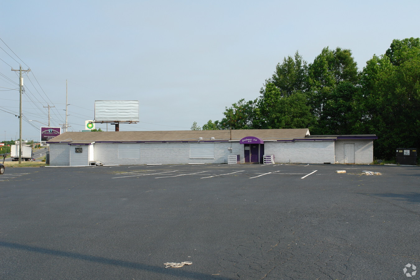
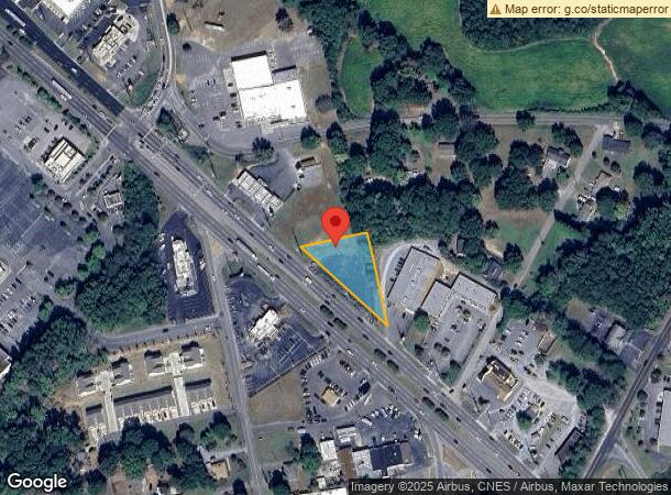
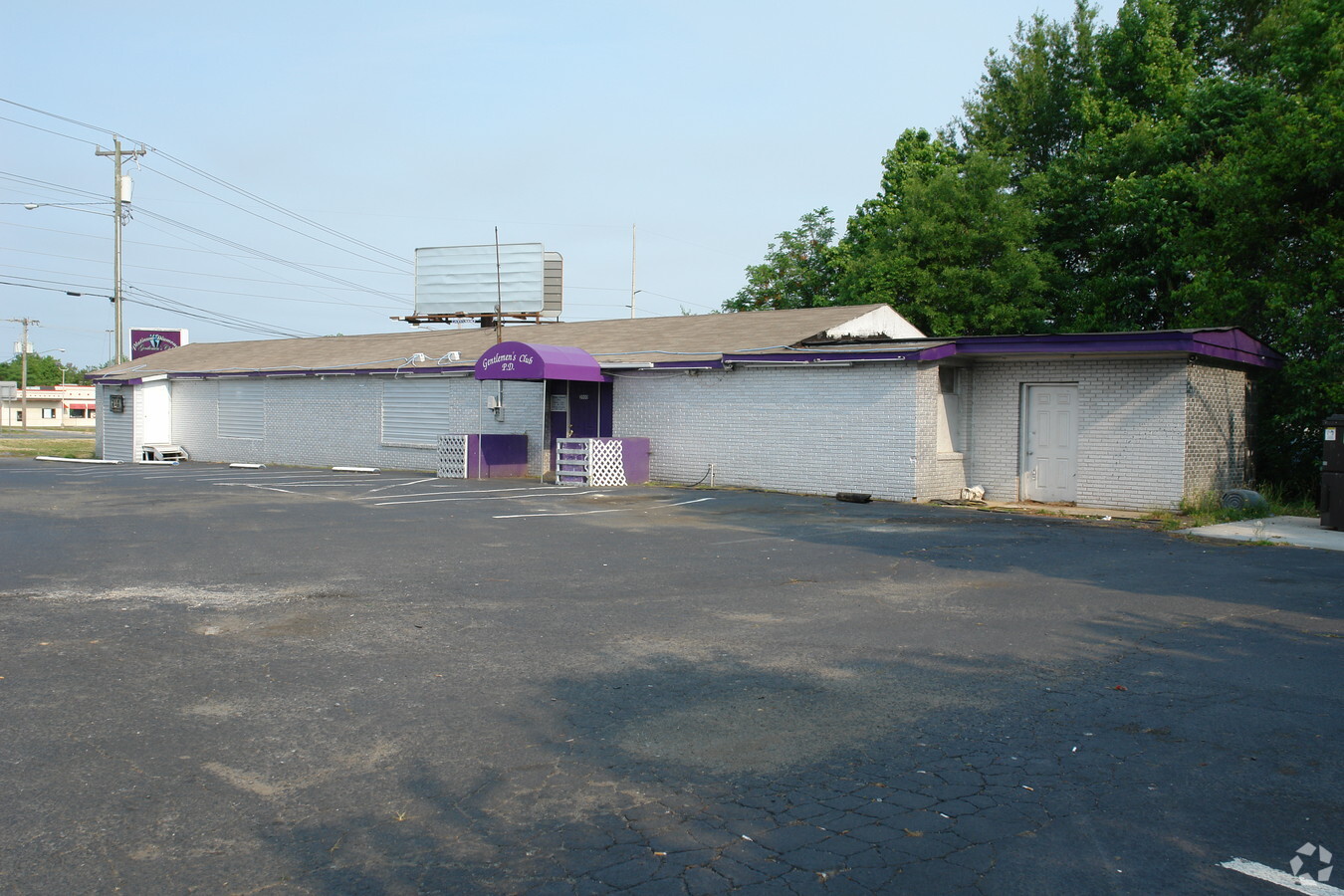
Property Record
2000 W Roosevelt Blvd, Monroe, NC 28110
NEARBY LISTINGS FOR SALE OR LEASE
Property Detail
2000 W Roosevelt Blvd
Charlotte-Concord-Gastonia, NC-SC
Wriston Lee 1-188
09-223-073-A
P/22 P/23 P/24 BENTON HEI
Commercialacreage
Union
X
North Carolina
3710543600J
0.64 AC
2024
Union County
2024
Charlotte
020401
DEMOGRAPHICS near 2000 W Roosevelt Blvd
1 Mile
3 Mile
5 Mile
2024 Total Population
4,123
30,224
51,580
2029 Population
4,694
34,042
58,160
Pop Growth 2024-2029
+ 13.85%
+ 12.63%
+ 12.76%
Average Age
36
38
39
2024 Total Households
1,442
10,824
18,288
HH Growth 2024-2029
+ 14.01%
+ 12.81%
+ 12.92%
Median Household Inc
$58,223
$57,696
$67,634
Avg Household Size
2.70
2.70
2.70
2024 Avg HH Vehicles
2.00
2.00
2.00
Median Home Value
$190,697
$236,831
$258,840
Median Year Built
1990
1987
1992
Nearby Places
- Restaurants
- Banks
- Shops
- Fitness
- Groceries
PUBLIC TRANSPORTATION
AIRPORT
Charlotte/Douglas International
DRIVE
WALK
Distance
Charlotte/Douglas International
47 min
30.7 mi
Concord-Padgett Regional
DRIVE
WALK
Distance
Concord-Padgett Regional
45 min
35.0 mi
Freight Ports
North Charleston Terminal
DRIVE
WALK
Distance
North Charleston Terminal
223 min
186.4 mi
Nearby Properties
Address
Land Use
TOTAL SIZE
Lot Size
Zoning
Address
Land Use
TOTAL SIZE
Lot Size
Zoning
78.48 AC
Address
Land Use
TOTAL SIZE
Lot Size
Zoning
148,145 SF
26.68 AC
G-I MONROE
Address
Land Use
TOTAL SIZE
Lot Size
Zoning
134,187 SF
32.44 AC
R-10 MONRO
Address
Land Use
TOTAL SIZE
Lot Size
Zoning
57,664 SF
45.15 AC
R-20 MONRO
Address
Land Use
TOTAL SIZE
Lot Size
Zoning
99,235 SF
1.92 AC
CBD MONROE
Address
Land Use
TOTAL SIZE
Lot Size
Zoning
71,831 SF
67.94 AC
CD MONROE
Address
Land Use
TOTAL SIZE
Lot Size
Zoning
82.26 AC
G-I MONROE
Address
Land Use
TOTAL SIZE
Lot Size
Zoning
81,504 SF
30.21 AC
CD MONROE
Address
Land Use
TOTAL SIZE
Lot Size
Zoning
35.14 AC
G-I MONROE
Address
Land Use
TOTAL SIZE
Lot Size
Zoning
219,625 SF
36.12 AC
GB MONROE
Address
Land Use
TOTAL SIZE
Lot Size
Zoning
14.77 AC
Address
Land Use
TOTAL SIZE
Lot Size
Zoning
30,708 SF
29.10 AC
R-MF MONRO
Address
Land Use
TOTAL SIZE
Lot Size
Zoning
79,493 SF
18.97 AC
CD MONROE
Address
Land Use
TOTAL SIZE
Lot Size
Zoning
54,712 SF
10.01 AC
GB MONROE
Address
Land Use
TOTAL SIZE
Lot Size
Zoning
40,291 SF
3.59 AC
CD MONROE
Address
Land Use
TOTAL SIZE
Lot Size
Zoning
123,296 SF
9.70 AC
CD MONROE
Address
Land Use
TOTAL SIZE
Lot Size
Zoning
65,122 SF
5.26 AC
R-10 MONRO
Address
Land Use
TOTAL SIZE
Lot Size
Zoning
5.89 AC
G-I MONROE
Address
Land Use
TOTAL SIZE
Lot Size
Zoning
101,035 SF
26.11 AC
G-I MONROE
Address
Land Use
TOTAL SIZE
Lot Size
Zoning
59,060 SF
7.51 AC
CD MONROE
Address
Land Use
TOTAL SIZE
Lot Size
Zoning
25.10 AC
RBD INDIAN
Address
Land Use
TOTAL SIZE
Lot Size
Zoning
22,944 SF
11.33 AC
GB MONROE
Address
Land Use
TOTAL SIZE
Lot Size
Zoning
62,865 SF
4.87 AC
CD MONROE
Address
Land Use
TOTAL SIZE
Lot Size
Zoning
136,370 SF
10.22 AC
GB MONROE
Address
Land Use
TOTAL SIZE
Lot Size
Zoning
18,208 SF
12.09 AC
R-MF MONRO
Address
Land Use
TOTAL SIZE
Lot Size
Zoning
6,440 SF
2.23 AC
GB MONROE
Address
Land Use
TOTAL SIZE
Lot Size
Zoning
32,872 SF
9.35 AC
Address
Land Use
TOTAL SIZE
Lot Size
Zoning
41,820 SF
6.23 AC
G-I MONROE
Address
Land Use
TOTAL SIZE
Lot Size
Zoning
32,815 SF
8.28 AC
R-20 MONRO
Address
Land Use
TOTAL SIZE
Lot Size
Zoning
32,670 SF
12.78 AC
GB MONROE
The World's #1 Commercial Real Estate Marketplace
Connect with us
© 2025 CoStar Group
The information above has been obtained from sources believed reliable. While we do not doubt its accuracy we have not verified it and make no guarantee, warranty or representation about it. It is your responsibility to independently confirm its accuracy and completeness. Any projections, opinions, assumptions, or estimates used are for example only and do not represent the current or future performance of the property. The value of this transaction to you depends on tax and other factors which should be evaluated by your tax, financial, and legal advisors. You and your advisors should conduct a careful, independent investigation of the property to determine to your satisfaction the suitability of the property for your needs.