Property Record
2009 Missouri Blvd, Jefferson City, MO 65109
NEARBY LISTINGS FOR SALE OR LEASE
-
-
View all Jefferson City listings for sale on LoopNet.com
Property Detail
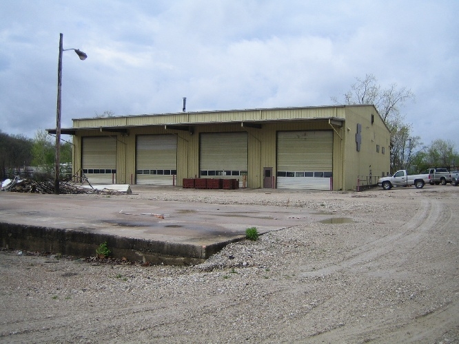
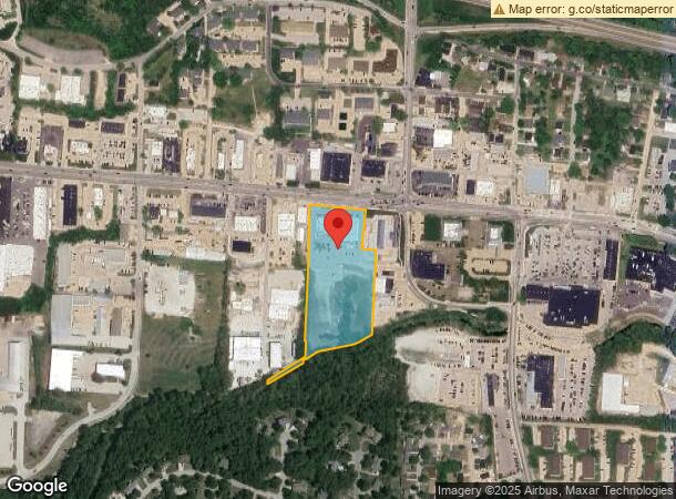
2009 Missouri Blvd
10-0.1-11-000-100-200-2
PT SENE; BEG SW COR INT MO BLVD & DIX RD; W 224 POB; W 308; S 845; S 235.2; S 7.01; NE 541.44; N 792.09;N 467.09; W 80; N
Storebuilding
Cole
AE
Missouri
29051C0129E
5.93 AC
2023
Other Market Areas
2024
Jefferson City, MO
010701
DEMOGRAPHICS near 2009 Missouri Blvd
1 Mile
3 Mile
5 Mile
2024 Total Population
6,724
33,049
54,389
2029 Population
6,609
32,653
53,603
Pop Growth 2024-2029
(1.71%)
(1.20%)
(1.45%)
Average Age
41
41
41
2024 Total Households
3,123
14,380
23,119
HH Growth 2024-2029
(1.92%)
(1.26%)
(1.57%)
Median Household Inc
$53,967
$53,075
$59,092
Avg Household Size
2.00
2.10
2.20
2024 Avg HH Vehicles
2.00
2.00
2.00
Median Home Value
$166,734
$172,131
$178,688
Median Year Built
1972
1972
1978
Nearby Places
- Restaurants
- Banks
- Shops
- Fitness
- Groceries
PUBLIC TRANSPORTATION
COMMUTER RAIL
Jefferson City Amtrak Station (Lincoln Service Missouri River Runner - Amtrak, Missouri River Runner - Amtrak)
DRIVE
WALK
Distance
Jefferson City Amtrak Station (Lincoln Service Missouri River Runner - Amtrak, Missouri River Runner - Amtrak)
5 min
2.4 mi
AIRPORT
Columbia Regional
DRIVE
WALK
Distance
Columbia Regional
28 min
22.1 mi
Freight Ports
Tulsa Port of Inola
DRIVE
WALK
Distance
Tulsa Port of Inola
346 min
306.3 mi
Nearby Properties
Address
Land Use
TOTAL SIZE
Lot Size
Zoning
Address
Land Use
TOTAL SIZE
Lot Size
Zoning
2.15 AC
C2
Address
Land Use
TOTAL SIZE
Lot Size
Zoning
7.07 AC
C1
Address
Land Use
TOTAL SIZE
Lot Size
Zoning
59.73 AC
M2
Address
Land Use
TOTAL SIZE
Lot Size
Zoning
14.92 AC
PUD
Address
Land Use
TOTAL SIZE
Lot Size
Zoning
0.63 AC
C3
Address
Land Use
TOTAL SIZE
Lot Size
Zoning
39.72 AC
M2
Address
Land Use
TOTAL SIZE
Lot Size
Zoning
4.25 AC
PUD
Address
Land Use
TOTAL SIZE
Lot Size
Zoning
13.23 AC
C2
Address
Land Use
TOTAL SIZE
Lot Size
Zoning
30.57 AC
C2
Address
Land Use
TOTAL SIZE
Lot Size
Zoning
643,216 SF
96.40 AC
Address
Land Use
TOTAL SIZE
Lot Size
Zoning
8.03 AC
PUD
Address
Land Use
TOTAL SIZE
Lot Size
Zoning
4.68 AC
C1
Address
Land Use
TOTAL SIZE
Lot Size
Zoning
18.43 AC
C2
Address
Land Use
TOTAL SIZE
Lot Size
Zoning
3.88 AC
PUD
Address
Land Use
TOTAL SIZE
Lot Size
Zoning
Address
Land Use
TOTAL SIZE
Lot Size
Zoning
1.82 AC
M2
Address
Land Use
TOTAL SIZE
Lot Size
Zoning
1.92 AC
C3
Address
Land Use
TOTAL SIZE
Lot Size
Zoning
0.38 AC
C3
Address
Land Use
TOTAL SIZE
Lot Size
Zoning
Address
Land Use
TOTAL SIZE
Lot Size
Zoning
24.55 AC
C2
Address
Land Use
TOTAL SIZE
Lot Size
Zoning
1.53 AC
C2
Address
Land Use
TOTAL SIZE
Lot Size
Zoning
4.62 AC
C2
Address
Land Use
TOTAL SIZE
Lot Size
Zoning
Address
Land Use
TOTAL SIZE
Lot Size
Zoning
2.84 AC
M1
Address
Land Use
TOTAL SIZE
Lot Size
Zoning
0.56 AC
C3
Address
Land Use
TOTAL SIZE
Lot Size
Zoning
11.52 AC
PUD
Address
Land Use
TOTAL SIZE
Lot Size
Zoning
20.46 AC
PUD
Address
Land Use
TOTAL SIZE
Lot Size
Zoning
0.94 AC
C1
Address
Land Use
TOTAL SIZE
Lot Size
Zoning
13.32 AC
C2
Address
Land Use
TOTAL SIZE
Lot Size
Zoning
6.45 AC
C2
The World's #1 Commercial Real Estate Marketplace
Connect with us
© 2025 CoStar Group
The information above has been obtained from sources believed reliable. While we do not doubt its accuracy we have not verified it and make no guarantee, warranty or representation about it. It is your responsibility to independently confirm its accuracy and completeness. Any projections, opinions, assumptions, or estimates used are for example only and do not represent the current or future performance of the property. The value of this transaction to you depends on tax and other factors which should be evaluated by your tax, financial, and legal advisors. You and your advisors should conduct a careful, independent investigation of the property to determine to your satisfaction the suitability of the property for your needs.