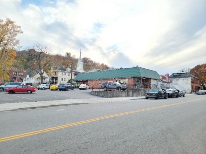
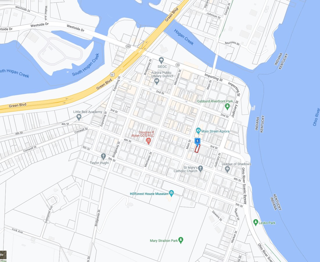
Property Record
201 3Rd St, Aurora, IN 47001
NEARBY LISTINGS FOR SALE OR LEASE
-
-
View all Aurora listings for sale on LoopNet.com
Property Detail
201 3Rd St
Cincinnati, OH-KY-IN
Aurora Original Plat Sub
15-07-32-103-098.000-003
09-178 AURORA LOT 115, 116, 117EPT 32-5-1 STRIP OF GROUND 35' 10" & 18FT VACATED ALLEY BETWEEN LOTS 116 & 117 ALSO: 15-07-32-
Supermarket
Dearborn
AE
Indiana
21015C0070D
115-117
2023
0.37 AC
2023
Dearborn County
080500
Cincinnati/Dayton
10,011 SF
DEMOGRAPHICS near 201 3Rd St
1 Mile
3 Mile
5 Mile
2024 Total Population
2,426
6,477
18,488
2029 Population
2,526
6,708
19,155
Pop Growth 2024-2029
+ 4.12%
+ 3.57%
+ 3.61%
Average Age
40
41
41
2024 Total Households
995
2,598
7,462
HH Growth 2024-2029
+ 4.12%
+ 3.58%
+ 3.67%
Median Household Inc
$38,365
$53,333
$59,037
Avg Household Size
2.40
2.40
2.40
2024 Avg HH Vehicles
2.00
2.00
2.00
Median Home Value
$141,777
$163,953
$165,217
Median Year Built
1948
1959
1969
Nearby Places
- Restaurants
- Banks
- Shops
- Fitness
- Groceries
PUBLIC TRANSPORTATION
AIRPORT
Cincinnati/Northern Kentucky International
DRIVE
WALK
Distance
Cincinnati/Northern Kentucky International
41 min
23.1 mi
Freight Ports
Port of Toledo
DRIVE
WALK
Distance
Port of Toledo
267 min
225.2 mi
SALE & LEASE HISTORY
LISTING DATE
SALE/LEASE

Jan 03, 2023
For Sale
Nearby Properties
Address
Land Use
TOTAL SIZE
Lot Size
Zoning
Address
Land Use
TOTAL SIZE
Lot Size
Zoning
205,455 SF
20.32 AC
Address
Land Use
TOTAL SIZE
Lot Size
Zoning
111,861 SF
11.72 AC
Address
Land Use
TOTAL SIZE
Lot Size
Zoning
68,146 SF
7.06 AC
Address
Land Use
TOTAL SIZE
Lot Size
Zoning
1,392 SF
78 AC
Address
Land Use
TOTAL SIZE
Lot Size
Zoning
94,974 SF
8.06 AC
Address
Land Use
TOTAL SIZE
Lot Size
Zoning
242.80 AC
Address
Land Use
TOTAL SIZE
Lot Size
Zoning
2,853 SF
9 AC
Address
Land Use
TOTAL SIZE
Lot Size
Zoning
13,136 SF
2.42 AC
Address
Land Use
TOTAL SIZE
Lot Size
Zoning
24,496 SF
4.50 AC
Address
Land Use
TOTAL SIZE
Lot Size
Zoning
26,500 SF
14.36 AC
Address
Land Use
TOTAL SIZE
Lot Size
Zoning
5,600 SF
132.85 AC
Address
Land Use
TOTAL SIZE
Lot Size
Zoning
119.30 AC
Address
Land Use
TOTAL SIZE
Lot Size
Zoning
50,816 SF
4.68 AC
Address
Land Use
TOTAL SIZE
Lot Size
Zoning
7,180 SF
16 AC
Address
Land Use
TOTAL SIZE
Lot Size
Zoning
4.86 AC
Address
Land Use
TOTAL SIZE
Lot Size
Zoning
3,200 SF
12.46 AC
Address
Land Use
TOTAL SIZE
Lot Size
Zoning
154.79 AC
Address
Land Use
TOTAL SIZE
Lot Size
Zoning
2,349 SF
100.32 AC
Address
Land Use
TOTAL SIZE
Lot Size
Zoning
15,212 SF
3.07 AC
Address
Land Use
TOTAL SIZE
Lot Size
Zoning
24,209 SF
2.05 AC
Address
Land Use
TOTAL SIZE
Lot Size
Zoning
1,696 SF
132.80 AC
Address
Land Use
TOTAL SIZE
Lot Size
Zoning
1,288 SF
131.28 AC
Address
Land Use
TOTAL SIZE
Lot Size
Zoning
2,280 SF
177.96 AC
Address
Land Use
TOTAL SIZE
Lot Size
Zoning
4,393 SF
1.74 AC
Address
Land Use
TOTAL SIZE
Lot Size
Zoning
Address
Land Use
TOTAL SIZE
Lot Size
Zoning
20,520 SF
5.40 AC
Address
Land Use
TOTAL SIZE
Lot Size
Zoning
15,000 SF
5.75 AC
Address
Land Use
TOTAL SIZE
Lot Size
Zoning
10,125 SF
1.41 AC
Address
Land Use
TOTAL SIZE
Lot Size
Zoning
4,875 SF
1.36 AC
Address
Land Use
TOTAL SIZE
Lot Size
Zoning
19,952 SF
1.50 AC
The World's #1 Commercial Real Estate Marketplace
Connect with us
© 2025 CoStar Group
The information above has been obtained from sources believed reliable. While we do not doubt its accuracy we have not verified it and make no guarantee, warranty or representation about it. It is your responsibility to independently confirm its accuracy and completeness. Any projections, opinions, assumptions, or estimates used are for example only and do not represent the current or future performance of the property. The value of this transaction to you depends on tax and other factors which should be evaluated by your tax, financial, and legal advisors. You and your advisors should conduct a careful, independent investigation of the property to determine to your satisfaction the suitability of the property for your needs.