Property Record
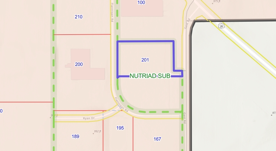
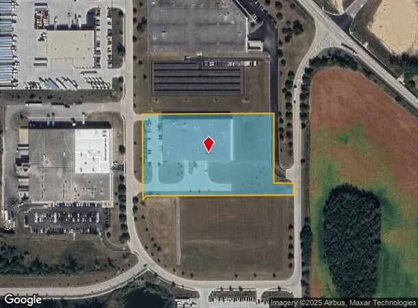
201 Flannigan Rd, Hampshire, IL 60140
NEARBY LISTINGS FOR SALE OR LEASE
Property Detail
201 Flannigan Rd
Chicago-Naperville-Elgin, IL-IN-WI
Nutriad Sub
01-11-180-001
NUTRIAD SUB LT 1
Industrialgeneral
Kane
X
Illinois
17089C0020J
1
2023
4.64 AC
2023
North Kane/I-90
850706
Chicago
DEMOGRAPHICS near 201 Flannigan Rd
1 Mile
3 Mile
5 Mile
2024 Total Population
2
11,648
33,538
2029 Population
2
11,571
33,452
Pop Growth 2024-2029
0.00%
(0.66%)
(0.26%)
Average Age
0
57
48
2024 Total Households
1
5,641
14,039
HH Growth 2024-2029
0.00%
(0.69%)
(0.28%)
Median Household Inc
$0
$71,440
$85,237
Avg Household Size
.00
2.00
2.40
2024 Avg HH Vehicles
1.00
2.00
2.00
Median Home Value
$0
$303,733
$313,274
Median Year Built
2005
2003
2003
Nearby Places
- Restaurants
- Banks
- Shops
- Fitness
- Groceries
Nearby Properties
Address
Land Use
TOTAL SIZE
Lot Size
Zoning
Address
Land Use
TOTAL SIZE
Lot Size
Zoning
8.48 AC
Address
Land Use
TOTAL SIZE
Lot Size
Zoning
Address
Land Use
TOTAL SIZE
Lot Size
Zoning
33.27 AC
Address
Land Use
TOTAL SIZE
Lot Size
Zoning
193,200 SF
23.60 AC
M2 MANUFAC
Address
Land Use
TOTAL SIZE
Lot Size
Zoning
13.24 AC
Address
Land Use
TOTAL SIZE
Lot Size
Zoning
89,940 SF
8.93 AC
Address
Land Use
TOTAL SIZE
Lot Size
Zoning
14.26 AC
Address
Land Use
TOTAL SIZE
Lot Size
Zoning
76,458 SF
6.67 AC
M2 MANUFAC
Address
Land Use
TOTAL SIZE
Lot Size
Zoning
152,275 SF
12.22 AC
I DISTRICT
Address
Land Use
TOTAL SIZE
Lot Size
Zoning
Address
Land Use
TOTAL SIZE
Lot Size
Zoning
44,800 SF
35.39 AC
M2 MANUFAC
Address
Land Use
TOTAL SIZE
Lot Size
Zoning
105,030 SF
10.53 AC
O-M OFFICE
Address
Land Use
TOTAL SIZE
Lot Size
Zoning
41,122 SF
4.25 AC
Address
Land Use
TOTAL SIZE
Lot Size
Zoning
141,588 SF
6.88 AC
Address
Land Use
TOTAL SIZE
Lot Size
Zoning
5.50 AC
O-M OFFICE
Address
Land Use
TOTAL SIZE
Lot Size
Zoning
10.30 AC
Address
Land Use
TOTAL SIZE
Lot Size
Zoning
Address
Land Use
TOTAL SIZE
Lot Size
Zoning
19,328 SF
15.27 AC
B1 DISTRIC
Address
Land Use
TOTAL SIZE
Lot Size
Zoning
Address
Land Use
TOTAL SIZE
Lot Size
Zoning
2.80 AC
Address
Land Use
TOTAL SIZE
Lot Size
Zoning
6,244 SF
3.21 AC
B1 DISTRIC
Address
Land Use
TOTAL SIZE
Lot Size
Zoning
162,846 SF
4.71 AC
Address
Land Use
TOTAL SIZE
Lot Size
Zoning
28,900 SF
9 AC
I DISTRICT
Address
Land Use
TOTAL SIZE
Lot Size
Zoning
23,626 SF
1.98 AC
I DISTRICT
Address
Land Use
TOTAL SIZE
Lot Size
Zoning
4.83 AC
Address
Land Use
TOTAL SIZE
Lot Size
Zoning
0.50 AC
Address
Land Use
TOTAL SIZE
Lot Size
Zoning
46,596 SF
5.66 AC
M1 MANUFAC
Address
Land Use
TOTAL SIZE
Lot Size
Zoning
29,863 SF
3.27 AC
I DISTRICT
Address
Land Use
TOTAL SIZE
Lot Size
Zoning
30,607 SF
2.36 AC
B1 DISTRIC
The World's #1 Commercial Real Estate Marketplace
Connect with us
© 2025 CoStar Group
The information above has been obtained from sources believed reliable. While we do not doubt its accuracy we have not verified it and make no guarantee, warranty or representation about it. It is your responsibility to independently confirm its accuracy and completeness. Any projections, opinions, assumptions, or estimates used are for example only and do not represent the current or future performance of the property. The value of this transaction to you depends on tax and other factors which should be evaluated by your tax, financial, and legal advisors. You and your advisors should conduct a careful, independent investigation of the property to determine to your satisfaction the suitability of the property for your needs.