Property Record
201 Learner Ln, Blairs, VA 24527
NEARBY LISTINGS FOR SALE OR LEASE
-
-
View all Blairs listings for sale on LoopNet.com
Property Detail
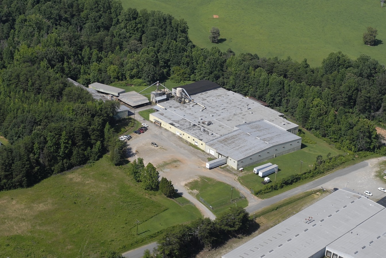
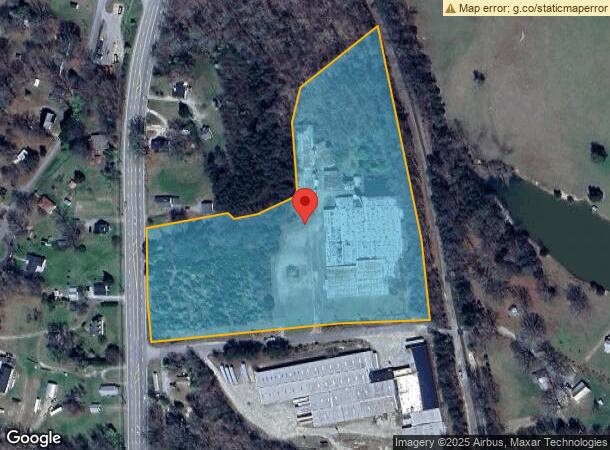
201 Learner Ln
2420-66-9558
U S HWY 29 11.14 AC DB417-505
Industrialgeneral
Pittsylvania
X
Virginia
51143C0536E
11.14 AC
2024
Virginia South Central
2024
Other Market Areas
011400
Danville, VA
DEMOGRAPHICS near 201 Learner Ln
1 Mile
3 Mile
5 Mile
2024 Total Population
1,051
7,594
23,313
2029 Population
1,037
7,444
22,871
Pop Growth 2024-2029
(1.33%)
(1.98%)
(1.90%)
Average Age
44
43
43
2024 Total Households
437
3,128
9,884
HH Growth 2024-2029
(1.37%)
(2.01%)
(1.91%)
Median Household Inc
$61,981
$58,258
$45,850
Avg Household Size
2.40
2.40
2.30
2024 Avg HH Vehicles
2.00
2.00
2.00
Median Home Value
$147,916
$156,416
$134,701
Median Year Built
1978
1983
1974
Nearby Places
- Restaurants
- Banks
- Shops
- Fitness
- Groceries
PUBLIC TRANSPORTATION
COMMUTER RAIL
Danville Amtrak Station (Crescent - Amtrak)
DRIVE
WALK
Distance
Danville Amtrak Station (Crescent - Amtrak)
11 min
7.1 mi
Freight Ports
Virginia Port Authority - Richmond
DRIVE
WALK
Distance
Virginia Port Authority - Richmond
194 min
146.9 mi
Nearby Properties
Address
Land Use
TOTAL SIZE
Lot Size
Zoning
Address
Land Use
TOTAL SIZE
Lot Size
Zoning
12.20 AC
B-2
Address
Land Use
TOTAL SIZE
Lot Size
Zoning
2,516 SF
19.75 AC
DZ
Address
Land Use
TOTAL SIZE
Lot Size
Zoning
75,816 SF
7.04 AC
COND MULTI
Address
Land Use
TOTAL SIZE
Lot Size
Zoning
73,290 SF
5.94 AC
RMF
Address
Land Use
TOTAL SIZE
Lot Size
Zoning
9,200 SF
5.41 AC
R-1
Address
Land Use
TOTAL SIZE
Lot Size
Zoning
20.17 AC
M-1
Address
Land Use
TOTAL SIZE
Lot Size
Zoning
21.40 AC
A-1
Address
Land Use
TOTAL SIZE
Lot Size
Zoning
40,000 SF
4.39 AC
B-2
Address
Land Use
TOTAL SIZE
Lot Size
Zoning
8.52 AC
B-2
Address
Land Use
TOTAL SIZE
Lot Size
Zoning
34,653 SF
8.87 AC
NEIGHBORHO
Address
Land Use
TOTAL SIZE
Lot Size
Zoning
2,788 SF
5.38 AC
RMF
Address
Land Use
TOTAL SIZE
Lot Size
Zoning
4.08 AC
B-2
Address
Land Use
TOTAL SIZE
Lot Size
Zoning
129,864 SF
14.35 AC
M-1
Address
Land Use
TOTAL SIZE
Lot Size
Zoning
23,046 SF
1.38 AC
OLD TOWN R
Address
Land Use
TOTAL SIZE
Lot Size
Zoning
9,728 SF
3.45 AC
M-1
Address
Land Use
TOTAL SIZE
Lot Size
Zoning
41,490 SF
2.91 AC
HIGHWAY RE
Address
Land Use
TOTAL SIZE
Lot Size
Zoning
5,980 SF
2.58 AC
B-2
Address
Land Use
TOTAL SIZE
Lot Size
Zoning
2,128 SF
9.59 AC
B-2
Address
Land Use
TOTAL SIZE
Lot Size
Zoning
8,586 SF
4.15 AC
B-2
Address
Land Use
TOTAL SIZE
Lot Size
Zoning
20,412 SF
5.14 AC
B-2
Address
Land Use
TOTAL SIZE
Lot Size
Zoning
5,194 SF
2.80 AC
B-2
Address
Land Use
TOTAL SIZE
Lot Size
Zoning
9,140 SF
7 AC
R-1
Address
Land Use
TOTAL SIZE
Lot Size
Zoning
97,425 SF
10 AC
M-1
Address
Land Use
TOTAL SIZE
Lot Size
Zoning
8,000 SF
1.15 AC
B-2
Address
Land Use
TOTAL SIZE
Lot Size
Zoning
1.61 AC
RMF
Address
Land Use
TOTAL SIZE
Lot Size
Zoning
8,320 SF
2.36 AC
B-2
Address
Land Use
TOTAL SIZE
Lot Size
Zoning
10,936 SF
3.37 AC
R-1
Address
Land Use
TOTAL SIZE
Lot Size
Zoning
9,504 SF
0.99 AC
B-1
Address
Land Use
TOTAL SIZE
Lot Size
Zoning
9,401 SF
2.49 AC
R-1
The World's #1 Commercial Real Estate Marketplace
Connect with us
© 2025 CoStar Group
The information above has been obtained from sources believed reliable. While we do not doubt its accuracy we have not verified it and make no guarantee, warranty or representation about it. It is your responsibility to independently confirm its accuracy and completeness. Any projections, opinions, assumptions, or estimates used are for example only and do not represent the current or future performance of the property. The value of this transaction to you depends on tax and other factors which should be evaluated by your tax, financial, and legal advisors. You and your advisors should conduct a careful, independent investigation of the property to determine to your satisfaction the suitability of the property for your needs.