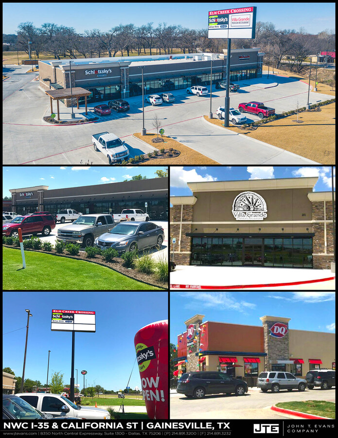
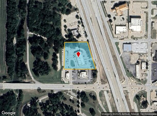
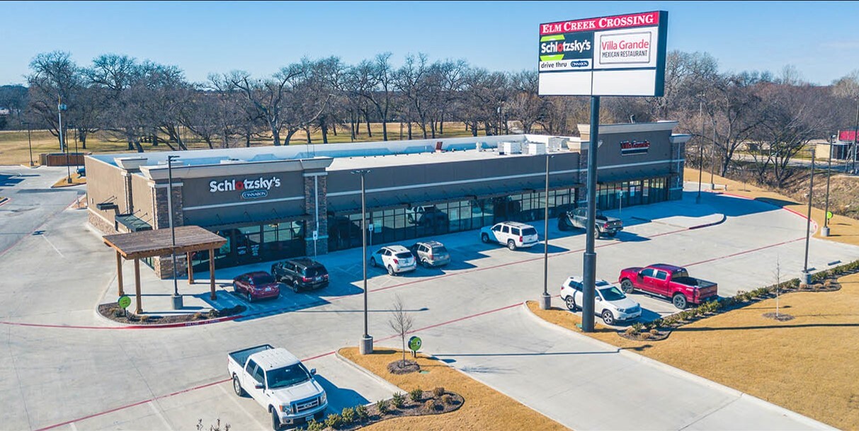
Property Record
201 N Interstate 35, Gainesville, TX 76240
NEARBY LISTINGS FOR SALE OR LEASE
Property Detail
201 N Interstate 35
Gainesville, TX
Moffett Park Addn
149717
MOFFETT PARK ADDN; LOT 1A
Storebuilding
Cooke
X
Texas
48097C0295C
1a
2023
2.66 AC
2024
Texas East Area
000400
Other Market Areas
14,400 SF
DEMOGRAPHICS near 201 N Interstate 35
1 Mile
3 Mile
5 Mile
2024 Total Population
5,169
19,768
22,670
2029 Population
5,646
21,440
24,476
Pop Growth 2024-2029
+ 9.23%
+ 8.46%
+ 7.97%
Average Age
37
37
38
2024 Total Households
1,908
7,266
8,339
HH Growth 2024-2029
+ 9.43%
+ 8.70%
+ 8.21%
Median Household Inc
$44,778
$47,410
$48,728
Avg Household Size
2.60
2.60
2.60
2024 Avg HH Vehicles
2.00
2.00
2.00
Median Home Value
$112,325
$129,309
$141,941
Median Year Built
1958
1971
1973
Nearby Places
- Restaurants
- Banks
- Shops
- Fitness
- Groceries
PUBLIC TRANSPORTATION
COMMUTER RAIL
Gainesville Amtrak Station (Heartland Flyer - Amtrak)
DRIVE
WALK
Distance
Gainesville Amtrak Station (Heartland Flyer - Amtrak)
2 min
17 min
0.9 mi
Freight Ports
Tulsa Port of Inola
DRIVE
WALK
Distance
Tulsa Port of Inola
278 min
243.5 mi
SALE & LEASE HISTORY
LISTING DATE
SALE/LEASE

Nov 02, 2023
For Sale
Nearby Properties
Address
Land Use
TOTAL SIZE
Lot Size
Zoning
Address
Land Use
TOTAL SIZE
Lot Size
Zoning
121,605 SF
Address
Land Use
TOTAL SIZE
Lot Size
Zoning
78,598 SF
2.90 AC
Address
Land Use
TOTAL SIZE
Lot Size
Zoning
133,708 SF
47.68 AC
Address
Land Use
TOTAL SIZE
Lot Size
Zoning
58,770 SF
26.40 AC
Address
Land Use
TOTAL SIZE
Lot Size
Zoning
402,800 SF
Address
Land Use
TOTAL SIZE
Lot Size
Zoning
6,939 SF
10.58 AC
Address
Land Use
TOTAL SIZE
Lot Size
Zoning
208,499 SF
33.91 AC
Address
Land Use
TOTAL SIZE
Lot Size
Zoning
46,927 SF
2.50 AC
Address
Land Use
TOTAL SIZE
Lot Size
Zoning
116,474 SF
10.60 AC
Address
Land Use
TOTAL SIZE
Lot Size
Zoning
63,038 SF
30 AC
Address
Land Use
TOTAL SIZE
Lot Size
Zoning
2,694 SF
7.31 AC
Address
Land Use
TOTAL SIZE
Lot Size
Zoning
20,818 SF
3.92 AC
Address
Land Use
TOTAL SIZE
Lot Size
Zoning
11,096 SF
2.59 AC
Address
Land Use
TOTAL SIZE
Lot Size
Zoning
41,472 SF
1.67 AC
Address
Land Use
TOTAL SIZE
Lot Size
Zoning
126,570 SF
27.93 AC
Address
Land Use
TOTAL SIZE
Lot Size
Zoning
135,760 SF
13.51 AC
Address
Land Use
TOTAL SIZE
Lot Size
Zoning
60,254 SF
1.76 AC
Address
Land Use
TOTAL SIZE
Lot Size
Zoning
108,208 SF
7.49 AC
Address
Land Use
TOTAL SIZE
Lot Size
Zoning
18,082 SF
6.81 AC
Address
Land Use
TOTAL SIZE
Lot Size
Zoning
53,032 SF
1.61 AC
Address
Land Use
TOTAL SIZE
Lot Size
Zoning
Address
Land Use
TOTAL SIZE
Lot Size
Zoning
70,076 SF
19.20 AC
Address
Land Use
TOTAL SIZE
Lot Size
Zoning
136,488 SF
30 AC
Address
Land Use
TOTAL SIZE
Lot Size
Zoning
364.40 AC
Address
Land Use
TOTAL SIZE
Lot Size
Zoning
96,450 SF
12.06 AC
Address
Land Use
TOTAL SIZE
Lot Size
Zoning
19,350 SF
1.68 AC
Address
Land Use
TOTAL SIZE
Lot Size
Zoning
11,880 SF
3 AC
Address
Land Use
TOTAL SIZE
Lot Size
Zoning
76,290 SF
48.27 AC
Address
Land Use
TOTAL SIZE
Lot Size
Zoning
58,100 SF
26.05 AC
The World's #1 Commercial Real Estate Marketplace
Connect with us
© 2025 CoStar Group
The information above has been obtained from sources believed reliable. While we do not doubt its accuracy we have not verified it and make no guarantee, warranty or representation about it. It is your responsibility to independently confirm its accuracy and completeness. Any projections, opinions, assumptions, or estimates used are for example only and do not represent the current or future performance of the property. The value of this transaction to you depends on tax and other factors which should be evaluated by your tax, financial, and legal advisors. You and your advisors should conduct a careful, independent investigation of the property to determine to your satisfaction the suitability of the property for your needs.