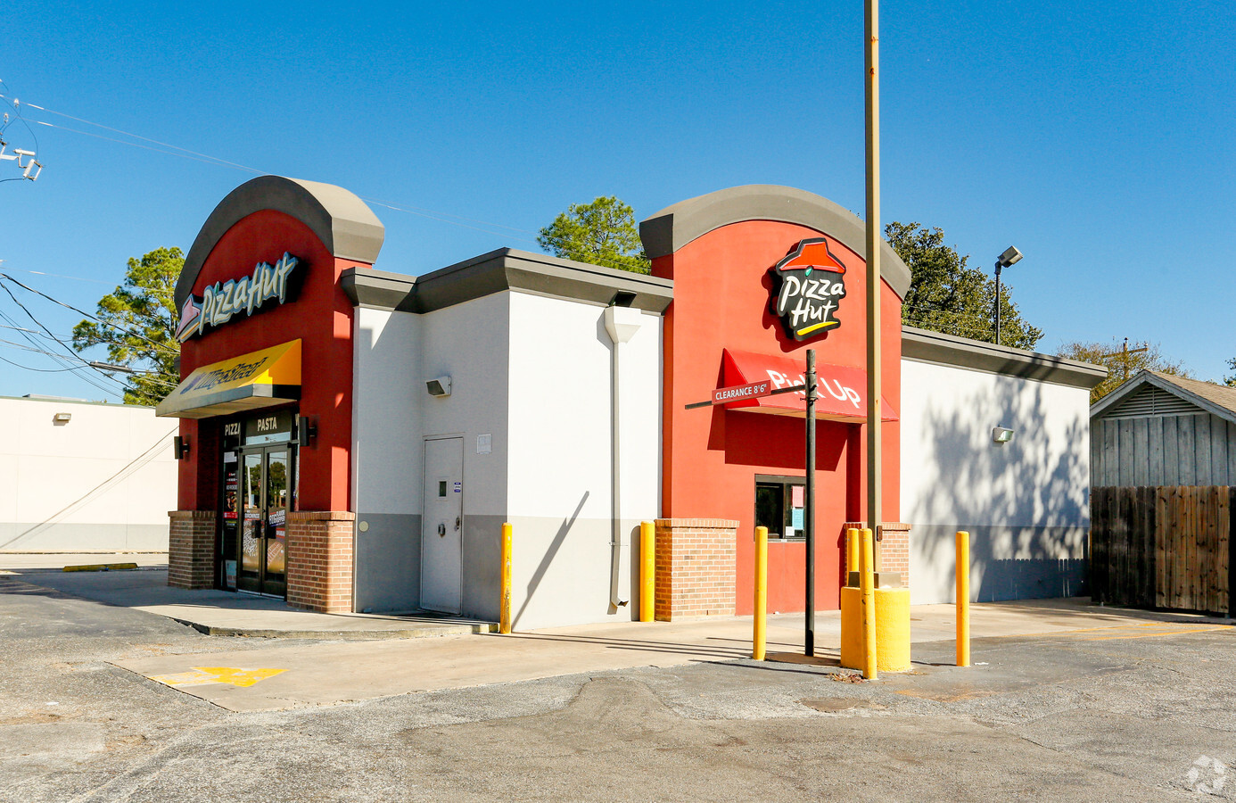
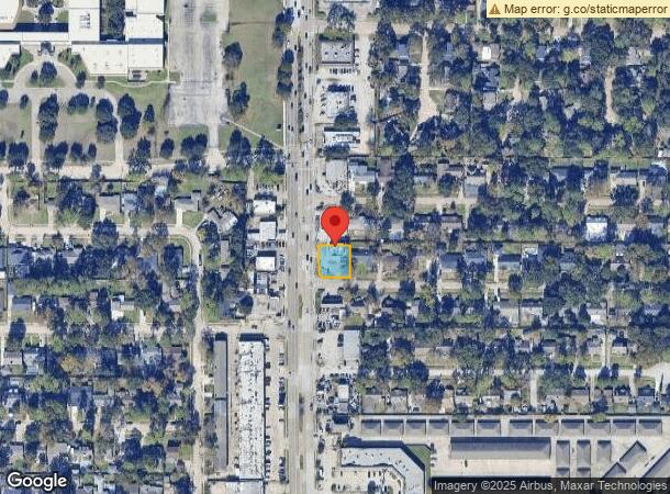
Property Record
2018 Gessner Rd, Houston, TX 77080


NEARBY LISTINGS FOR SALE OR LEASE
-
-
-
-
-
-
No Photo
-
-
View all Houston listings for sale on LoopNet.com
Property Detail
2018 Gessner Rd
0882990000026
Gessner Grove 2Nd R/P
Restaurantdrivein
TR 26A BLK 2 GESSNER GROVE 2ND R/P
X
Harris
48201C0645L
Texas
2023
0.22 AC
2023
Near NW Spring Valley
522201
Houston
1,708 SF
Houston-The Woodlands-Sugar Land, TX
DEMOGRAPHICS near 2018 Gessner Rd
1 Mile
3 Mile
5 Mile
2024 Total Population
19,007
124,629
293,194
2029 Population
19,320
128,448
301,394
Pop Growth 2024-2029
+ 1.65%
+ 3.06%
+ 2.80%
Average Age
37
37
38
2024 Total Households
6,632
45,832
113,295
HH Growth 2024-2029
+ 1.54%
+ 3.20%
+ 2.82%
Median Household Inc
$68,322
$66,869
$68,197
Avg Household Size
2.80
2.60
2.50
2024 Avg HH Vehicles
2.00
2.00
2.00
Median Home Value
$315,612
$360,217
$396,351
Median Year Built
1968
1976
1978
Nearby Places
- Restaurants
- Banks
- Shops
- Fitness
- Groceries
PUBLIC TRANSPORTATION
AIRPORT
William P Hobby
DRIVE
WALK
Distance
William P Hobby
41 min
26.3 mi
George Bush Intcntl/Houston
DRIVE
WALK
Distance
George Bush Intcntl/Houston
32 min
26.4 mi
Freight Ports
Port of Houston
DRIVE
WALK
Distance
Port of Houston
35 min
23.0 mi
SALE & LEASE HISTORY
LISTING DATE
SALE/LEASE

Jun 16, 2022
For Sale
Nearby Properties
Address
Land Use
TOTAL SIZE
Lot Size
Zoning
Address
Land Use
TOTAL SIZE
Lot Size
Zoning
935,613 SF
27.92 AC
Address
Land Use
TOTAL SIZE
Lot Size
Zoning
955,731 SF
3.40 AC
Address
Land Use
TOTAL SIZE
Lot Size
Zoning
797,516 SF
2.91 AC
Address
Land Use
TOTAL SIZE
Lot Size
Zoning
730,107 SF
2.57 AC
Address
Land Use
TOTAL SIZE
Lot Size
Zoning
743,954 SF
2.97 AC
Address
Land Use
TOTAL SIZE
Lot Size
Zoning
542,880 SF
1.22 AC
Address
Land Use
TOTAL SIZE
Lot Size
Zoning
487,073 SF
44.12 AC
Address
Land Use
TOTAL SIZE
Lot Size
Zoning
483,619 SF
32.81 AC
Address
Land Use
TOTAL SIZE
Lot Size
Zoning
683,397 SF
4.10 AC
Address
Land Use
TOTAL SIZE
Lot Size
Zoning
569,641 SF
5.69 AC
Address
Land Use
TOTAL SIZE
Lot Size
Zoning
507,014 SF
2.93 AC
Address
Land Use
TOTAL SIZE
Lot Size
Zoning
497,932 SF
3.97 AC
Address
Land Use
TOTAL SIZE
Lot Size
Zoning
357,280 SF
1.72 AC
Address
Land Use
TOTAL SIZE
Lot Size
Zoning
306,572 SF
25.46 AC
Address
Land Use
TOTAL SIZE
Lot Size
Zoning
656,741 SF
1.88 AC
Address
Land Use
TOTAL SIZE
Lot Size
Zoning
533,048 SF
5.80 AC
Address
Land Use
TOTAL SIZE
Lot Size
Zoning
207,841 SF
1.19 AC
Address
Land Use
TOTAL SIZE
Lot Size
Zoning
726,444 SF
7.28 AC
Address
Land Use
TOTAL SIZE
Lot Size
Zoning
544,102 SF
2.99 AC
Address
Land Use
TOTAL SIZE
Lot Size
Zoning
320,534 SF
2.32 AC
Address
Land Use
TOTAL SIZE
Lot Size
Zoning
647,228 SF
9.85 AC
Address
Land Use
TOTAL SIZE
Lot Size
Zoning
324,600 SF
2.06 AC
Address
Land Use
TOTAL SIZE
Lot Size
Zoning
342,163 SF
8.50 AC
Address
Land Use
TOTAL SIZE
Lot Size
Zoning
502,709 SF
7.24 AC
Address
Land Use
TOTAL SIZE
Lot Size
Zoning
793,669 SF
121.83 AC
Address
Land Use
TOTAL SIZE
Lot Size
Zoning
475,976 SF
2.83 AC
Address
Land Use
TOTAL SIZE
Lot Size
Zoning
427,921 SF
18.14 AC
Address
Land Use
TOTAL SIZE
Lot Size
Zoning
475,272 SF
4.73 AC
Address
Land Use
TOTAL SIZE
Lot Size
Zoning
294,504 SF
4 AC
Address
Land Use
TOTAL SIZE
Lot Size
Zoning
729,149 SF
2.32 AC
The World's #1 Commercial Real Estate Marketplace
Connect with us
© 2025 CoStar Group
The information above has been obtained from sources believed reliable. While we do not doubt its accuracy we have not verified it and make no guarantee, warranty or representation about it. It is your responsibility to independently confirm its accuracy and completeness. Any projections, opinions, assumptions, or estimates used are for example only and do not represent the current or future performance of the property. The value of this transaction to you depends on tax and other factors which should be evaluated by your tax, financial, and legal advisors. You and your advisors should conduct a careful, independent investigation of the property to determine to your satisfaction the suitability of the property for your needs.