Property Record
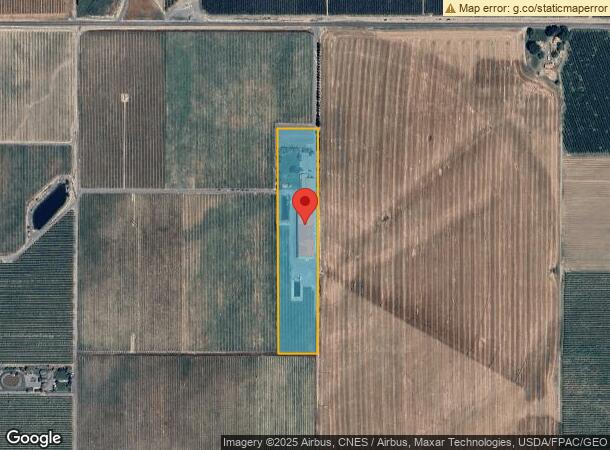
2020 Gilbert Rd, Zillah, WA 98953
NEARBY LISTINGS FOR SALE OR LEASE
Property Detail
2020 Gilbert Rd
201114-21003
SECTION 14 TOWNSHIP 11 RANGE 20 QUARTER NW BEG 889 FT N OF SE COR E1/2 NW1/4, TH S 89^42'48W 213 FT, TH N 0^19'48W 1215 FT, TH N 89^42'48E 220 FT, TH S 1215 FT TO POB, & EX N 30 FT CO RD R/W
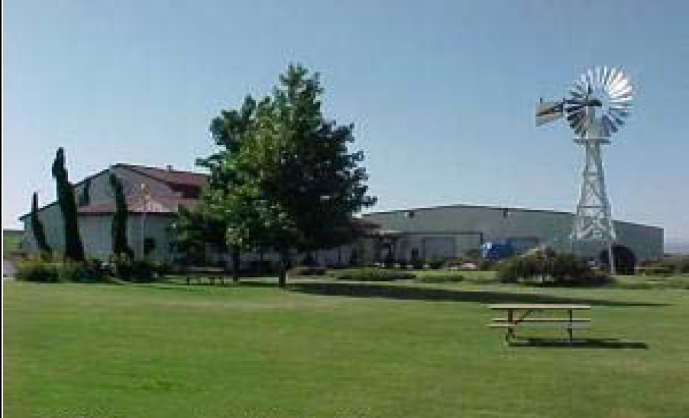
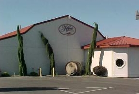
Restaurantbuilding
Yakima
X
Washington
53077C1460D
6.03 AC
2024
Outlying Yakima County
2023
Yakima
002202
Yakima, WA
27,400 SF
DEMOGRAPHICS near 2020 Gilbert Rd
1 Mile
3 Mile
5 Mile
2024 Total Population
153
3,960
9,141
2029 Population
152
3,875
8,991
Pop Growth 2024-2029
(0.65%)
(2.15%)
(1.64%)
Average Age
40
36
35
2024 Total Households
52
1,292
2,829
HH Growth 2024-2029
0.00%
(2.17%)
(1.77%)
Median Household Inc
$114,285
$68,840
$66,598
Avg Household Size
2.90
3.00
3.20
2024 Avg HH Vehicles
2.00
2.00
2.00
Median Home Value
$412,500
$318,810
$274,956
Median Year Built
1982
1975
1973
Nearby Places
- Restaurants
- Banks
- Shops
- Fitness
- Groceries
PUBLIC TRANSPORTATION
AIRPORT
Yakima Air Trml/McAllister Field
DRIVE
WALK
Distance
Yakima Air Trml/McAllister Field
34 min
19.5 mi
Freight Ports
Port of Tacoma
DRIVE
WALK
Distance
Port of Tacoma
210 min
173.6 mi
SALE & LEASE HISTORY
LISTING DATE
SALE/LEASE

Sep 23, 2016
For Sale
Nearby Properties
Address
Land Use
TOTAL SIZE
Lot Size
Zoning
Address
Land Use
TOTAL SIZE
Lot Size
Zoning
324,769 SF
93.16 AC
R1
Address
Land Use
TOTAL SIZE
Lot Size
Zoning
121,029 SF
8.42 AC
M1
Address
Land Use
TOTAL SIZE
Lot Size
Zoning
57,674 SF
31.43 AC
PC
Address
Land Use
TOTAL SIZE
Lot Size
Zoning
46,042 SF
5.97 AC
PC
Address
Land Use
TOTAL SIZE
Lot Size
Zoning
76,938 SF
6.86 AC
AG
Address
Land Use
TOTAL SIZE
Lot Size
Zoning
51,985 SF
1.61 AC
CT
Address
Land Use
TOTAL SIZE
Lot Size
Zoning
2,414 SF
195.87 AC
COM
Address
Land Use
TOTAL SIZE
Lot Size
Zoning
8,000 SF
2.71 AC
COM
Address
Land Use
TOTAL SIZE
Lot Size
Zoning
9,100 SF
0.84 AC
C1
Address
Land Use
TOTAL SIZE
Lot Size
Zoning
4,009 SF
2.23 AC
CT
Address
Land Use
TOTAL SIZE
Lot Size
Zoning
14,106 SF
5.16 AC
PC
Address
Land Use
TOTAL SIZE
Lot Size
Zoning
27,166 SF
3.39 AC
PD
Address
Land Use
TOTAL SIZE
Lot Size
Zoning
537.95 AC
AG
Address
Land Use
TOTAL SIZE
Lot Size
Zoning
38,488 SF
1.64 AC
PC
Address
Land Use
TOTAL SIZE
Lot Size
Zoning
5,239 SF
1.14 AC
CT
Address
Land Use
TOTAL SIZE
Lot Size
Zoning
12,079 SF
9.67 AC
AG
Address
Land Use
TOTAL SIZE
Lot Size
Zoning
22,592 SF
1.98 AC
COM
Address
Land Use
TOTAL SIZE
Lot Size
Zoning
15,615 SF
3.91 AC
C1
Address
Land Use
TOTAL SIZE
Lot Size
Zoning
8,640 SF
0.97 AC
COM
Address
Land Use
TOTAL SIZE
Lot Size
Zoning
20,800 SF
2.07 AC
C1
Address
Land Use
TOTAL SIZE
Lot Size
Zoning
5,823 SF
0.53 AC
CT
Address
Land Use
TOTAL SIZE
Lot Size
Zoning
12,828 SF
322.55 AC
RLDP
Address
Land Use
TOTAL SIZE
Lot Size
Zoning
14,080 SF
34.47 AC
AG
Address
Land Use
TOTAL SIZE
Lot Size
Zoning
59,669 SF
6.75 AC
AG
Address
Land Use
TOTAL SIZE
Lot Size
Zoning
5,880 SF
1.67 AC
COM
Address
Land Use
TOTAL SIZE
Lot Size
Zoning
19,140 SF
17.92 AC
PD
Address
Land Use
TOTAL SIZE
Lot Size
Zoning
12,829 SF
4.02 AC
AG
Address
Land Use
TOTAL SIZE
Lot Size
Zoning
1,496 SF
28.51 AC
R1
Address
Land Use
TOTAL SIZE
Lot Size
Zoning
43,680 SF
4.63 AC
M1
The World's #1 Commercial Real Estate Marketplace
Connect with us
© 2025 CoStar Group
The information above has been obtained from sources believed reliable. While we do not doubt its accuracy we have not verified it and make no guarantee, warranty or representation about it. It is your responsibility to independently confirm its accuracy and completeness. Any projections, opinions, assumptions, or estimates used are for example only and do not represent the current or future performance of the property. The value of this transaction to you depends on tax and other factors which should be evaluated by your tax, financial, and legal advisors. You and your advisors should conduct a careful, independent investigation of the property to determine to your satisfaction the suitability of the property for your needs.