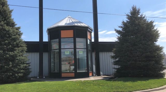
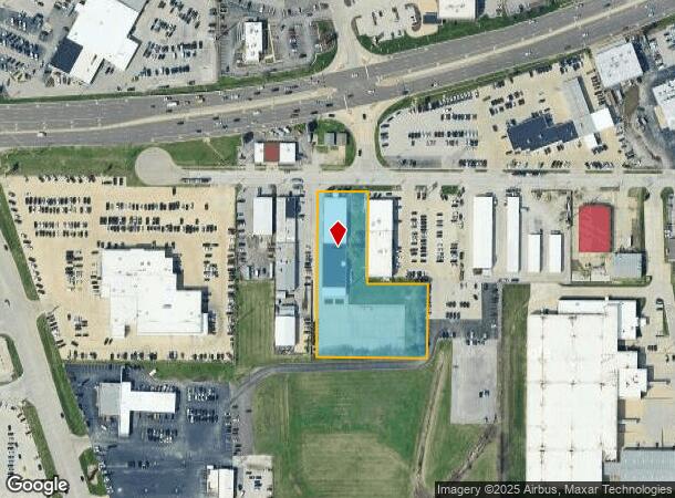
Property Record
2027 Ireland Grove Rd, Bloomington, IL 61704
NEARBY LISTINGS FOR SALE OR LEASE
Property Detail
2027 Ireland Grove Rd
21-15-226-033
Wilder Subdivision Which Is Part Of The
Commercialnec
PT NE BEG 1259.75W NE COR, E136, S276.83, E200, S200, W300, N476.83 TO POB
X
Mclean
17113C0504E
Illinois
2022
2.25 AC
2022
Bloomington/Normal
001108
Other Market Areas
30,240 SF
Bloomington, IL
DEMOGRAPHICS near 2027 Ireland Grove Rd
1 Mile
3 Mile
5 Mile
2024 Total Population
3,946
57,694
121,612
2029 Population
3,938
58,072
121,798
Pop Growth 2024-2029
(0.20%)
+ 0.66%
+ 0.15%
Average Age
42
39
37
2024 Total Households
2,109
26,046
49,676
HH Growth 2024-2029
(0.52%)
+ 0.66%
+ 0.17%
Median Household Inc
$59,482
$60,184
$66,831
Avg Household Size
1.80
2.10
2.20
2024 Avg HH Vehicles
1.00
2.00
2.00
Median Home Value
$144,444
$159,507
$179,977
Median Year Built
1973
1971
1979
Nearby Places
- Restaurants
- Banks
- Shops
- Fitness
- Groceries
PUBLIC TRANSPORTATION
COMMUTER RAIL
Bloomington-Normal (Lincoln Service - Amtrak, Lincoln Service Missouri River Runner - Amtrak, Texas Eagle - Amtrak)
DRIVE
WALK
Distance
Bloomington-Normal (Lincoln Service - Amtrak, Lincoln Service Missouri River Runner - Amtrak, Texas Eagle - Amtrak)
10 min
4.2 mi
AIRPORT
Central Il Regional/Bloomington-Normal
DRIVE
WALK
Distance
Central Il Regional/Bloomington-Normal
12 min
4.9 mi
Freight Ports
Port Milwaukee
DRIVE
WALK
Distance
Port Milwaukee
244 min
207.5 mi
SALE & LEASE HISTORY
LISTING DATE
SALE/LEASE

May 10, 2021
For Sale
Nearby Properties
Address
Land Use
TOTAL SIZE
Lot Size
Zoning
Address
Land Use
TOTAL SIZE
Lot Size
Zoning
131.22 AC
Address
Land Use
TOTAL SIZE
Lot Size
Zoning
1,867,780 SF
48.61 AC
Address
Land Use
TOTAL SIZE
Lot Size
Zoning
682,885 SF
44.48 AC
Address
Land Use
TOTAL SIZE
Lot Size
Zoning
562,852 SF
48.94 AC
Address
Land Use
TOTAL SIZE
Lot Size
Zoning
1,624,618 SF
54.32 AC
Address
Land Use
TOTAL SIZE
Lot Size
Zoning
454,529 SF
19.25 AC
Address
Land Use
TOTAL SIZE
Lot Size
Zoning
445,676 SF
20.86 AC
Address
Land Use
TOTAL SIZE
Lot Size
Zoning
333,419 SF
35.07 AC
Address
Land Use
TOTAL SIZE
Lot Size
Zoning
351,208 SF
15.91 AC
Address
Land Use
TOTAL SIZE
Lot Size
Zoning
733,822 SF
18.01 AC
Address
Land Use
TOTAL SIZE
Lot Size
Zoning
228,378 SF
7.99 AC
Address
Land Use
TOTAL SIZE
Lot Size
Zoning
275,860 SF
12.17 AC
Address
Land Use
TOTAL SIZE
Lot Size
Zoning
200,445 SF
8.33 AC
Address
Land Use
TOTAL SIZE
Lot Size
Zoning
362,086 SF
15.40 AC
Address
Land Use
TOTAL SIZE
Lot Size
Zoning
388,851 SF
4.40 AC
Address
Land Use
TOTAL SIZE
Lot Size
Zoning
276,695 SF
12.68 AC
Address
Land Use
TOTAL SIZE
Lot Size
Zoning
122,112 SF
7.16 AC
Address
Land Use
TOTAL SIZE
Lot Size
Zoning
295,802 SF
14.99 AC
Address
Land Use
TOTAL SIZE
Lot Size
Zoning
2,907 SF
96.29 AC
Address
Land Use
TOTAL SIZE
Lot Size
Zoning
223,726 SF
10.15 AC
Address
Land Use
TOTAL SIZE
Lot Size
Zoning
118,176 SF
2.30 AC
Address
Land Use
TOTAL SIZE
Lot Size
Zoning
97,514 SF
2.70 AC
Address
Land Use
TOTAL SIZE
Lot Size
Zoning
101,129 SF
1.49 AC
Address
Land Use
TOTAL SIZE
Lot Size
Zoning
98,540 SF
6.49 AC
Address
Land Use
TOTAL SIZE
Lot Size
Zoning
1,792 SF
31.52 AC
Address
Land Use
TOTAL SIZE
Lot Size
Zoning
51,422 SF
3.97 AC
Address
Land Use
TOTAL SIZE
Lot Size
Zoning
119,299 SF
8.91 AC
Address
Land Use
TOTAL SIZE
Lot Size
Zoning
150,550 SF
10.95 AC
Address
Land Use
TOTAL SIZE
Lot Size
Zoning
117,662 SF
5.07 AC
Address
Land Use
TOTAL SIZE
Lot Size
Zoning
77,653 SF
3.16 AC
The World's #1 Commercial Real Estate Marketplace
Connect with us
© 2025 CoStar Group
The information above has been obtained from sources believed reliable. While we do not doubt its accuracy we have not verified it and make no guarantee, warranty or representation about it. It is your responsibility to independently confirm its accuracy and completeness. Any projections, opinions, assumptions, or estimates used are for example only and do not represent the current or future performance of the property. The value of this transaction to you depends on tax and other factors which should be evaluated by your tax, financial, and legal advisors. You and your advisors should conduct a careful, independent investigation of the property to determine to your satisfaction the suitability of the property for your needs.