Property Record
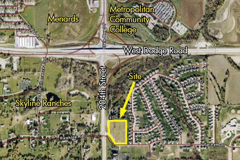
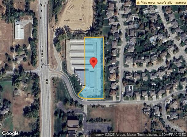
20302 Farnam St, Elkhorn, NE 68022
NEARBY LISTINGS FOR SALE OR LEASE
Property Detail
20302 Farnam St
Omaha-Council Bluffs, NE-IA
Elk Valley Business Park
1431-2522-10
ELK VALLEY BUSINESS PARK LOT 2 BLOCK 0 LOTS 1 & 2 4.76 AC
Publicstorage
Douglas
X
Nebraska
31055C0188J
2,1
2023
4.76 AC
2024
Suburban West Dodge
007523
Omaha/Council Bluffs
109,400 SF
DEMOGRAPHICS near 20302 Farnam St
1 Mile
3 Mile
5 Mile
2024 Total Population
5,365
48,297
125,229
2029 Population
5,435
49,243
127,034
Pop Growth 2024-2029
+ 1.30%
+ 1.96%
+ 1.44%
Average Age
37
38
38
2024 Total Households
1,650
17,317
44,739
HH Growth 2024-2029
+ 1.27%
+ 2.00%
+ 1.43%
Median Household Inc
$173,589
$132,314
$121,860
Avg Household Size
3.10
2.70
2.70
2024 Avg HH Vehicles
2.00
2.00
2.00
Median Home Value
$413,272
$378,713
$317,780
Median Year Built
2006
2006
2001
Nearby Places
- Restaurants
- Banks
- Shops
- Fitness
- Groceries
PUBLIC TRANSPORTATION
AIRPORT
Eppley Airfield
DRIVE
WALK
Distance
Eppley Airfield
37 min
20.0 mi
Freight Ports
Tulsa Port Of Catoosa
DRIVE
WALK
Distance
Tulsa Port Of Catoosa
484 min
434.4 mi
Nearby Properties
Address
Land Use
TOTAL SIZE
Lot Size
Zoning
Address
Land Use
TOTAL SIZE
Lot Size
Zoning
443,045 SF
22.82 AC
Address
Land Use
TOTAL SIZE
Lot Size
Zoning
486,568 SF
51.70 AC
ELKHORN
Address
Land Use
TOTAL SIZE
Lot Size
Zoning
382,741 SF
87.18 AC
GI
Address
Land Use
TOTAL SIZE
Lot Size
Zoning
449,891 SF
11.32 AC
Address
Land Use
TOTAL SIZE
Lot Size
Zoning
299,172 SF
13.80 AC
R7
Address
Land Use
TOTAL SIZE
Lot Size
Zoning
143,817 SF
16.67 AC
Address
Land Use
TOTAL SIZE
Lot Size
Zoning
143,817 SF
12.27 AC
Address
Land Use
TOTAL SIZE
Lot Size
Zoning
240,630 SF
5.38 AC
Address
Land Use
TOTAL SIZE
Lot Size
Zoning
241,312 SF
14.51 AC
Address
Land Use
TOTAL SIZE
Lot Size
Zoning
226,792 SF
8.97 AC
GO
Address
Land Use
TOTAL SIZE
Lot Size
Zoning
223,975 SF
11.91 AC
Address
Land Use
TOTAL SIZE
Lot Size
Zoning
87,510 SF
6.17 AC
Address
Land Use
TOTAL SIZE
Lot Size
Zoning
217,268 SF
8.23 AC
Address
Land Use
TOTAL SIZE
Lot Size
Zoning
316,737 SF
18.08 AC
Address
Land Use
TOTAL SIZE
Lot Size
Zoning
232,559 SF
13.53 AC
R6
Address
Land Use
TOTAL SIZE
Lot Size
Zoning
215,645 SF
5.19 AC
Address
Land Use
TOTAL SIZE
Lot Size
Zoning
233,520 SF
15.39 AC
Address
Land Use
TOTAL SIZE
Lot Size
Zoning
121,017 SF
13.23 AC
Address
Land Use
TOTAL SIZE
Lot Size
Zoning
222,090 SF
7.74 AC
R6
Address
Land Use
TOTAL SIZE
Lot Size
Zoning
137,800 SF
6.69 AC
Address
Land Use
TOTAL SIZE
Lot Size
Zoning
149,113 SF
7.64 AC
R6
Address
Land Use
TOTAL SIZE
Lot Size
Zoning
99,347 SF
4.50 AC
Address
Land Use
TOTAL SIZE
Lot Size
Zoning
107,052 SF
5.55 AC
Address
Land Use
TOTAL SIZE
Lot Size
Zoning
108,211 SF
6.53 AC
Address
Land Use
TOTAL SIZE
Lot Size
Zoning
149,976 SF
7.15 AC
Address
Land Use
TOTAL SIZE
Lot Size
Zoning
96,764 SF
5.48 AC
MU
Address
Land Use
TOTAL SIZE
Lot Size
Zoning
169,105 SF
14.11 AC
Address
Land Use
TOTAL SIZE
Lot Size
Zoning
63,614 SF
2.32 AC
Address
Land Use
TOTAL SIZE
Lot Size
Zoning
52,852 SF
2.83 AC
Address
Land Use
TOTAL SIZE
Lot Size
Zoning
182,501 SF
9.53 AC
The World's #1 Commercial Real Estate Marketplace
Connect with us
© 2025 CoStar Group
The information above has been obtained from sources believed reliable. While we do not doubt its accuracy we have not verified it and make no guarantee, warranty or representation about it. It is your responsibility to independently confirm its accuracy and completeness. Any projections, opinions, assumptions, or estimates used are for example only and do not represent the current or future performance of the property. The value of this transaction to you depends on tax and other factors which should be evaluated by your tax, financial, and legal advisors. You and your advisors should conduct a careful, independent investigation of the property to determine to your satisfaction the suitability of the property for your needs.