Property Record
2033 N Pinal Ave, Casa Grande, AZ 85122
NEARBY LISTINGS FOR SALE OR LEASE
Property Detail
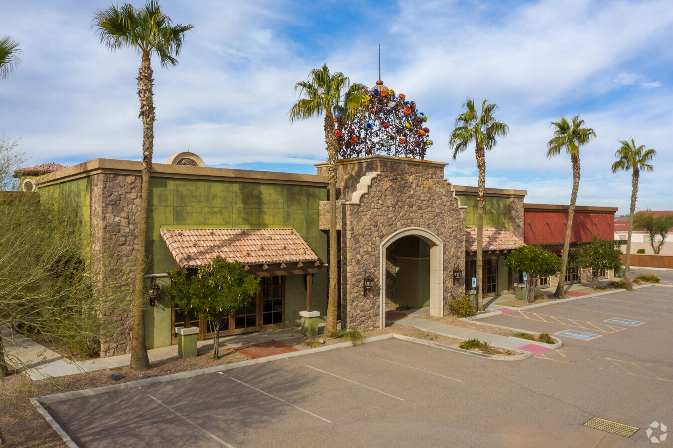
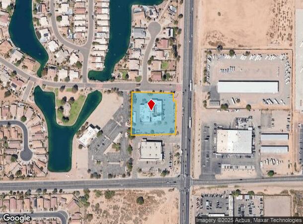
2033 N Pinal Ave
Phoenix-Mesa-Scottsdale, AZ
Casa Grande Lakes
504-51-162
CASA GRANDE LAKES PARCEL 4 LOT 1 SEC 7-6S-6E 80037 SQ FT 1.84 AC
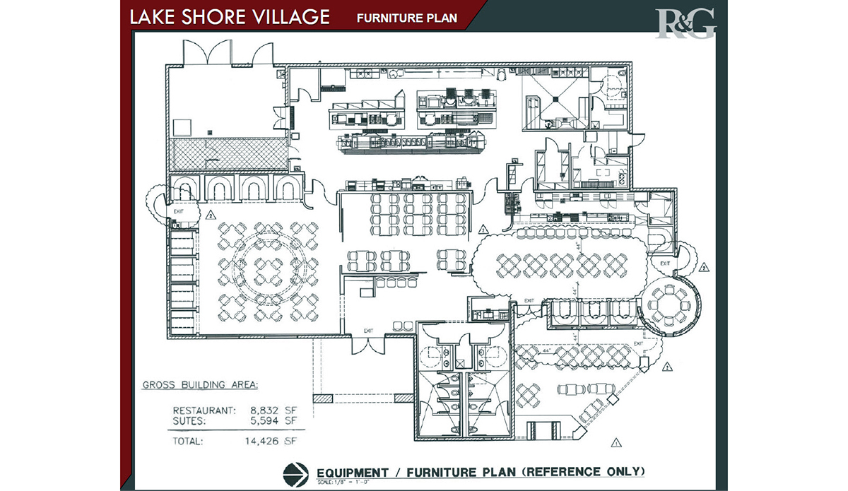
Restaurantbuilding
Pinal
X
Arizona
04021C1170E
1
2024
1.84 AC
2025
Outlying Pinal County
001307
Phoenix
13,146 SF
DEMOGRAPHICS near 2033 N Pinal Ave
1 Mile
3 Mile
5 Mile
2024 Total Population
7,714
51,802
63,910
2029 Population
9,737
65,733
80,990
Pop Growth 2024-2029
+ 26.23%
+ 26.89%
+ 26.73%
Average Age
42
39
40
2024 Total Households
2,997
18,314
22,948
HH Growth 2024-2029
+ 25.99%
+ 26.52%
+ 26.19%
Median Household Inc
$59,054
$62,562
$63,633
Avg Household Size
2.60
2.70
2.70
2024 Avg HH Vehicles
2.00
2.00
2.00
Median Home Value
$240,789
$237,990
$239,597
Median Year Built
2000
2000
2000
Nearby Places
- Restaurants
- Banks
- Shops
- Fitness
- Groceries
PUBLIC TRANSPORTATION
AIRPORT
Phoenix-Mesa Gateway
DRIVE
WALK
Distance
Phoenix-Mesa Gateway
57 min
39.1 mi
Freight Ports
Port of San Diego
DRIVE
WALK
Distance
Port of San Diego
378 min
351.1 mi
SALE & LEASE HISTORY
LISTING DATE
SALE/LEASE

Sep 07, 2018
For Sale
Oct 31, 2018
For Sale
Oct 25, 2018
For Lease
Oct 22, 2019
For Sale
May 24, 2021
For Sale
Mar 18, 2022
For Sale
Feb 13, 2017
For Sale
Nearby Properties
Address
Land Use
TOTAL SIZE
Lot Size
Zoning
Address
Land Use
TOTAL SIZE
Lot Size
Zoning
877,742 SF
125.20 AC
UNDESIGNAT
Address
Land Use
TOTAL SIZE
Lot Size
Zoning
525,773 SF
27.24 AC
UNDESIGNAT
Address
Land Use
TOTAL SIZE
Lot Size
Zoning
223,443 SF
176.81 AC
Address
Land Use
TOTAL SIZE
Lot Size
Zoning
289,599 SF
65.03 AC
Address
Land Use
TOTAL SIZE
Lot Size
Zoning
380,964 SF
36.62 AC
UNDESIGNAT
Address
Land Use
TOTAL SIZE
Lot Size
Zoning
286,759 SF
37.76 AC
UNDESIGNAT
Address
Land Use
TOTAL SIZE
Lot Size
Zoning
123,963 SF
15.43 AC
UNDESIGNAT
Address
Land Use
TOTAL SIZE
Lot Size
Zoning
196,294 SF
4.24 AC
Address
Land Use
TOTAL SIZE
Lot Size
Zoning
162,113 SF
20 AC
Address
Land Use
TOTAL SIZE
Lot Size
Zoning
172,746 SF
14.70 AC
UNDESIGNAT
Address
Land Use
TOTAL SIZE
Lot Size
Zoning
264,993 SF
26.48 AC
Address
Land Use
TOTAL SIZE
Lot Size
Zoning
55,295 SF
12.14 AC
Address
Land Use
TOTAL SIZE
Lot Size
Zoning
131,275 SF
8.85 AC
Address
Land Use
TOTAL SIZE
Lot Size
Zoning
107,832 SF
11.50 AC
Address
Land Use
TOTAL SIZE
Lot Size
Zoning
81,467 SF
11.96 AC
Address
Land Use
TOTAL SIZE
Lot Size
Zoning
121,969 SF
9.36 AC
Address
Land Use
TOTAL SIZE
Lot Size
Zoning
93,477 SF
4.22 AC
UNDESIGNAT
Address
Land Use
TOTAL SIZE
Lot Size
Zoning
111,066 SF
5.04 AC
UNDESIGNAT
Address
Land Use
TOTAL SIZE
Lot Size
Zoning
100,149 SF
10.59 AC
Address
Land Use
TOTAL SIZE
Lot Size
Zoning
137,735 SF
14.12 AC
Address
Land Use
TOTAL SIZE
Lot Size
Zoning
156,264 SF
10.70 AC
UNDESIGNAT
Address
Land Use
TOTAL SIZE
Lot Size
Zoning
395,597 SF
13.81 AC
Address
Land Use
TOTAL SIZE
Lot Size
Zoning
0.12 AC
Address
Land Use
TOTAL SIZE
Lot Size
Zoning
43,355 SF
5.91 AC
Address
Land Use
TOTAL SIZE
Lot Size
Zoning
320,334 SF
9.38 AC
Address
Land Use
TOTAL SIZE
Lot Size
Zoning
67,163 SF
24.27 AC
UNDESIGNAT
Address
Land Use
TOTAL SIZE
Lot Size
Zoning
32 AC
UNDESIGNAT
Address
Land Use
TOTAL SIZE
Lot Size
Zoning
840 SF
80 AC
Address
Land Use
TOTAL SIZE
Lot Size
Zoning
115,058 SF
13.41 AC
UNDESIGNAT
The World's #1 Commercial Real Estate Marketplace
Connect with us
© 2025 CoStar Group
The information above has been obtained from sources believed reliable. While we do not doubt its accuracy we have not verified it and make no guarantee, warranty or representation about it. It is your responsibility to independently confirm its accuracy and completeness. Any projections, opinions, assumptions, or estimates used are for example only and do not represent the current or future performance of the property. The value of this transaction to you depends on tax and other factors which should be evaluated by your tax, financial, and legal advisors. You and your advisors should conduct a careful, independent investigation of the property to determine to your satisfaction the suitability of the property for your needs.