Property Record
2037 Old Candler Rd, Gainesville, GA 30507
NEARBY LISTINGS FOR SALE OR LEASE
Property Detail
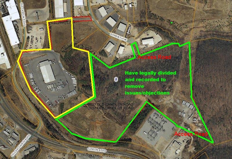
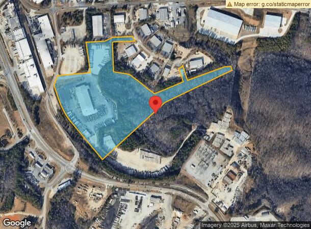
2037 Old Candler Rd
Gainesville, GA
Plat Prepared Doug Allen 03 Su
15-00032-00-083
1305 OLD CANDLER ROAD S W
Officebuilding
Hall
X
Georgia
13139C0189G
0
2024
27.43 AC
2024
Gainesville/Hall County
001204
Atlanta
67,938 SF
DEMOGRAPHICS near 2037 Old Candler Rd
1 Mile
3 Mile
5 Mile
2024 Total Population
894
29,616
83,016
2029 Population
975
32,666
91,790
Pop Growth 2024-2029
+ 9.06%
+ 10.30%
+ 10.57%
Average Age
34
32
36
2024 Total Households
187
8,445
27,605
HH Growth 2024-2029
+ 8.56%
+ 10.27%
+ 10.55%
Median Household Inc
$58,999
$45,804
$55,426
Avg Household Size
3.40
3.20
2.90
2024 Avg HH Vehicles
2.00
2.00
2.00
Median Home Value
$202,128
$169,009
$233,880
Median Year Built
1994
1986
1992
Nearby Places
- Restaurants
- Banks
- Shops
- Fitness
- Groceries
PUBLIC TRANSPORTATION
COMMUTER RAIL
Gainesville Amtrak Station (Crescent - Amtrak)
DRIVE
WALK
Distance
Gainesville Amtrak Station (Crescent - Amtrak)
6 min
2.6 mi
Freight Ports
Georgia Ports - Savannah
DRIVE
WALK
Distance
Georgia Ports - Savannah
319 min
251.9 mi
Nearby Properties
Address
Land Use
TOTAL SIZE
Lot Size
Zoning
Address
Land Use
TOTAL SIZE
Lot Size
Zoning
564,132 SF
48.45 AC
EX
Address
Land Use
TOTAL SIZE
Lot Size
Zoning
578,645 SF
110.18 AC
PUD
Address
Land Use
TOTAL SIZE
Lot Size
Zoning
39,637 SF
31.55 AC
R-II
Address
Land Use
TOTAL SIZE
Lot Size
Zoning
27,221 SF
2.23 AC
G-B
Address
Land Use
TOTAL SIZE
Lot Size
Zoning
334,800 SF
56.96 AC
PUD
Address
Land Use
TOTAL SIZE
Lot Size
Zoning
2,160 SF
5.60 AC
PUD
Address
Land Use
TOTAL SIZE
Lot Size
Zoning
760,440 SF
53.33 AC
L-I
Address
Land Use
TOTAL SIZE
Lot Size
Zoning
3,284 SF
28.53 AC
PUD
Address
Land Use
TOTAL SIZE
Lot Size
Zoning
277,684 SF
23.06 AC
L-I
Address
Land Use
TOTAL SIZE
Lot Size
Zoning
77,333 SF
11.74 AC
G-B
Address
Land Use
TOTAL SIZE
Lot Size
Zoning
54,751 SF
33.38 AC
EX
Address
Land Use
TOTAL SIZE
Lot Size
Zoning
346,875 SF
82.09 AC
H-I
Address
Land Use
TOTAL SIZE
Lot Size
Zoning
100,864 SF
4.10 AC
PUD
Address
Land Use
TOTAL SIZE
Lot Size
Zoning
469,180 SF
25.56 AC
L-I
Address
Land Use
TOTAL SIZE
Lot Size
Zoning
44,388 SF
1.66 AC
O-I
Address
Land Use
TOTAL SIZE
Lot Size
Zoning
6,852 SF
3.15 AC
PUD
Address
Land Use
TOTAL SIZE
Lot Size
Zoning
258,372 SF
24.38 AC
L-I
Address
Land Use
TOTAL SIZE
Lot Size
Zoning
46,795 SF
17.38 AC
PUD
Address
Land Use
TOTAL SIZE
Lot Size
Zoning
102,317 SF
6.90 AC
PUD
Address
Land Use
TOTAL SIZE
Lot Size
Zoning
258,800 SF
52.20 AC
H-I
Address
Land Use
TOTAL SIZE
Lot Size
Zoning
88,042 SF
280.24 AC
PID
Address
Land Use
TOTAL SIZE
Lot Size
Zoning
308,672 SF
41.22 AC
L-I
Address
Land Use
TOTAL SIZE
Lot Size
Zoning
4,370 SF
262.63 AC
H-I
Address
Land Use
TOTAL SIZE
Lot Size
Zoning
1,441 SF
10.46 AC
R-II
Address
Land Use
TOTAL SIZE
Lot Size
Zoning
140,805 SF
3.74 AC
G-B
Address
Land Use
TOTAL SIZE
Lot Size
Zoning
91,728 SF
15 AC
L-I
Address
Land Use
TOTAL SIZE
Lot Size
Zoning
3,696 SF
11.89 AC
R-I
Address
Land Use
TOTAL SIZE
Lot Size
Zoning
67,383 SF
1.68 AC
C-B
Address
Land Use
TOTAL SIZE
Lot Size
Zoning
69,888 SF
5.37 AC
O-I
Address
Land Use
TOTAL SIZE
Lot Size
Zoning
60,062 SF
0.51 AC
C-B
The World's #1 Commercial Real Estate Marketplace
Connect with us
© 2025 CoStar Group
The information above has been obtained from sources believed reliable. While we do not doubt its accuracy we have not verified it and make no guarantee, warranty or representation about it. It is your responsibility to independently confirm its accuracy and completeness. Any projections, opinions, assumptions, or estimates used are for example only and do not represent the current or future performance of the property. The value of this transaction to you depends on tax and other factors which should be evaluated by your tax, financial, and legal advisors. You and your advisors should conduct a careful, independent investigation of the property to determine to your satisfaction the suitability of the property for your needs.