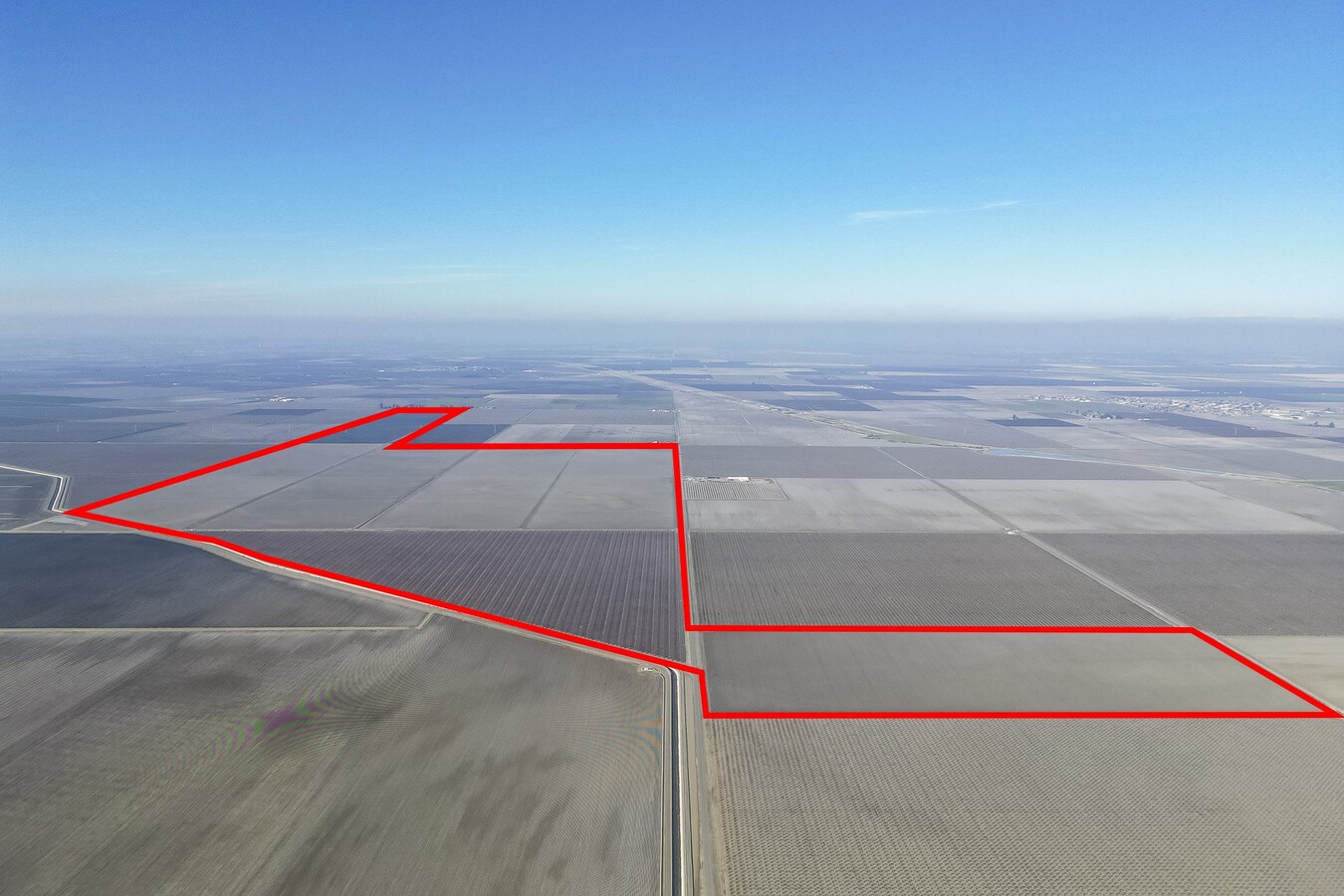
Property Record
20375 W Manning Ave, San Joaquin, CA 93660
NEARBY LISTINGS FOR SALE OR LEASE
Property Detail
20375 W Manning Ave
Fresno, CA
SUR RTS 159.92 AC 4 LOTS TRANQUILLITY COL #9
030-111-73
Fresno
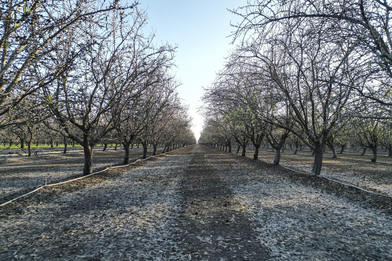
Orchard
California
X
5,12
06019C2550H
58.88 AC
2023
W Outlying Fresno County
2023
Fresno
DEMOGRAPHICS near 20375 W Manning Ave
1 Mile
3 Mile
5 Mile
2024 Total Population
15
3,137
3,382
2029 Population
15
3,021
3,256
Pop Growth 2024-2029
0.00%
(3.70%)
(3.73%)
Average Age
33
32
32
2024 Total Households
4
765
826
HH Growth 2024-2029
0.00%
(3.92%)
(4.00%)
Median Household Inc
$87,500
$41,111
$45,167
Avg Household Size
3.00
4.00
4.00
2024 Avg HH Vehicles
3.00
2.00
2.00
Median Home Value
$750,000
$239,285
$245,275
Median Year Built
1959
1985
1985
Nearby Places
- Restaurants
- Banks
- Shops
- Fitness
- Groceries
PUBLIC TRANSPORTATION
AIRPORT
Fresno Yosemite International
DRIVE
WALK
Distance
Fresno Yosemite International
51 min
34.9 mi
Freight Ports
Port of Stockton
DRIVE
WALK
Distance
Port of Stockton
161 min
133.1 mi
SALE & LEASE HISTORY
LISTING DATE
SALE/LEASE

Feb 01, 2023
For Sale
Apr 03, 2024
For Sale
Nearby Properties
Address
Land Use
TOTAL SIZE
Lot Size
Zoning
Address
Land Use
TOTAL SIZE
Lot Size
Zoning
8,430 SF
6.32 AC
ML
Address
Land Use
TOTAL SIZE
Lot Size
Zoning
54,588 SF
7.03 AC
RM
Address
Land Use
TOTAL SIZE
Lot Size
Zoning
1,408 SF
57.56 AC
AE20
Address
Land Use
TOTAL SIZE
Lot Size
Zoning
636.48 AC
AE20
Address
Land Use
TOTAL SIZE
Lot Size
Zoning
1,378 SF
323.42 AC
AE20
Address
Land Use
TOTAL SIZE
Lot Size
Zoning
16,239 SF
3.21 AC
CG
Address
Land Use
TOTAL SIZE
Lot Size
Zoning
1,498 SF
276.30 AC
AE20
Address
Land Use
TOTAL SIZE
Lot Size
Zoning
99,375 SF
10.35 AC
M1
Address
Land Use
TOTAL SIZE
Lot Size
Zoning
102,564 SF
13.09 AC
RM
Address
Land Use
TOTAL SIZE
Lot Size
Zoning
67,400 SF
3.66 AC
M1
Address
Land Use
TOTAL SIZE
Lot Size
Zoning
200 AC
AE20
Address
Land Use
TOTAL SIZE
Lot Size
Zoning
1,488 SF
163.14 AC
AE20
Address
Land Use
TOTAL SIZE
Lot Size
Zoning
38,054 SF
3.19 AC
HC
Address
Land Use
TOTAL SIZE
Lot Size
Zoning
8,320 SF
0.94 AC
HC
Address
Land Use
TOTAL SIZE
Lot Size
Zoning
79.38 AC
AE20
Address
Land Use
TOTAL SIZE
Lot Size
Zoning
28,900 SF
12.95 AC
M1
Address
Land Use
TOTAL SIZE
Lot Size
Zoning
3,837 SF
19.44 AC
AE20
Address
Land Use
TOTAL SIZE
Lot Size
Zoning
35,612 SF
3.15 AC
HC
Address
Land Use
TOTAL SIZE
Lot Size
Zoning
4,874 SF
52 AC
AE20
Address
Land Use
TOTAL SIZE
Lot Size
Zoning
27,635 SF
1.23 AC
M1
Address
Land Use
TOTAL SIZE
Lot Size
Zoning
16,192 SF
3.08 AC
M1
Address
Land Use
TOTAL SIZE
Lot Size
Zoning
39.44 AC
AE20
Address
Land Use
TOTAL SIZE
Lot Size
Zoning
775 SF
76.66 AC
AE20
Address
Land Use
TOTAL SIZE
Lot Size
Zoning
1,917 SF
10.38 AC
AE20
Address
Land Use
TOTAL SIZE
Lot Size
Zoning
1,575 SF
75.19 AC
AE20
Address
Land Use
TOTAL SIZE
Lot Size
Zoning
27,960 SF
2.99 AC
ML
Address
Land Use
TOTAL SIZE
Lot Size
Zoning
24,800 SF
2.31 AC
AE20
Address
Land Use
TOTAL SIZE
Lot Size
Zoning
35.39 AC
AE20
Address
Land Use
TOTAL SIZE
Lot Size
Zoning
1,000 SF
241.02 AC
AE20
Address
Land Use
TOTAL SIZE
Lot Size
Zoning
14,767 SF
1.83 AC
HC
The World's #1 Commercial Real Estate Marketplace
Connect with us
© 2025 CoStar Group
The information above has been obtained from sources believed reliable. While we do not doubt its accuracy we have not verified it and make no guarantee, warranty or representation about it. It is your responsibility to independently confirm its accuracy and completeness. Any projections, opinions, assumptions, or estimates used are for example only and do not represent the current or future performance of the property. The value of this transaction to you depends on tax and other factors which should be evaluated by your tax, financial, and legal advisors. You and your advisors should conduct a careful, independent investigation of the property to determine to your satisfaction the suitability of the property for your needs.