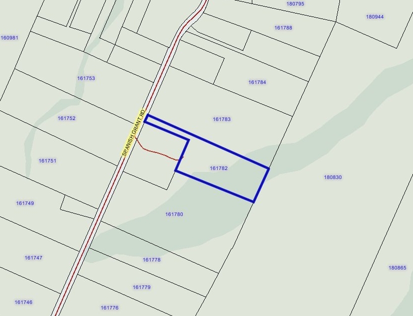
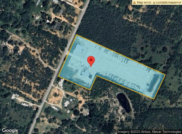
Property Record
20474 Spanish Grant Rd, San Antonio, TX 78264
NEARBY LISTINGS FOR SALE OR LEASE
Property Detail
20474 Spanish Grant Rd
San Antonio-New Braunfels, TX
Griffith Sub
04011-500-0381
CB 4011E LOT TR-38 REFER TO: 80700-001-0030 CB 4011M BLK 1 LOT 2 GRIFFITH SUBD SEE NOTES FOR REFER TO 2012-MERGED PER CR 26529
Autorepair
Bexar
A
Texas
48493C0250C
381
2023
10 AC
2023
South
152201
San Antonio
8,296 SF
DEMOGRAPHICS near 20474 Spanish Grant Rd
1 Mile
3 Mile
5 Mile
2024 Total Population
683
8,322
21,658
2029 Population
748
8,994
23,205
Pop Growth 2024-2029
+ 9.52%
+ 8.07%
+ 7.14%
Average Age
35
36
36
2024 Total Households
201
2,514
6,568
HH Growth 2024-2029
+ 9.45%
+ 8.11%
+ 7.25%
Median Household Inc
$29,374
$34,155
$43,646
Avg Household Size
3.20
3.10
3.20
2024 Avg HH Vehicles
2.00
2.00
2.00
Median Home Value
$141,011
$147,654
$142,776
Median Year Built
1999
1997
1995
Nearby Places
- Restaurants
- Banks
- Shops
- Fitness
- Groceries
PUBLIC TRANSPORTATION
AIRPORT
San Antonio International
DRIVE
WALK
Distance
San Antonio International
33 min
27.5 mi
Freight Ports
Port of Corpus Christi
DRIVE
WALK
Distance
Port of Corpus Christi
134 min
129.7 mi
Nearby Properties
Address
Land Use
TOTAL SIZE
Lot Size
Zoning
Address
Land Use
TOTAL SIZE
Lot Size
Zoning
211,505 SF
21.04 AC
Address
Land Use
TOTAL SIZE
Lot Size
Zoning
57,863 SF
36.23 AC
Address
Land Use
TOTAL SIZE
Lot Size
Zoning
5,753,521 SF
709.61 AC
Address
Land Use
TOTAL SIZE
Lot Size
Zoning
80,652 SF
18.26 AC
Address
Land Use
TOTAL SIZE
Lot Size
Zoning
300.90 AC
Address
Land Use
TOTAL SIZE
Lot Size
Zoning
Address
Land Use
TOTAL SIZE
Lot Size
Zoning
47,314 SF
4.53 AC
Address
Land Use
TOTAL SIZE
Lot Size
Zoning
1,124 SF
414.76 AC
Address
Land Use
TOTAL SIZE
Lot Size
Zoning
10,440 SF
13.90 AC
Address
Land Use
TOTAL SIZE
Lot Size
Zoning
1,056 SF
304.42 AC
Address
Land Use
TOTAL SIZE
Lot Size
Zoning
43.73 AC
Address
Land Use
TOTAL SIZE
Lot Size
Zoning
500.22 AC
Address
Land Use
TOTAL SIZE
Lot Size
Zoning
203.51 AC
Address
Land Use
TOTAL SIZE
Lot Size
Zoning
363.64 AC
Address
Land Use
TOTAL SIZE
Lot Size
Zoning
198.25 AC
Address
Land Use
TOTAL SIZE
Lot Size
Zoning
221.72 AC
Address
Land Use
TOTAL SIZE
Lot Size
Zoning
271.41 AC
Address
Land Use
TOTAL SIZE
Lot Size
Zoning
136.35 AC
Address
Land Use
TOTAL SIZE
Lot Size
Zoning
181.82 AC
Address
Land Use
TOTAL SIZE
Lot Size
Zoning
146.83 AC
Address
Land Use
TOTAL SIZE
Lot Size
Zoning
21,562 SF
6.88 AC
Address
Land Use
TOTAL SIZE
Lot Size
Zoning
420 SF
150 AC
Address
Land Use
TOTAL SIZE
Lot Size
Zoning
99.64 AC
Address
Land Use
TOTAL SIZE
Lot Size
Zoning
99.64 AC
Address
Land Use
TOTAL SIZE
Lot Size
Zoning
29,400 SF
1.38 AC
Address
Land Use
TOTAL SIZE
Lot Size
Zoning
179.87 AC
Address
Land Use
TOTAL SIZE
Lot Size
Zoning
3,183 SF
2.23 AC
Address
Land Use
TOTAL SIZE
Lot Size
Zoning
25,872 SF
9.11 AC
Address
Land Use
TOTAL SIZE
Lot Size
Zoning
224.15 AC
Address
Land Use
TOTAL SIZE
Lot Size
Zoning
784 SF
20.19 AC
The World's #1 Commercial Real Estate Marketplace
Connect with us
© 2025 CoStar Group
The information above has been obtained from sources believed reliable. While we do not doubt its accuracy we have not verified it and make no guarantee, warranty or representation about it. It is your responsibility to independently confirm its accuracy and completeness. Any projections, opinions, assumptions, or estimates used are for example only and do not represent the current or future performance of the property. The value of this transaction to you depends on tax and other factors which should be evaluated by your tax, financial, and legal advisors. You and your advisors should conduct a careful, independent investigation of the property to determine to your satisfaction the suitability of the property for your needs.