Property Record
205 Sandra Ave, Mendota, IL 61342
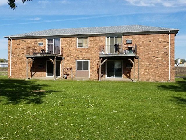
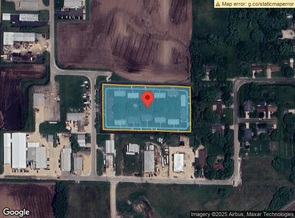
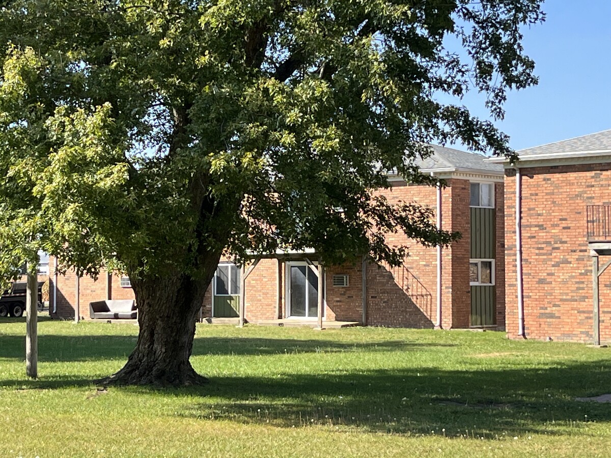
This Property Is For Sale
NEARBY LISTINGS FOR SALE OR LEASE
-
-
View all Mendota listings for sale on LoopNet.com
Property Detail
205 Sandra Ave
Ottawa-Peru, IL
Wentworth Commons Apartment Sub
01-32-421015
WENTWORTH COMMONS APTS, LTS 1 THRU 14 SEC 32-36-1
Commercialnec
La Salle
X
Illinois
17099C0167G
1-14
2023
3.32 AC
2023
La Salle County
961900
Chicago
3,432 SF
DEMOGRAPHICS near 205 Sandra Ave
1 Mile
3 Mile
5 Mile
2024 Total Population
3,917
7,713
8,046
2029 Population
3,840
7,578
7,894
Pop Growth 2024-2029
(1.97%)
(1.75%)
(1.89%)
Average Age
41
41
41
2024 Total Households
1,595
3,060
3,198
HH Growth 2024-2029
(2.07%)
(1.86%)
(2.00%)
Median Household Inc
$65,117
$69,021
$70,006
Avg Household Size
2.40
2.40
2.40
2024 Avg HH Vehicles
2.00
2.00
2.00
Median Home Value
$141,176
$135,662
$137,612
Median Year Built
1959
1959
1959
Nearby Places
- Restaurants
- Banks
- Shops
- Fitness
- Groceries
PUBLIC TRANSPORTATION
COMMUTER RAIL
Mendota Amtrak Station (Carl Sandburg - Amtrak, Illinois Zephyr - Amtrak, Southwest Chief - Amtrak)
DRIVE
WALK
Distance
Mendota Amtrak Station (Carl Sandburg - Amtrak, Illinois Zephyr - Amtrak, Southwest Chief - Amtrak)
4 min
1.5 mi
Freight Ports
Port Milwaukee
DRIVE
WALK
Distance
Port Milwaukee
169 min
146.0 mi
Nearby Properties
Address
Land Use
TOTAL SIZE
Lot Size
Zoning
Address
Land Use
TOTAL SIZE
Lot Size
Zoning
37.10 AC
Address
Land Use
TOTAL SIZE
Lot Size
Zoning
245,030 SF
14.36 AC
Address
Land Use
TOTAL SIZE
Lot Size
Zoning
202,418 SF
15.50 AC
Address
Land Use
TOTAL SIZE
Lot Size
Zoning
27,741 SF
5.98 AC
Address
Land Use
TOTAL SIZE
Lot Size
Zoning
149,296 SF
19.53 AC
Address
Land Use
TOTAL SIZE
Lot Size
Zoning
9,000 SF
12.82 AC
Address
Land Use
TOTAL SIZE
Lot Size
Zoning
90,000 SF
19.30 AC
Address
Land Use
TOTAL SIZE
Lot Size
Zoning
4,200 SF
0.84 AC
Address
Land Use
TOTAL SIZE
Lot Size
Zoning
92,574 SF
14.32 AC
Address
Land Use
TOTAL SIZE
Lot Size
Zoning
60,473 SF
16.58 AC
Address
Land Use
TOTAL SIZE
Lot Size
Zoning
50,650 SF
8.44 AC
Address
Land Use
TOTAL SIZE
Lot Size
Zoning
25,637 SF
9.09 AC
Address
Land Use
TOTAL SIZE
Lot Size
Zoning
36,500 SF
15.03 AC
Address
Land Use
TOTAL SIZE
Lot Size
Zoning
11,628 SF
0.32 AC
Address
Land Use
TOTAL SIZE
Lot Size
Zoning
24,894 SF
8.34 AC
Address
Land Use
TOTAL SIZE
Lot Size
Zoning
13,575 SF
1.68 AC
Address
Land Use
TOTAL SIZE
Lot Size
Zoning
12,784 SF
2.36 AC
Address
Land Use
TOTAL SIZE
Lot Size
Zoning
41,613 SF
207.86 AC
Address
Land Use
TOTAL SIZE
Lot Size
Zoning
29,400 SF
1.71 AC
Address
Land Use
TOTAL SIZE
Lot Size
Zoning
4,200 SF
1.26 AC
Address
Land Use
TOTAL SIZE
Lot Size
Zoning
5,506 SF
0.85 AC
Address
Land Use
TOTAL SIZE
Lot Size
Zoning
55,319 SF
1.87 AC
Address
Land Use
TOTAL SIZE
Lot Size
Zoning
15,750 SF
4.08 AC
Address
Land Use
TOTAL SIZE
Lot Size
Zoning
10,640 SF
1.37 AC
Address
Land Use
TOTAL SIZE
Lot Size
Zoning
4,995 SF
0.87 AC
Address
Land Use
TOTAL SIZE
Lot Size
Zoning
8,000 SF
0.98 AC
Address
Land Use
TOTAL SIZE
Lot Size
Zoning
75,951 SF
3.50 AC
Address
Land Use
TOTAL SIZE
Lot Size
Zoning
3,565 SF
0.85 AC
Address
Land Use
TOTAL SIZE
Lot Size
Zoning
11,200 SF
1 AC
The World's #1 Commercial Real Estate Marketplace
Connect with us
© 2025 CoStar Group
The information above has been obtained from sources believed reliable. While we do not doubt its accuracy we have not verified it and make no guarantee, warranty or representation about it. It is your responsibility to independently confirm its accuracy and completeness. Any projections, opinions, assumptions, or estimates used are for example only and do not represent the current or future performance of the property. The value of this transaction to you depends on tax and other factors which should be evaluated by your tax, financial, and legal advisors. You and your advisors should conduct a careful, independent investigation of the property to determine to your satisfaction the suitability of the property for your needs.