Property Record
205 Copper Top Ln Ne, Cleveland, TN 37312
NEARBY LISTINGS FOR SALE OR LEASE
Property Detail
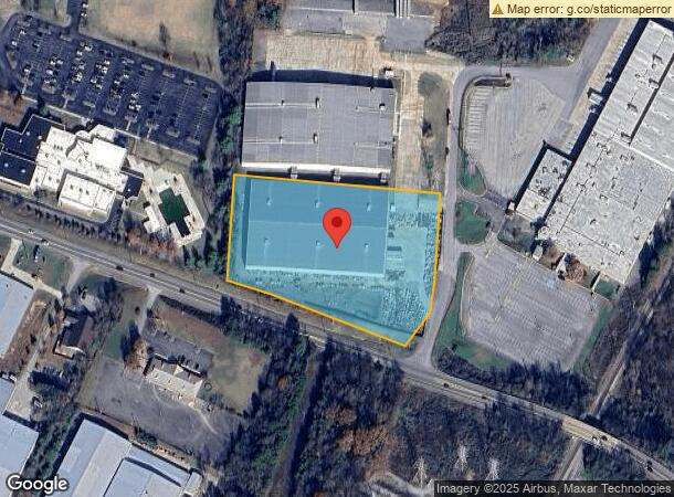
205 Copper Top Ln Ne
042-005.10
Raymond D Beavers
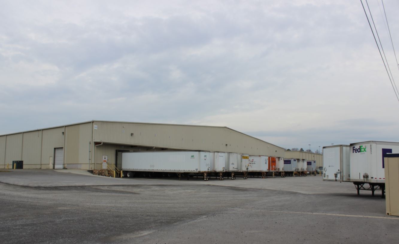
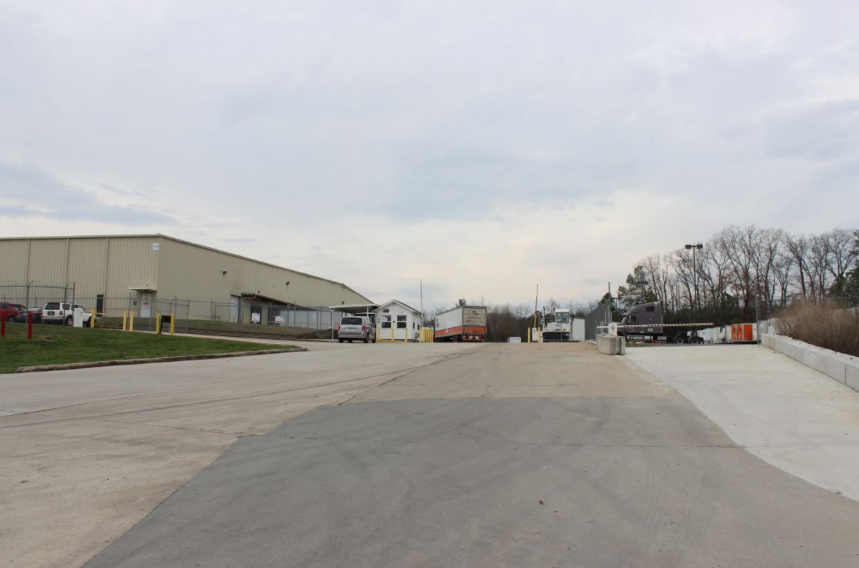
Industrialgeneral
TRI STATE WAREHOUSE
X
Bradley
47011C0137E
Tennessee
2024
5.10 AC
2024
Tennessee East Area
011201
Other Market Areas
100,000 SF
Cleveland, TN
DEMOGRAPHICS near 205 Copper Top Ln Ne
1 Mile
3 Mile
5 Mile
2024 Total Population
3,584
28,907
70,053
2029 Population
3,778
30,561
73,925
Pop Growth 2024-2029
+ 5.41%
+ 5.72%
+ 5.53%
Average Age
40
40
40
2024 Total Households
1,410
11,421
27,274
HH Growth 2024-2029
+ 5.46%
+ 5.87%
+ 5.71%
Median Household Inc
$57,638
$56,313
$54,745
Avg Household Size
2.50
2.50
2.50
2024 Avg HH Vehicles
2.00
2.00
2.00
Median Home Value
$195,057
$215,907
$217,763
Median Year Built
1993
1989
1985
Nearby Places
- Restaurants
- Banks
- Shops
- Fitness
- Groceries
PUBLIC TRANSPORTATION
AIRPORT
Lovell Field
DRIVE
WALK
Distance
Lovell Field
41 min
29.3 mi
Freight Ports
Georgia Ports - Savannah
DRIVE
WALK
Distance
Georgia Ports - Savannah
426 min
369.8 mi
SALE & LEASE HISTORY
LISTING DATE
SALE/LEASE

Jun 08, 2017
For Sale
Nearby Properties
Address
Land Use
TOTAL SIZE
Lot Size
Zoning
Address
Land Use
TOTAL SIZE
Lot Size
Zoning
400,000 SF
123.44 AC
IH
Address
Land Use
TOTAL SIZE
Lot Size
Zoning
267,460 SF
8.30 AC
IL
Address
Land Use
TOTAL SIZE
Lot Size
Zoning
400,562 SF
15.26 AC
PI
Address
Land Use
TOTAL SIZE
Lot Size
Zoning
8,680 SF
355.73 AC
IL
Address
Land Use
TOTAL SIZE
Lot Size
Zoning
118,230 SF
37 AC
FAR
Address
Land Use
TOTAL SIZE
Lot Size
Zoning
68,425 SF
76.31 AC
MU
Address
Land Use
TOTAL SIZE
Lot Size
Zoning
68,785 SF
8.70 AC
R1
Address
Land Use
TOTAL SIZE
Lot Size
Zoning
356,920 SF
26.42 AC
IL
Address
Land Use
TOTAL SIZE
Lot Size
Zoning
93,264 SF
17.60 AC
CH
Address
Land Use
TOTAL SIZE
Lot Size
Zoning
74,392 SF
17.39 AC
MU
Address
Land Use
TOTAL SIZE
Lot Size
Zoning
620,857 SF
34.28 AC
IH
Address
Land Use
TOTAL SIZE
Lot Size
Zoning
170,518 SF
4.96 AC
CH
Address
Land Use
TOTAL SIZE
Lot Size
Zoning
65,382 SF
63.70 AC
FAR
Address
Land Use
TOTAL SIZE
Lot Size
Zoning
423,535 SF
56.59 AC
IH
Address
Land Use
TOTAL SIZE
Lot Size
Zoning
530,452 SF
30 AC
IL
Address
Land Use
TOTAL SIZE
Lot Size
Zoning
66,331 SF
10.87 AC
IL
Address
Land Use
TOTAL SIZE
Lot Size
Zoning
782,652 SF
43.40 AC
C-1
Address
Land Use
TOTAL SIZE
Lot Size
Zoning
203,778 SF
13.46 AC
R3
Address
Land Use
TOTAL SIZE
Lot Size
Zoning
416,503 SF
61.92 AC
CH
Address
Land Use
TOTAL SIZE
Lot Size
Zoning
96,527 SF
5.15 AC
CH
Address
Land Use
TOTAL SIZE
Lot Size
Zoning
203,751 SF
19.34 AC
CH
Address
Land Use
TOTAL SIZE
Lot Size
Zoning
28,351 SF
0.50 AC
I1
Address
Land Use
TOTAL SIZE
Lot Size
Zoning
56,725 SF
13.06 AC
R1
Address
Land Use
TOTAL SIZE
Lot Size
Zoning
265,226 SF
25.90 AC
CH
Address
Land Use
TOTAL SIZE
Lot Size
Zoning
86,435 SF
7.68 AC
CH
Address
Land Use
TOTAL SIZE
Lot Size
Zoning
37,430 SF
5.75 AC
CH
Address
Land Use
TOTAL SIZE
Lot Size
Zoning
15,044 SF
93.90 AC
IH
Address
Land Use
TOTAL SIZE
Lot Size
Zoning
44.30 AC
IH
Address
Land Use
TOTAL SIZE
Lot Size
Zoning
82,190 SF
6.53 AC
PI
Address
Land Use
TOTAL SIZE
Lot Size
Zoning
122,596 SF
5.98 AC
PUD
The World's #1 Commercial Real Estate Marketplace
Connect with us
© 2025 CoStar Group
The information above has been obtained from sources believed reliable. While we do not doubt its accuracy we have not verified it and make no guarantee, warranty or representation about it. It is your responsibility to independently confirm its accuracy and completeness. Any projections, opinions, assumptions, or estimates used are for example only and do not represent the current or future performance of the property. The value of this transaction to you depends on tax and other factors which should be evaluated by your tax, financial, and legal advisors. You and your advisors should conduct a careful, independent investigation of the property to determine to your satisfaction the suitability of the property for your needs.