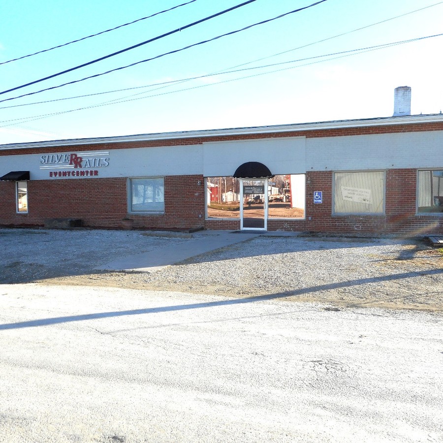
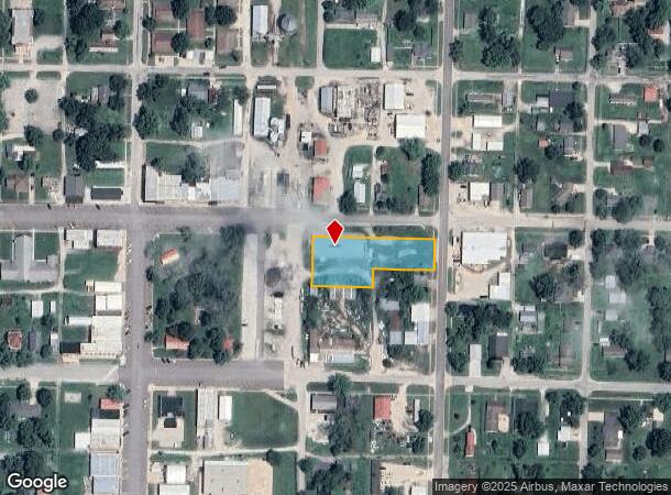
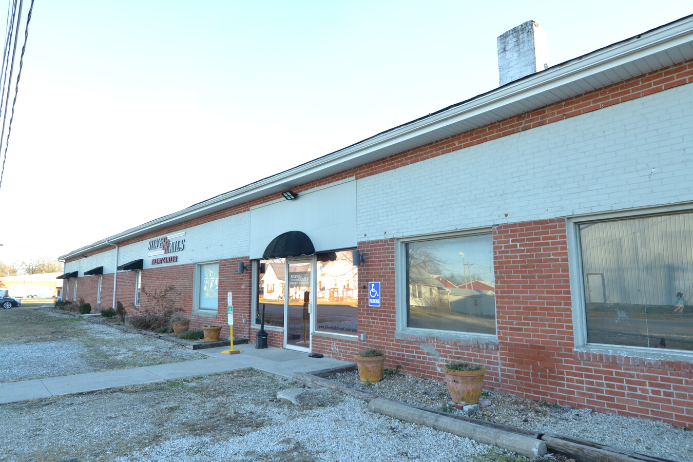
Property Record
206 E Moore St, La Plata, MO 63549
NEARBY LISTINGS FOR SALE OR LEASE
-
-
View all La Plata listings for sale on LoopNet.com
Property Detail
206 E Moore St
060402-0308-02033-000100
Williamsons 1St Add
Recreationalentertainmentgeneral
THE N 68' OF LOTS 1, 2, 3, 4; ALL OF LOTS 5,6,7 AND EX 75' M/L OF VAC ALLEY
X
Macon
29121C0090C
Missouri
2023
1-7
2024
0.84 AC
960100
Missouri North Area
8,400 SF
Other Market Areas
DEMOGRAPHICS near 206 E Moore St
1 Mile
3 Mile
5 Mile
2024 Total Population
1,401
1,651
2,033
2029 Population
1,403
1,655
2,042
Pop Growth 2024-2029
+ 0.14%
+ 0.24%
+ 0.44%
Average Age
43
43
42
2024 Total Households
613
707
846
HH Growth 2024-2029
+ 0.33%
+ 0.42%
+ 0.59%
Median Household Inc
$45,526
$46,036
$46,833
Avg Household Size
2.20
2.30
2.30
2024 Avg HH Vehicles
2.00
2.00
2.00
Median Home Value
$92,289
$95,305
$99,146
Median Year Built
1964
1965
1966
Nearby Places
- Restaurants
- Banks
- Shops
- Fitness
- Groceries
PUBLIC TRANSPORTATION
COMMUTER RAIL
La Plata Amtrak Station (Southwest Chief - Amtrak)
DRIVE
WALK
Distance
La Plata Amtrak Station (Southwest Chief - Amtrak)
2 min
11 min
0.6 mi
Freight Ports
Port Milwaukee
DRIVE
WALK
Distance
Port Milwaukee
495 min
426.3 mi
SALE & LEASE HISTORY
LISTING DATE
SALE/LEASE

Mar 20, 2017
For Sale
Dec 07, 2023
For Sale
Nearby Properties
Address
Land Use
TOTAL SIZE
Lot Size
Zoning
Address
Land Use
TOTAL SIZE
Lot Size
Zoning
5,000 SF
1.92 AC
Address
Land Use
TOTAL SIZE
Lot Size
Zoning
32,327 SF
7.19 AC
Address
Land Use
TOTAL SIZE
Lot Size
Zoning
5,120 SF
2.79 AC
Address
Land Use
TOTAL SIZE
Lot Size
Zoning
1.04 AC
Address
Land Use
TOTAL SIZE
Lot Size
Zoning
7,972 SF
0.44 AC
Address
Land Use
TOTAL SIZE
Lot Size
Zoning
5,476 SF
0.96 AC
Address
Land Use
TOTAL SIZE
Lot Size
Zoning
8,698 SF
0.59 AC
Address
Land Use
TOTAL SIZE
Lot Size
Zoning
9,230 SF
1.67 AC
Address
Land Use
TOTAL SIZE
Lot Size
Zoning
17,883 SF
7.25 AC
Address
Land Use
TOTAL SIZE
Lot Size
Zoning
4,748 SF
0.59 AC
Address
Land Use
TOTAL SIZE
Lot Size
Zoning
3,986 SF
0.56 AC
Address
Land Use
TOTAL SIZE
Lot Size
Zoning
2,160 SF
1.83 AC
Address
Land Use
TOTAL SIZE
Lot Size
Zoning
2,508 SF
0.92 AC
Address
Land Use
TOTAL SIZE
Lot Size
Zoning
9,920 SF
0.84 AC
Address
Land Use
TOTAL SIZE
Lot Size
Zoning
3,360 SF
1.92 AC
Address
Land Use
TOTAL SIZE
Lot Size
Zoning
3,675 SF
0.44 AC
Address
Land Use
TOTAL SIZE
Lot Size
Zoning
3,996 SF
1.52 AC
Address
Land Use
TOTAL SIZE
Lot Size
Zoning
1,200 SF
11.83 AC
Address
Land Use
TOTAL SIZE
Lot Size
Zoning
2,346 SF
0.12 AC
Address
Land Use
TOTAL SIZE
Lot Size
Zoning
5,720 SF
1.33 AC
Address
Land Use
TOTAL SIZE
Lot Size
Zoning
2,160 SF
25 AC
Address
Land Use
TOTAL SIZE
Lot Size
Zoning
11 SF
0.06 AC
Address
Land Use
TOTAL SIZE
Lot Size
Zoning
8,064 SF
3.36 AC
Address
Land Use
TOTAL SIZE
Lot Size
Zoning
2,304 SF
0.54 AC
Address
Land Use
TOTAL SIZE
Lot Size
Zoning
Address
Land Use
TOTAL SIZE
Lot Size
Zoning
7,500 SF
7.30 AC
Address
Land Use
TOTAL SIZE
Lot Size
Zoning
Address
Land Use
TOTAL SIZE
Lot Size
Zoning
4,560 SF
0.32 AC
Address
Land Use
TOTAL SIZE
Lot Size
Zoning
6,000 SF
2.36 AC
Address
Land Use
TOTAL SIZE
Lot Size
Zoning
2,304 SF
0.38 AC
The World's #1 Commercial Real Estate Marketplace
Connect with us
© 2025 CoStar Group
The information above has been obtained from sources believed reliable. While we do not doubt its accuracy we have not verified it and make no guarantee, warranty or representation about it. It is your responsibility to independently confirm its accuracy and completeness. Any projections, opinions, assumptions, or estimates used are for example only and do not represent the current or future performance of the property. The value of this transaction to you depends on tax and other factors which should be evaluated by your tax, financial, and legal advisors. You and your advisors should conduct a careful, independent investigation of the property to determine to your satisfaction the suitability of the property for your needs.