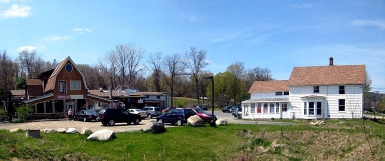
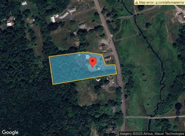
Property Record
206 Main St, Haydenville, MA 01039
NEARBY LISTINGS FOR SALE OR LEASE
-
-
View all Haydenville listings for sale on LoopNet.com
Property Detail
206 Main St
Springfield, MA
Hampshire
WILL-000011K-000000-002710
Massachusetts
Storebuilding
2710
2024
2.99 AC
2024
Hampshire County
822607
Hartford
11,311 SF
DEMOGRAPHICS near 206 Main St
1 Mile
3 Mile
5 Mile
2024 Total Population
1,135
8,424
30,196
2029 Population
880
6,617
24,161
Pop Growth 2024-2029
(22.47%)
(21.45%)
(19.99%)
Average Age
51
49
44
2024 Total Households
468
3,766
12,863
HH Growth 2024-2029
(23.08%)
(22.36%)
(21.89%)
Median Household Inc
$96,268
$78,271
$76,896
Avg Household Size
2.20
2.10
2.10
2024 Avg HH Vehicles
2.00
2.00
2.00
Median Home Value
$404,938
$381,373
$389,698
Median Year Built
1967
1958
1956
Nearby Places
- Restaurants
- Banks
- Shops
- Fitness
- Groceries
PUBLIC TRANSPORTATION
COMMUTER RAIL
Northampton (Valley Flyer - Amtrak, Vermonter - Amtrak)
DRIVE
WALK
Distance
Northampton (Valley Flyer - Amtrak, Vermonter - Amtrak)
12 min
5.7 mi
AIRPORT
Bradley International
DRIVE
WALK
Distance
Bradley International
64 min
35.3 mi
Freight Ports
Albany, NY Port
DRIVE
WALK
Distance
Albany, NY Port
120 min
92.0 mi
Nearby Properties
Address
Land Use
TOTAL SIZE
Lot Size
Zoning
Address
Land Use
TOTAL SIZE
Lot Size
Zoning
143,471 SF
22.12 AC
URA
Address
Land Use
TOTAL SIZE
Lot Size
Zoning
26.50 AC
URB
Address
Land Use
TOTAL SIZE
Lot Size
Zoning
77,732 SF
10.51 AC
SR
Address
Land Use
TOTAL SIZE
Lot Size
Zoning
131.99 AC
HB
Address
Land Use
TOTAL SIZE
Lot Size
Zoning
103.56 AC
SR
Address
Land Use
TOTAL SIZE
Lot Size
Zoning
4.73 AC
URA
Address
Land Use
TOTAL SIZE
Lot Size
Zoning
11.51 AC
SR
Address
Land Use
TOTAL SIZE
Lot Size
Zoning
34,000 SF
7.60 AC
Address
Land Use
TOTAL SIZE
Lot Size
Zoning
55,644 SF
5.20 AC
BUS
Address
Land Use
TOTAL SIZE
Lot Size
Zoning
36,263 SF
1.49 AC
GB
Address
Land Use
TOTAL SIZE
Lot Size
Zoning
2.88 AC
URB
Address
Land Use
TOTAL SIZE
Lot Size
Zoning
49,757 SF
11.07 AC
SR
Address
Land Use
TOTAL SIZE
Lot Size
Zoning
40,072 SF
0.58 AC
GB
Address
Land Use
TOTAL SIZE
Lot Size
Zoning
22,936 SF
5.13 AC
B
Address
Land Use
TOTAL SIZE
Lot Size
Zoning
58,439 SF
2.97 AC
LGT
Address
Land Use
TOTAL SIZE
Lot Size
Zoning
73,696 SF
3.84 AC
GI
Address
Land Use
TOTAL SIZE
Lot Size
Zoning
18,248 SF
1.66 AC
GB
Address
Land Use
TOTAL SIZE
Lot Size
Zoning
27,865 SF
0.75 AC
GB
Address
Land Use
TOTAL SIZE
Lot Size
Zoning
34.39 AC
RR
Address
Land Use
TOTAL SIZE
Lot Size
Zoning
3.35 AC
SI
Address
Land Use
TOTAL SIZE
Lot Size
Zoning
5.50 AC
URB
Address
Land Use
TOTAL SIZE
Lot Size
Zoning
1.98 AC
URB
Address
Land Use
TOTAL SIZE
Lot Size
Zoning
23,460 SF
8.61 AC
B
Address
Land Use
TOTAL SIZE
Lot Size
Zoning
1.36 AC
SI
Address
Land Use
TOTAL SIZE
Lot Size
Zoning
79,786 SF
11.72 AC
GI
Address
Land Use
TOTAL SIZE
Lot Size
Zoning
15.06 AC
RR
Address
Land Use
TOTAL SIZE
Lot Size
Zoning
30.87 AC
SI
Address
Land Use
TOTAL SIZE
Lot Size
Zoning
106.70 AC
RR
Address
Land Use
TOTAL SIZE
Lot Size
Zoning
28,091 SF
2.20 AC
GI
Address
Land Use
TOTAL SIZE
Lot Size
Zoning
15,808 SF
3 AC
SR
The World's #1 Commercial Real Estate Marketplace
Connect with us
© 2025 CoStar Group
The information above has been obtained from sources believed reliable. While we do not doubt its accuracy we have not verified it and make no guarantee, warranty or representation about it. It is your responsibility to independently confirm its accuracy and completeness. Any projections, opinions, assumptions, or estimates used are for example only and do not represent the current or future performance of the property. The value of this transaction to you depends on tax and other factors which should be evaluated by your tax, financial, and legal advisors. You and your advisors should conduct a careful, independent investigation of the property to determine to your satisfaction the suitability of the property for your needs.