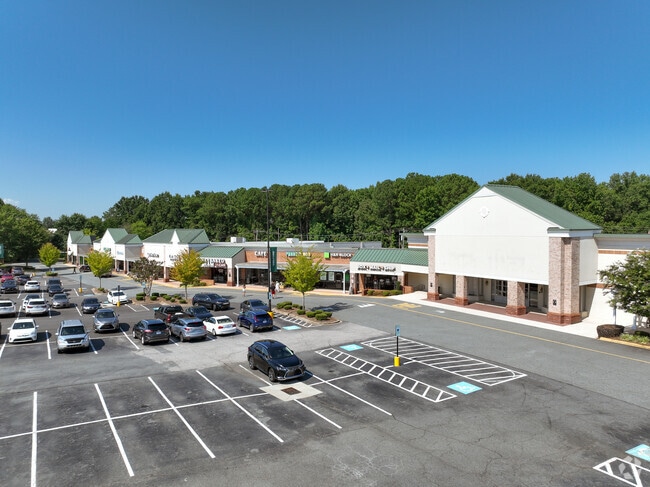
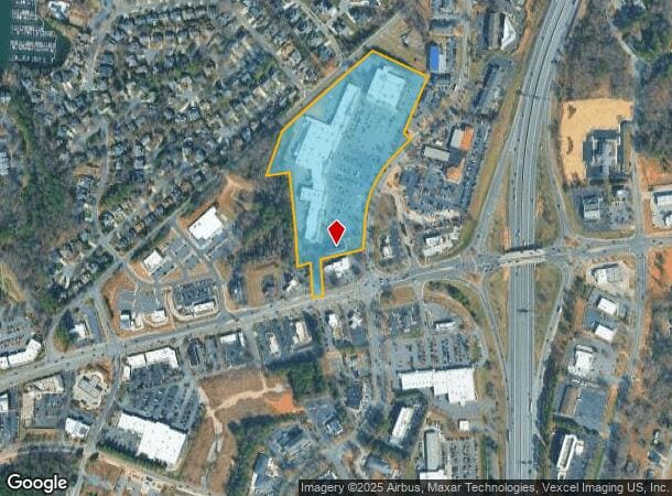
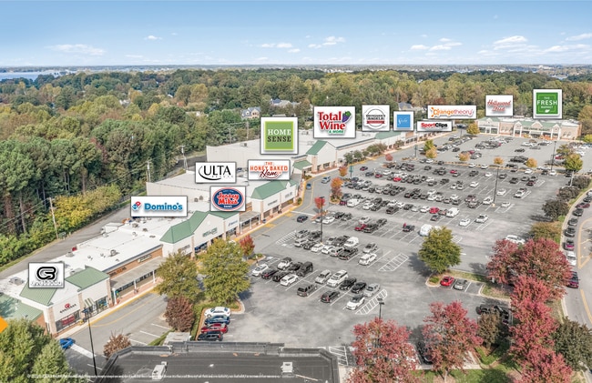
Property Record
20545 Torrence Chapel Rd, Cornelius, NC 28031
NEARBY LISTINGS FOR SALE OR LEASE
Property Detail
20545 Torrence Chapel Rd
Charlotte-Concord-Gastonia, NC-SC
Record Plat Property Of Okee Properties
001-145-08
SEE 114508
Commercialnec
Mecklenburg
X
North Carolina
3710464300K
8
2024
14.37 AC
2025
North
006217
Charlotte
139,665 SF
DEMOGRAPHICS near 20545 Torrence Chapel Rd
1 Mile
3 Mile
5 Mile
2024 Total Population
7,473
44,872
86,833
2029 Population
7,890
47,492
92,810
Pop Growth 2024-2029
+ 5.58%
+ 5.84%
+ 6.88%
Average Age
41
42
41
2024 Total Households
3,291
19,092
34,560
HH Growth 2024-2029
+ 5.56%
+ 5.98%
+ 6.98%
Median Household Inc
$95,655
$105,304
$113,623
Avg Household Size
2.30
2.30
2.40
2024 Avg HH Vehicles
2.00
2.00
2.00
Median Home Value
$480,857
$451,816
$465,845
Median Year Built
1994
1999
2000
Nearby Places
Map Layers
Map Styles
 Street
 Aerial
- Restaurants
- Banks
- Shops
- Fitness
- Groceries
PUBLIC TRANSPORTATION
AIRPORT
Concord-Padgett Regional
DRIVE
WALK
Distance
Concord-Padgett Regional
25 min
17.3 mi
Charlotte/Douglas International
DRIVE
WALK
Distance
Charlotte/Douglas International
36 min
25.4 mi
SALE & LEASE HISTORY
LISTING DATE
SALE/LEASE

Sep 25, 2016
For Lease
Oct 26, 2017
For Lease
Oct 18, 2018
For Lease
Nov 17, 2020
For Lease
Jul 31, 2017
For Lease
Nearby Properties
Address
Land Use
TOTAL SIZE
Lot Size
Zoning
Address
Land Use
TOTAL SIZE
Lot Size
Zoning
1,664,047 SF
221.21 AC
CC
Address
Land Use
TOTAL SIZE
Lot Size
Zoning
395,706 SF
23.38 AC
NRCD
Address
Land Use
TOTAL SIZE
Lot Size
Zoning
569,776 SF
49.01 AC
VIP
Address
Land Use
TOTAL SIZE
Lot Size
Zoning
4,552 SF
92.49 AC
HC(CD)
Address
Land Use
TOTAL SIZE
Lot Size
Zoning
320,754 SF
40.55 AC
NR
Address
Land Use
TOTAL SIZE
Lot Size
Zoning
222,382 SF
31.89 AC
NR
Address
Land Use
TOTAL SIZE
Lot Size
Zoning
339,268 SF
21.80 AC
NR
Address
Land Use
TOTAL SIZE
Lot Size
Zoning
223,720 SF
18.42 AC
VC
Address
Land Use
TOTAL SIZE
Lot Size
Zoning
187,250 SF
22.35 AC
NR
Address
Land Use
TOTAL SIZE
Lot Size
Zoning
292,144 SF
25.33 AC
NRCD
Address
Land Use
TOTAL SIZE
Lot Size
Zoning
245,990 SF
5.21 AC
Address
Land Use
TOTAL SIZE
Lot Size
Zoning
360,243 SF
26.30 AC
HCCD
Address
Land Use
TOTAL SIZE
Lot Size
Zoning
200,768 SF
3.86 AC
HCCD
Address
Land Use
TOTAL SIZE
Lot Size
Zoning
239,596 SF
19.24 AC
NMX
Address
Land Use
TOTAL SIZE
Lot Size
Zoning
163,432 SF
3.40 AC
LPA
Address
Land Use
TOTAL SIZE
Lot Size
Zoning
166,340 SF
14.67 AC
C
Address
Land Use
TOTAL SIZE
Lot Size
Zoning
139,697 SF
19.75 AC
NR
Address
Land Use
TOTAL SIZE
Lot Size
Zoning
194,079 SF
10.03 AC
LPA
Address
Land Use
TOTAL SIZE
Lot Size
Zoning
14,824 SF
5.76 AC
CM
Address
Land Use
TOTAL SIZE
Lot Size
Zoning
204,216 SF
3.29 AC
HCCD
Address
Land Use
TOTAL SIZE
Lot Size
Zoning
180,542 SF
3.50 AC
HCCD
Address
Land Use
TOTAL SIZE
Lot Size
Zoning
Address
Land Use
TOTAL SIZE
Lot Size
Zoning
109,316 SF
7.03 AC
NR
Address
Land Use
TOTAL SIZE
Lot Size
Zoning
107,528 SF
6.90 AC
HCCD
Address
Land Use
TOTAL SIZE
Lot Size
Zoning
85,617 SF
12.36 AC
VC
Address
Land Use
TOTAL SIZE
Lot Size
Zoning
96,656 SF
2.45 AC
CZ(MPD)
Address
Land Use
TOTAL SIZE
Lot Size
Zoning
127,743 SF
3.95 AC
VC(CD)
Address
Land Use
TOTAL SIZE
Lot Size
Zoning
81,162 SF
41.09 AC
NR
Address
Land Use
TOTAL SIZE
Lot Size
Zoning
72,450 SF
14.50 AC
C
The World's #1 Commercial Real Estate Marketplace
Connect with us
© 2026 CoStar Group
The information above has been obtained from sources believed reliable. While we do not doubt its accuracy we have not verified it and make no guarantee, warranty or representation about it. It is your responsibility to independently confirm its accuracy and completeness. Any projections, opinions, assumptions, or estimates used are for example only and do not represent the current or future performance of the property. The value of this transaction to you depends on tax and other factors which should be evaluated by your tax, financial, and legal advisors. You and your advisors should conduct a careful, independent investigation of the property to determine to your satisfaction the suitability of the property for your needs.