Property Record
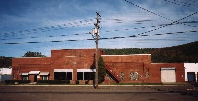
2062 Lesky Rd, Horseheads, NY 14845
NEARBY LISTINGS FOR SALE OR LEASE
Property Detail
2062 Lesky Rd
Elmira, NY
FELL FARM LOTS 21 22 37 38
073489-079-007-0001-019-000-0000
Chemung
Gasolinefuelbulkstorage
New York
2023
19.000
2023
2.30 AC
010400
Other Market Areas
16,500 SF
DEMOGRAPHICS near 2062 Lesky Rd
1 Mile
3 Mile
5 Mile
2024 Total Population
3,600
27,454
58,606
2029 Population
3,479
26,931
57,191
Pop Growth 2024-2029
(3.36%)
(1.91%)
(2.41%)
Average Age
42
40
42
2024 Total Households
1,669
11,826
25,217
HH Growth 2024-2029
(3.59%)
(1.95%)
(2.53%)
Median Household Inc
$51,782
$44,988
$56,417
Avg Household Size
2.10
2.10
2.20
2024 Avg HH Vehicles
2.00
1.00
2.00
Median Home Value
$91,132
$88,420
$116,158
Median Year Built
1947
1948
1951
Nearby Places
- Restaurants
- Banks
- Shops
- Fitness
- Groceries
PUBLIC TRANSPORTATION
AIRPORT
Elmira/Corning Regional
Drive
Walk
Distance
Elmira/Corning Regional
13 min
8.3 mi
Freight Ports
Albany, NY Port
Drive
Walk
Distance
Albany, NY Port
236 min
196.8 mi
Nearby Properties
Address
Land Use
TOTAL SIZE
Lot Size
Zoning
Address
Land Use
TOTAL SIZE
Lot Size
Zoning
59 AC
UNZONED
Address
Land Use
TOTAL SIZE
Lot Size
Zoning
118475
0.70 AC
LAC2
Address
Land Use
TOTAL SIZE
Lot Size
Zoning
308479
28.20 AC
HA
Address
Land Use
TOTAL SIZE
Lot Size
Zoning
290934
13.50 AC
HED
Address
Land Use
TOTAL SIZE
Lot Size
Zoning
271462
7.50 AC
HS
Address
Land Use
TOTAL SIZE
Lot Size
Zoning
160.74 AC
AR
Address
Land Use
TOTAL SIZE
Lot Size
Zoning
60899
207.30 AC
TH02
Address
Land Use
TOTAL SIZE
Lot Size
Zoning
31140
13.50 AC
HA
Address
Land Use
TOTAL SIZE
Lot Size
Zoning
Address
Land Use
TOTAL SIZE
Lot Size
Zoning
Address
Land Use
TOTAL SIZE
Lot Size
Zoning
25388
58.90 AC
RAA
Address
Land Use
TOTAL SIZE
Lot Size
Zoning
18.61 AC
IB
Address
Land Use
TOTAL SIZE
Lot Size
Zoning
52628
2.40 AC
HED
Address
Land Use
TOTAL SIZE
Lot Size
Zoning
103764
31.98 AC
R2
Address
Land Use
TOTAL SIZE
Lot Size
Zoning
55376
32.80 AC
VH02
Address
Land Use
TOTAL SIZE
Lot Size
Zoning
9072
7.13 AC
VH04
Address
Land Use
TOTAL SIZE
Lot Size
Zoning
61157
1 AC
CBD
Address
Land Use
TOTAL SIZE
Lot Size
Zoning
99188
16.80 AC
R2
Address
Land Use
TOTAL SIZE
Lot Size
Zoning
136977
2.55 AC
HED
Address
Land Use
TOTAL SIZE
Lot Size
Zoning
194626
10.20 AC
RAA
Address
Land Use
TOTAL SIZE
Lot Size
Zoning
248126
20.60 AC
VH05
Address
Land Use
TOTAL SIZE
Lot Size
Zoning
5562
22.64 AC
RD
Address
Land Use
TOTAL SIZE
Lot Size
Zoning
420041
46.55 AC
VH08
Address
Land Use
TOTAL SIZE
Lot Size
Zoning
14.10 AC
M
Address
Land Use
TOTAL SIZE
Lot Size
Zoning
130248
7.10 AC
HA
Address
Land Use
TOTAL SIZE
Lot Size
Zoning
82385
18.38 AC
BE
Address
Land Use
TOTAL SIZE
Lot Size
Zoning
13468
4.07 AC
TH04
Address
Land Use
TOTAL SIZE
Lot Size
Zoning
100493
29.47 AC
VH08
Address
Land Use
TOTAL SIZE
Lot Size
Zoning
52122
1.45 AC
HA
Address
Land Use
TOTAL SIZE
Lot Size
Zoning
411352
12.39 AC
VH08
Start a new search to find other properties for sale or lease
Connect with us
© 2024 CoStar Group
The information above has been obtained from sources believed reliable. While we do not doubt its accuracy we have not verified it and make no guarantee, warranty or representation about it. It is your responsibility to independently confirm its accuracy and completeness. Any projections, opinions, assumptions, or estimates used are for example only and do not represent the current or future performance of the property. The value of this transaction to you depends on tax and other factors which should be evaluated by your tax, financial, and legal advisors. You and your advisors should conduct a careful, independent investigation of the property to determine to your satisfaction the suitability of the property for your needs.