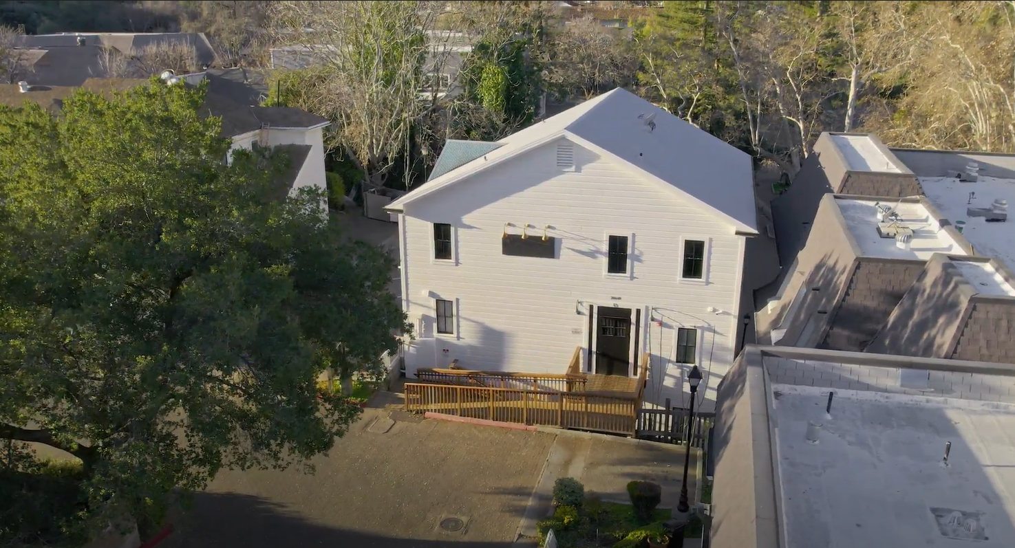
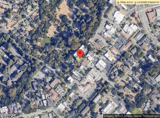
Property Record
20640 3Rd St, Saratoga, CA 95070


NEARBY LISTINGS FOR SALE OR LEASE
Property Detail
20640 3Rd St
503-24-087
Plan Of The Town Of Mccartysville
Financialbuilding
Santa Clara
X
California
06087C0050E
0.05 AC
2023
Los Gatos/Saratoga
2023
South Bay/San Jose
507302
San Jose-Sunnyvale-Santa Clara, CA
7,262 SF
DEMOGRAPHICS near 20640 3Rd St
1 Mile
3 Mile
5 Mile
2024 Total Population
6,883
45,602
194,504
2029 Population
6,604
43,763
186,742
Pop Growth 2024-2029
(4.05%)
(4.03%)
(3.99%)
Average Age
47
46
42
2024 Total Households
2,361
15,745
68,251
HH Growth 2024-2029
(4.36%)
(4.29%)
(4.27%)
Median Household Inc
$240,863
$228,497
$188,752
Avg Household Size
2.90
2.90
2.80
2024 Avg HH Vehicles
3.00
2.00
2.00
Median Home Value
$1,143,478
$1,143,351
$1,139,464
Median Year Built
1967
1966
1967
Nearby Places
- Restaurants
- Banks
- Shops
- Fitness
- Groceries
PUBLIC TRANSPORTATION
COMMUTER RAIL
Sunnyvale (Caltrain - Caltrain (Caltrain))
DRIVE
WALK
Distance
Sunnyvale (Caltrain - Caltrain (Caltrain))
19 min
8.8 mi
Lawrence (Caltrain - Caltrain (Caltrain))
DRIVE
WALK
Distance
Lawrence (Caltrain - Caltrain (Caltrain))
18 min
9.5 mi
AIRPORT
Norman Y Mineta San Jose International
DRIVE
WALK
Distance
Norman Y Mineta San Jose International
22 min
9.9 mi
Freight Ports
Port of Redwood City
DRIVE
WALK
Distance
Port of Redwood City
32 min
22.4 mi
SALE & LEASE HISTORY
LISTING DATE
SALE/LEASE

Nov 27, 2017
For Lease
Aug 13, 2024
For Lease
Apr 28, 2023
For Lease
Apr 27, 2022
For Lease
Nearby Properties
Address
Land Use
TOTAL SIZE
Lot Size
Zoning
Address
Land Use
TOTAL SIZE
Lot Size
Zoning
194,494 SF
25.03 AC
R140
Address
Land Use
TOTAL SIZE
Lot Size
Zoning
124,360 SF
10.48 AC
R140
Address
Land Use
TOTAL SIZE
Lot Size
Zoning
89,262 SF
10.25 AC
PA
Address
Land Use
TOTAL SIZE
Lot Size
Zoning
20,825 SF
6.24 AC
CN
Address
Land Use
TOTAL SIZE
Lot Size
Zoning
4,939 SF
0.80 AC
CP
Address
Land Use
TOTAL SIZE
Lot Size
Zoning
194 AC
HS-D1
Address
Land Use
TOTAL SIZE
Lot Size
Zoning
33,586 SF
0.67 AC
CC
Address
Land Use
TOTAL SIZE
Lot Size
Zoning
2.87 AC
R110
Address
Land Use
TOTAL SIZE
Lot Size
Zoning
43.92 AC
RHSG1
Address
Land Use
TOTAL SIZE
Lot Size
Zoning
26,596 SF
2.24 AC
C1
Address
Land Use
TOTAL SIZE
Lot Size
Zoning
4.83 AC
R120
Address
Land Use
TOTAL SIZE
Lot Size
Zoning
104,526 SF
3.26 AC
C
Address
Land Use
TOTAL SIZE
Lot Size
Zoning
38,760 SF
10.65 AC
R140
Address
Land Use
TOTAL SIZE
Lot Size
Zoning
30,000 SF
2.70 AC
C1
Address
Land Use
TOTAL SIZE
Lot Size
Zoning
23,673 SF
1.24 AC
C1
Address
Land Use
TOTAL SIZE
Lot Size
Zoning
11.31 AC
R120
Address
Land Use
TOTAL SIZE
Lot Size
Zoning
4.56 AC
R1
Address
Land Use
TOTAL SIZE
Lot Size
Zoning
11,722 SF
0.39 AC
CC
Address
Land Use
TOTAL SIZE
Lot Size
Zoning
10.10 AC
LG
Address
Land Use
TOTAL SIZE
Lot Size
Zoning
37.81 AC
AW
Address
Land Use
TOTAL SIZE
Lot Size
Zoning
8,004 SF
45.29 AC
HCRD
Address
Land Use
TOTAL SIZE
Lot Size
Zoning
1.70 AC
C
Address
Land Use
TOTAL SIZE
Lot Size
Zoning
11,648 SF
1.34 AC
C1H
Address
Land Use
TOTAL SIZE
Lot Size
Zoning
11,026 SF
2.93 AC
CN
Address
Land Use
TOTAL SIZE
Lot Size
Zoning
7,000 SF
0.86 AC
CP
Address
Land Use
TOTAL SIZE
Lot Size
Zoning
1.55 AC
SA
Address
Land Use
TOTAL SIZE
Lot Size
Zoning
21,544 SF
0.64 AC
CC
Address
Land Use
TOTAL SIZE
Lot Size
Zoning
18,578 SF
1.13 AC
C
Address
Land Use
TOTAL SIZE
Lot Size
Zoning
12,777 SF
1.33 AC
C
Address
Land Use
TOTAL SIZE
Lot Size
Zoning
3,535 SF
0.35 AC
CN
The World's #1 Commercial Real Estate Marketplace
Connect with us
© 2025 CoStar Group
The information above has been obtained from sources believed reliable. While we do not doubt its accuracy we have not verified it and make no guarantee, warranty or representation about it. It is your responsibility to independently confirm its accuracy and completeness. Any projections, opinions, assumptions, or estimates used are for example only and do not represent the current or future performance of the property. The value of this transaction to you depends on tax and other factors which should be evaluated by your tax, financial, and legal advisors. You and your advisors should conduct a careful, independent investigation of the property to determine to your satisfaction the suitability of the property for your needs.