Property Record
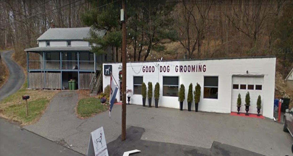
2070 Route 31, Glen Gardner, NJ 08826


NEARBY LISTINGS FOR SALE OR LEASE
-
-
View all Glen Gardner listings for sale on LoopNet.com
Property Detail
2070 Route 31
19-00008-0000-00015-01
Hunterdon
Commercialnec
New Jersey
X
15.1
34019C0116F
0.50 AC
2023
Route 78 West
2024
Northern New Jersey
010201
Newark, NJ-PA
1,026 SF
DEMOGRAPHICS near 2070 Route 31
1 Mile
3 Mile
5 Mile
2024 Total Population
920
11,897
31,265
2029 Population
934
12,058
31,687
Pop Growth 2024-2029
+ 1.52%
+ 1.35%
+ 1.35%
Average Age
43
43
43
2024 Total Households
341
4,591
11,548
HH Growth 2024-2029
+ 1.47%
+ 1.48%
+ 1.65%
Median Household Inc
$131,875
$107,872
$115,837
Avg Household Size
2.60
2.40
2.50
2024 Avg HH Vehicles
2.00
2.00
2.00
Median Home Value
$423,729
$353,605
$393,034
Median Year Built
1980
1973
1977
Nearby Places
- Restaurants
- Banks
- Shops
- Fitness
- Groceries
PUBLIC TRANSPORTATION
COMMUTER RAIL
High Bridge (Raritan Valley Line - NJ Transit Commuter Rail (NJ Transit))
DRIVE
WALK
Distance
High Bridge (Raritan Valley Line - NJ Transit Commuter Rail (NJ Transit))
7 min
3.6 mi
Annandale (Raritan Valley Line - NJ Transit Commuter Rail (NJ Transit))
DRIVE
WALK
Distance
Annandale (Raritan Valley Line - NJ Transit Commuter Rail (NJ Transit))
12 min
6.4 mi
AIRPORT
Lehigh Valley International
DRIVE
WALK
Distance
Lehigh Valley International
44 min
38.6 mi
Newark Liberty International
DRIVE
WALK
Distance
Newark Liberty International
48 min
46.7 mi
SALE & LEASE HISTORY
LISTING DATE
SALE/LEASE

Sep 24, 2016
For Sale
Mar 23, 2020
For Sale
Jun 16, 2020
For Sale
Nearby Properties
Address
Land Use
TOTAL SIZE
Lot Size
Zoning
Address
Land Use
TOTAL SIZE
Lot Size
Zoning
52.10 AC
PCOS
Address
Land Use
TOTAL SIZE
Lot Size
Zoning
1,740.74 AC
INS
Address
Land Use
TOTAL SIZE
Lot Size
Zoning
500.58 AC
WM
Address
Land Use
TOTAL SIZE
Lot Size
Zoning
56.97 AC
R3
Address
Land Use
TOTAL SIZE
Lot Size
Zoning
255.40 AC
WM
Address
Land Use
TOTAL SIZE
Lot Size
Zoning
215.75 AC
RC
Address
Land Use
TOTAL SIZE
Lot Size
Zoning
2,526 SF
339.93 AC
RC
Address
Land Use
TOTAL SIZE
Lot Size
Zoning
Address
Land Use
TOTAL SIZE
Lot Size
Zoning
1,120 SF
103 AC
INS
Address
Land Use
TOTAL SIZE
Lot Size
Zoning
52,594 SF
4.58 AC
GA
Address
Land Use
TOTAL SIZE
Lot Size
Zoning
34.80 AC
ROM
Address
Land Use
TOTAL SIZE
Lot Size
Zoning
2,544 SF
562.37 AC
RC
Address
Land Use
TOTAL SIZE
Lot Size
Zoning
6.87 AC
C
Address
Land Use
TOTAL SIZE
Lot Size
Zoning
32.98 AC
INS
Address
Land Use
TOTAL SIZE
Lot Size
Zoning
25,440 SF
6.06 AC
B2
Address
Land Use
TOTAL SIZE
Lot Size
Zoning
22.94 AC
R-2
Address
Land Use
TOTAL SIZE
Lot Size
Zoning
5,752 SF
2.09 AC
RA
Address
Land Use
TOTAL SIZE
Lot Size
Zoning
73.40 AC
G
Address
Land Use
TOTAL SIZE
Lot Size
Zoning
4,200 SF
30.40 AC
C1
Address
Land Use
TOTAL SIZE
Lot Size
Zoning
2.20 AC
R-4
Address
Land Use
TOTAL SIZE
Lot Size
Zoning
7.91 AC
C1
Address
Land Use
TOTAL SIZE
Lot Size
Zoning
15,600 SF
6.18 AC
C1
Address
Land Use
TOTAL SIZE
Lot Size
Zoning
3 AC
B-2
Address
Land Use
TOTAL SIZE
Lot Size
Zoning
4,443 SF
5.43 AC
MUC
Address
Land Use
TOTAL SIZE
Lot Size
Zoning
7,640 SF
1.87 AC
R1.5
Address
Land Use
TOTAL SIZE
Lot Size
Zoning
3.10 AC
C
Address
Land Use
TOTAL SIZE
Lot Size
Zoning
8.97 AC
Address
Land Use
TOTAL SIZE
Lot Size
Zoning
11,220 SF
4.06 AC
GA
Address
Land Use
TOTAL SIZE
Lot Size
Zoning
35 AC
I
Address
Land Use
TOTAL SIZE
Lot Size
Zoning
0.81 AC
DB
The World's #1 Commercial Real Estate Marketplace
Connect with us
© 2025 CoStar Group
The information above has been obtained from sources believed reliable. While we do not doubt its accuracy we have not verified it and make no guarantee, warranty or representation about it. It is your responsibility to independently confirm its accuracy and completeness. Any projections, opinions, assumptions, or estimates used are for example only and do not represent the current or future performance of the property. The value of this transaction to you depends on tax and other factors which should be evaluated by your tax, financial, and legal advisors. You and your advisors should conduct a careful, independent investigation of the property to determine to your satisfaction the suitability of the property for your needs.