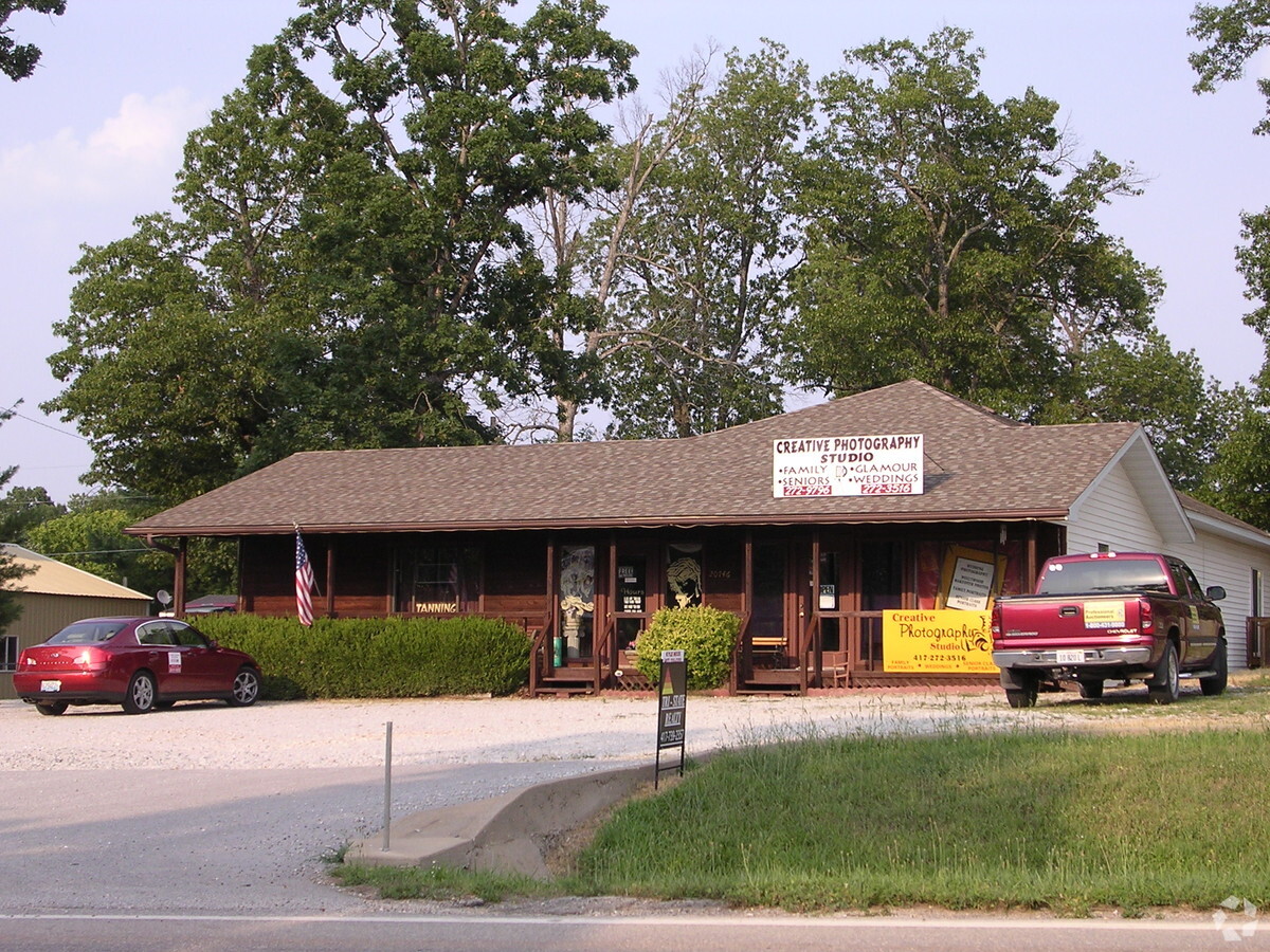
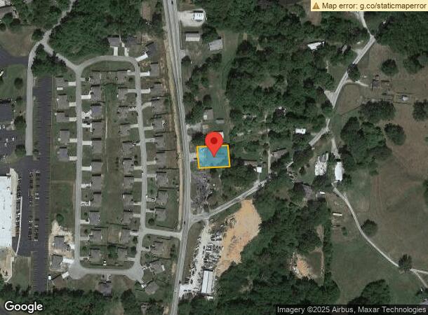
Property Record
20746 State Highway 413, Reeds Spring, MO 65737
NEARBY LISTINGS FOR SALE OR LEASE
-
-
View all Reeds Spring listings for sale on LoopNet.com
Property Detail
20746 State Highway 413
Branson, MO
High 13
11-1.0-02-000-000-004.000
HIGH 13 LOT 6
Stripcommercialcenter
Stone
X
Missouri
29209C0182D
6
2023
0.30 AC
2023
Branson
090605
Other Market Areas
2,520 SF
DEMOGRAPHICS near 20746 State Highway 413
1 Mile
3 Mile
5 Mile
2024 Total Population
753
2,385
6,115
2029 Population
803
2,550
6,637
Pop Growth 2024-2029
+ 6.64%
+ 6.92%
+ 8.54%
Average Age
42
43
46
2024 Total Households
299
944
2,503
HH Growth 2024-2029
+ 5.69%
+ 6.14%
+ 8.03%
Median Household Inc
$37,934
$39,483
$53,537
Avg Household Size
2.50
2.50
2.30
2024 Avg HH Vehicles
2.00
2.00
2.00
Median Home Value
$142,948
$151,867
$194,405
Median Year Built
1990
1990
1995
Nearby Places
- Restaurants
- Banks
- Shops
- Fitness
- Groceries
Nearby Properties
Address
Land Use
TOTAL SIZE
Lot Size
Zoning
Address
Land Use
TOTAL SIZE
Lot Size
Zoning
108,452 SF
47.84 AC
A-1
Address
Land Use
TOTAL SIZE
Lot Size
Zoning
151,500 SF
18.72 AC
NA
Address
Land Use
TOTAL SIZE
Lot Size
Zoning
6,000 SF
11.93 AC
NA
Address
Land Use
TOTAL SIZE
Lot Size
Zoning
51,641 SF
12.80 AC
NA
Address
Land Use
TOTAL SIZE
Lot Size
Zoning
92,520 SF
Address
Land Use
TOTAL SIZE
Lot Size
Zoning
82,388 SF
28.27 AC
NA
Address
Land Use
TOTAL SIZE
Lot Size
Zoning
14,748 SF
1.60 AC
NA
Address
Land Use
TOTAL SIZE
Lot Size
Zoning
15,000 SF
2.32 AC
NA
Address
Land Use
TOTAL SIZE
Lot Size
Zoning
93,998 SF
39 AC
NA
Address
Land Use
TOTAL SIZE
Lot Size
Zoning
46,225 SF
Address
Land Use
TOTAL SIZE
Lot Size
Zoning
25,052 SF
3.98 AC
NA
Address
Land Use
TOTAL SIZE
Lot Size
Zoning
58,746 SF
7.60 AC
NA
Address
Land Use
TOTAL SIZE
Lot Size
Zoning
8,100 SF
1.13 AC
Address
Land Use
TOTAL SIZE
Lot Size
Zoning
8,915 SF
3.27 AC
C-2
Address
Land Use
TOTAL SIZE
Lot Size
Zoning
3,520 SF
1.30 AC
Address
Land Use
TOTAL SIZE
Lot Size
Zoning
5,932 SF
1.87 AC
NA
Address
Land Use
TOTAL SIZE
Lot Size
Zoning
4,403 SF
2.07 AC
NA
Address
Land Use
TOTAL SIZE
Lot Size
Zoning
8,964 SF
1.76 AC
NA
Address
Land Use
TOTAL SIZE
Lot Size
Zoning
6,625 SF
3.83 AC
NA
Address
Land Use
TOTAL SIZE
Lot Size
Zoning
15,039 SF
2 AC
NA
Address
Land Use
TOTAL SIZE
Lot Size
Zoning
9,974 SF
1.05 AC
NA
Address
Land Use
TOTAL SIZE
Lot Size
Zoning
21,100 SF
1.48 AC
NA
Address
Land Use
TOTAL SIZE
Lot Size
Zoning
12,338 SF
7.81 AC
C-2
Address
Land Use
TOTAL SIZE
Lot Size
Zoning
9,000 SF
1.80 AC
NA
Address
Land Use
TOTAL SIZE
Lot Size
Zoning
3,243 SF
6.80 AC
NA
Address
Land Use
TOTAL SIZE
Lot Size
Zoning
5,130 SF
1 AC
NA
Address
Land Use
TOTAL SIZE
Lot Size
Zoning
5,250 SF
4 AC
NA
Address
Land Use
TOTAL SIZE
Lot Size
Zoning
3,605 SF
1.19 AC
NA
Address
Land Use
TOTAL SIZE
Lot Size
Zoning
43,104 SF
5.86 AC
C-2
The World's #1 Commercial Real Estate Marketplace
Connect with us
© 2025 CoStar Group
The information above has been obtained from sources believed reliable. While we do not doubt its accuracy we have not verified it and make no guarantee, warranty or representation about it. It is your responsibility to independently confirm its accuracy and completeness. Any projections, opinions, assumptions, or estimates used are for example only and do not represent the current or future performance of the property. The value of this transaction to you depends on tax and other factors which should be evaluated by your tax, financial, and legal advisors. You and your advisors should conduct a careful, independent investigation of the property to determine to your satisfaction the suitability of the property for your needs.