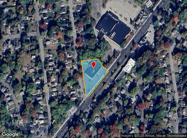
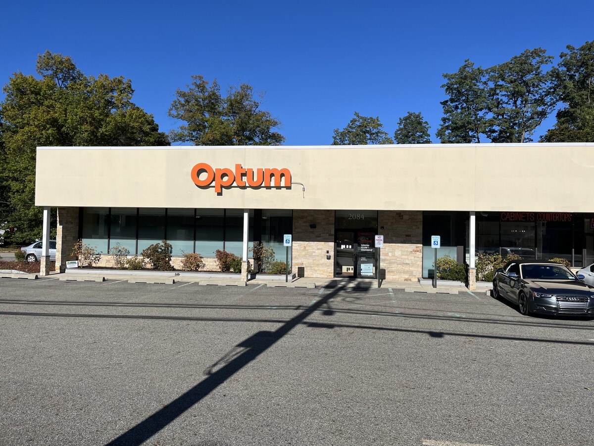
Property Record
20842090 E Main St, Cortlandt Manor, NY 10567


Current Lease Availabilities
NEARBY LISTINGS FOR SALE OR LEASE
Property Detail
20842090 E Main St
New York-Jersey City-White Plains, NY-NJ
7.02-003-001
2289-024-013-00002-000-0010
Westchester
Storesoffices
New York
X
10.000
36119C0017F
1.26 AC
2023
Northwest
2023
Westchester/So Connecticut
014701
DEMOGRAPHICS near 20842090 E Main St
1 Mile
3 Mile
5 Mile
2024 Total Population
6,057
52,664
83,297
2029 Population
5,844
51,342
81,388
Pop Growth 2024-2029
(3.52%)
(2.51%)
(2.29%)
Average Age
43
42
43
2024 Total Households
2,155
18,938
29,772
HH Growth 2024-2029
(3.85%)
(2.69%)
(2.52%)
Median Household Inc
$115,518
$105,686
$117,871
Avg Household Size
2.70
2.70
2.70
2024 Avg HH Vehicles
2.00
2.00
2.00
Median Home Value
$376,752
$397,232
$439,144
Median Year Built
1960
1962
1963
Nearby Places
- Restaurants
- Banks
- Shops
- Fitness
- Groceries
PUBLIC TRANSPORTATION
COMMUTER RAIL
Peekskill Station (Hudson Line - Metro-North Commuter Railroad Company (Metro-North))
DRIVE
WALK
Distance
Peekskill Station (Hudson Line - Metro-North Commuter Railroad Company (Metro-North))
6 min
3.3 mi
Cortlandt Station (Hudson Line - Metro-North Commuter Railroad Company (Metro-North))
DRIVE
WALK
Distance
Cortlandt Station (Hudson Line - Metro-North Commuter Railroad Company (Metro-North))
13 min
6.4 mi
AIRPORT
New York Stewart International
DRIVE
WALK
Distance
New York Stewart International
46 min
26.6 mi
Westchester County
DRIVE
WALK
Distance
Westchester County
38 min
28.0 mi
Freight Ports
NY - Red Hook Container Terminal
DRIVE
WALK
Distance
NY - Red Hook Container Terminal
81 min
55.4 mi
Nearby Properties
Address
Land Use
TOTAL SIZE
Lot Size
Zoning
Address
Land Use
TOTAL SIZE
Lot Size
Zoning
59,267 SF
37.78 AC
R2
Address
Land Use
TOTAL SIZE
Lot Size
Zoning
Address
Land Use
TOTAL SIZE
Lot Size
Zoning
Address
Land Use
TOTAL SIZE
Lot Size
Zoning
13,520 SF
1.16 AC
CC1
Address
Land Use
TOTAL SIZE
Lot Size
Zoning
21,466 SF
2.87 AC
CC1
Address
Land Use
TOTAL SIZE
Lot Size
Zoning
13 AC
R1-40
Address
Land Use
TOTAL SIZE
Lot Size
Zoning
Address
Land Use
TOTAL SIZE
Lot Size
Zoning
82.53 AC
Address
Land Use
TOTAL SIZE
Lot Size
Zoning
2.70 AC
Address
Land Use
TOTAL SIZE
Lot Size
Zoning
240.57 AC
CD
Address
Land Use
TOTAL SIZE
Lot Size
Zoning
4,402 SF
5.38 AC
R2
Address
Land Use
TOTAL SIZE
Lot Size
Zoning
22.61 AC
Address
Land Use
TOTAL SIZE
Lot Size
Zoning
8.93 AC
Address
Land Use
TOTAL SIZE
Lot Size
Zoning
8,834 SF
2.58 AC
CC1
Address
Land Use
TOTAL SIZE
Lot Size
Zoning
Address
Land Use
TOTAL SIZE
Lot Size
Zoning
2.98 AC
Address
Land Use
TOTAL SIZE
Lot Size
Zoning
10,781 SF
9.29 AC
R2
Address
Land Use
TOTAL SIZE
Lot Size
Zoning
7.50 AC
Address
Land Use
TOTAL SIZE
Lot Size
Zoning
6,312 SF
4.86 AC
CC1
Address
Land Use
TOTAL SIZE
Lot Size
Zoning
38.05 AC
Address
Land Use
TOTAL SIZE
Lot Size
Zoning
3,812 SF
0.99 AC
LP
Address
Land Use
TOTAL SIZE
Lot Size
Zoning
2,376 SF
1.41 AC
R1
Address
Land Use
TOTAL SIZE
Lot Size
Zoning
4,664 SF
0.55 AC
CC2
Address
Land Use
TOTAL SIZE
Lot Size
Zoning
3,421 SF
0.91 AC
CC1
Address
Land Use
TOTAL SIZE
Lot Size
Zoning
1,844 SF
0.50 AC
CC1
Address
Land Use
TOTAL SIZE
Lot Size
Zoning
6,976 SF
0.58 AC
CC1
Address
Land Use
TOTAL SIZE
Lot Size
Zoning
3,690 SF
0.50 AC
LP
Address
Land Use
TOTAL SIZE
Lot Size
Zoning
23.27 AC
Address
Land Use
TOTAL SIZE
Lot Size
Zoning
9,498 SF
0.21 AC
R10
Address
Land Use
TOTAL SIZE
Lot Size
Zoning
48.07 AC
The World's #1 Commercial Real Estate Marketplace
Connect with us
© 2025 CoStar Group
The information above has been obtained from sources believed reliable. While we do not doubt its accuracy we have not verified it and make no guarantee, warranty or representation about it. It is your responsibility to independently confirm its accuracy and completeness. Any projections, opinions, assumptions, or estimates used are for example only and do not represent the current or future performance of the property. The value of this transaction to you depends on tax and other factors which should be evaluated by your tax, financial, and legal advisors. You and your advisors should conduct a careful, independent investigation of the property to determine to your satisfaction the suitability of the property for your needs.