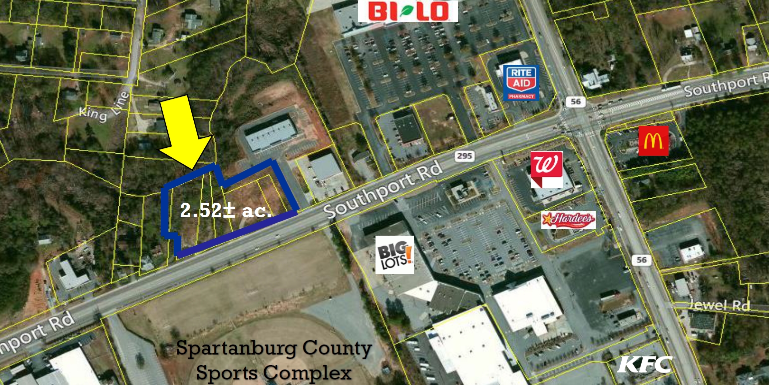
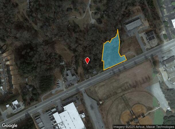
Property Record
2085 Southport Rd, Spartanburg, SC 29306
NEARBY LISTINGS FOR SALE OR LEASE
Property Detail
2085 Southport Rd
Spartanburg, SC
Camp Croft Trading Corp
7-21-02-005.00
TRACT A ASSOCIATED REALTY PARTNERS SURVEY HWY RW TAKEN 42.137B TR 33 DB 124R-785 DB 124R-789 PB 176
Vacantlandnec
Spartanburg
X
South Carolina
45083C0267D
1.39 AC
2024
Lower Spartanburg County
2023
Greenville/Spartanburg
021100
DEMOGRAPHICS near 2085 Southport Rd
1 Mile
3 Mile
5 Mile
2024 Total Population
2,952
29,881
74,044
2029 Population
3,354
33,856
84,074
Pop Growth 2024-2029
+ 13.62%
+ 13.30%
+ 13.55%
Average Age
41
41
40
2024 Total Households
1,234
12,695
30,119
HH Growth 2024-2029
+ 13.78%
+ 13.53%
+ 14.00%
Median Household Inc
$54,545
$49,242
$48,293
Avg Household Size
2.30
2.30
2.30
2024 Avg HH Vehicles
2.00
2.00
2.00
Median Home Value
$155,595
$188,222
$172,345
Median Year Built
1973
1970
1974
Nearby Places
- Restaurants
- Banks
- Shops
- Fitness
- Groceries
PUBLIC TRANSPORTATION
COMMUTER RAIL
Spartanburg Amtrak Station (Crescent - Amtrak)
DRIVE
WALK
Distance
Spartanburg Amtrak Station (Crescent - Amtrak)
10 min
4.3 mi
AIRPORT
Greenville Spartanburg International
DRIVE
WALK
Distance
Greenville Spartanburg International
38 min
23.2 mi
Freight Ports
North Charleston Terminal
DRIVE
WALK
Distance
North Charleston Terminal
220 min
194.1 mi
SALE & LEASE HISTORY
LISTING DATE
SALE/LEASE

Sep 24, 2016
For Sale
Nearby Properties
Address
Land Use
TOTAL SIZE
Lot Size
Zoning
Address
Land Use
TOTAL SIZE
Lot Size
Zoning
7,245 SF
18.10 AC
Address
Land Use
TOTAL SIZE
Lot Size
Zoning
1,782 SF
3.50 AC
Address
Land Use
TOTAL SIZE
Lot Size
Zoning
44,199 SF
5.02 AC
Address
Land Use
TOTAL SIZE
Lot Size
Zoning
2,288 SF
8.10 AC
Address
Land Use
TOTAL SIZE
Lot Size
Zoning
6,879 SF
135.30 AC
Address
Land Use
TOTAL SIZE
Lot Size
Zoning
84,960 SF
0.85 AC
Address
Land Use
TOTAL SIZE
Lot Size
Zoning
66,960 SF
1 AC
Address
Land Use
TOTAL SIZE
Lot Size
Zoning
237.17 AC
Address
Land Use
TOTAL SIZE
Lot Size
Zoning
4,590 SF
10.55 AC
Address
Land Use
TOTAL SIZE
Lot Size
Zoning
2,908 SF
1.51 AC
Address
Land Use
TOTAL SIZE
Lot Size
Zoning
43,638 SF
8.58 AC
Address
Land Use
TOTAL SIZE
Lot Size
Zoning
665 SF
6.31 AC
Address
Land Use
TOTAL SIZE
Lot Size
Zoning
67,876 SF
6.45 AC
Address
Land Use
TOTAL SIZE
Lot Size
Zoning
3,464 SF
0.19 AC
Address
Land Use
TOTAL SIZE
Lot Size
Zoning
2,312 SF
0.34 AC
Address
Land Use
TOTAL SIZE
Lot Size
Zoning
3,456 SF
0.23 AC
Address
Land Use
TOTAL SIZE
Lot Size
Zoning
3,946 SF
0.53 AC
Address
Land Use
TOTAL SIZE
Lot Size
Zoning
2,577 SF
0.19 AC
Address
Land Use
TOTAL SIZE
Lot Size
Zoning
4,272 SF
0.43 AC
Address
Land Use
TOTAL SIZE
Lot Size
Zoning
1,536 SF
11.75 AC
Address
Land Use
TOTAL SIZE
Lot Size
Zoning
3,614 SF
0.46 AC
Address
Land Use
TOTAL SIZE
Lot Size
Zoning
2,310 SF
0.48 AC
Address
Land Use
TOTAL SIZE
Lot Size
Zoning
29,311 SF
2.98 AC
Address
Land Use
TOTAL SIZE
Lot Size
Zoning
25,024 SF
0.31 AC
Address
Land Use
TOTAL SIZE
Lot Size
Zoning
14,736 SF
1.64 AC
Address
Land Use
TOTAL SIZE
Lot Size
Zoning
60,480 SF
7.75 AC
Address
Land Use
TOTAL SIZE
Lot Size
Zoning
19,810 SF
1.67 AC
Address
Land Use
TOTAL SIZE
Lot Size
Zoning
54,752 SF
8.59 AC
Address
Land Use
TOTAL SIZE
Lot Size
Zoning
16.26 AC
Address
Land Use
TOTAL SIZE
Lot Size
Zoning
1,992 SF
0.44 AC
The World's #1 Commercial Real Estate Marketplace
Connect with us
© 2025 CoStar Group
The information above has been obtained from sources believed reliable. While we do not doubt its accuracy we have not verified it and make no guarantee, warranty or representation about it. It is your responsibility to independently confirm its accuracy and completeness. Any projections, opinions, assumptions, or estimates used are for example only and do not represent the current or future performance of the property. The value of this transaction to you depends on tax and other factors which should be evaluated by your tax, financial, and legal advisors. You and your advisors should conduct a careful, independent investigation of the property to determine to your satisfaction the suitability of the property for your needs.