Property Record
2099 Jonesboro Rd Se, Atlanta, GA 30315

NEARBY LISTINGS FOR SALE OR LEASE
Property Detail
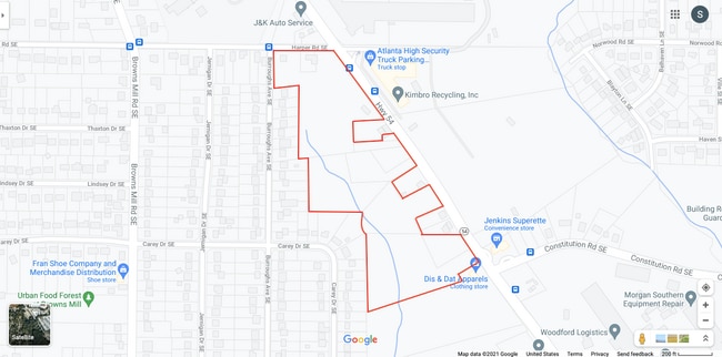
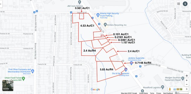
2099 Jonesboro Rd Se
14-0038-0002-047-6
KA PARKING LOT & FLAG POLE CB 25 MONITOR VACANT LOT
Parkinglot
Fulton
X
Georgia
13121C0378F
4.53 AC
2024
North Clayton/Airport
2025
Atlanta
006702
Atlanta-Sandy Springs-Roswell, GA
DEMOGRAPHICS near 2099 Jonesboro Rd Se
1 Mile
3 Mile
5 Mile
2024 Total Population
7,926
72,950
248,292
2029 Population
8,389
76,228
256,387
Pop Growth 2024-2029
+ 5.84%
+ 4.49%
+ 3.26%
Average Age
34
37
37
2024 Total Households
2,724
28,267
104,021
HH Growth 2024-2029
+ 5.87%
+ 4.67%
+ 3.56%
Median Household Inc
$40,302
$52,677
$59,035
Avg Household Size
2.70
2.40
2.20
2024 Avg HH Vehicles
1.00
1.00
1.00
Median Home Value
$175,409
$288,732
$300,272
Median Year Built
1969
1972
1976
Nearby Places
Map Layers
Map Styles
 Street
 Aerial
- Restaurants
- Banks
- Shops
- Fitness
- Groceries
PUBLIC TRANSPORTATION
COMMUTER RAIL
Atlanta (Crescent - Amtrak)
DRIVE
WALK
Distance
Atlanta (Crescent - Amtrak)
14 min
8.8 mi
AIRPORT
Hartsfield - Jackson Atlanta International
DRIVE
WALK
Distance
Hartsfield - Jackson Atlanta International
13 min
7.3 mi
Freight Ports
Georgia Ports - Savannah
DRIVE
WALK
Distance
Georgia Ports - Savannah
273 min
242.9 mi
SALE & LEASE HISTORY
LISTING DATE
SALE/LEASE

May 20, 2021
For Lease
Jan 26, 2023
For Sale
Nearby Properties
Address
Land Use
TOTAL SIZE
Lot Size
Zoning
Address
Land Use
TOTAL SIZE
Lot Size
Zoning
7 AC
C3
Address
Land Use
TOTAL SIZE
Lot Size
Zoning
432,056 SF
17.87 AC
C1
Address
Land Use
TOTAL SIZE
Lot Size
Zoning
498,515 SF
3.41 AC
C1
Address
Land Use
TOTAL SIZE
Lot Size
Zoning
595,658 SF
4.09 AC
I1
Address
Land Use
TOTAL SIZE
Lot Size
Zoning
94.93 AC
R5
Address
Land Use
TOTAL SIZE
Lot Size
Zoning
54 AC
I2
Address
Land Use
TOTAL SIZE
Lot Size
Zoning
436,143 SF
2.90 AC
I1
Address
Land Use
TOTAL SIZE
Lot Size
Zoning
330,125 SF
7.16 AC
I1
Address
Land Use
TOTAL SIZE
Lot Size
Zoning
828,718 SF
2.60 AC
I1
Address
Land Use
TOTAL SIZE
Lot Size
Zoning
1,128,762 SF
10.39 AC
I2
Address
Land Use
TOTAL SIZE
Lot Size
Zoning
293,935 SF
8.47 AC
I2
Address
Land Use
TOTAL SIZE
Lot Size
Zoning
318,300 SF
4.60 AC
I1
Address
Land Use
TOTAL SIZE
Lot Size
Zoning
381,983 SF
52.54 AC
M
Address
Land Use
TOTAL SIZE
Lot Size
Zoning
389,641 SF
2.97 AC
I1
Address
Land Use
TOTAL SIZE
Lot Size
Zoning
313,734 SF
22.60 AC
R5
Address
Land Use
TOTAL SIZE
Lot Size
Zoning
7.65 AC
R5
Address
Land Use
TOTAL SIZE
Lot Size
Zoning
164,664 SF
4.93 AC
I1
Address
Land Use
TOTAL SIZE
Lot Size
Zoning
689,523 SF
34.32 AC
I1
Address
Land Use
TOTAL SIZE
Lot Size
Zoning
1,352,250 SF
3.18 AC
C2
Address
Land Use
TOTAL SIZE
Lot Size
Zoning
375,336 SF
22.76 AC
M
Address
Land Use
TOTAL SIZE
Lot Size
Zoning
1,680 SF
2.45 AC
I2
Address
Land Use
TOTAL SIZE
Lot Size
Zoning
59,807 SF
43.70 AC
X
Address
Land Use
TOTAL SIZE
Lot Size
Zoning
150,899 SF
21.89 AC
X
Address
Land Use
TOTAL SIZE
Lot Size
Zoning
12 AC
R4
Address
Land Use
TOTAL SIZE
Lot Size
Zoning
814,461 SF
29.12 AC
RG2
Address
Land Use
TOTAL SIZE
Lot Size
Zoning
402,544 SF
20.43 AC
I1
Address
Land Use
TOTAL SIZE
Lot Size
Zoning
54.47 AC
OI
Address
Land Use
TOTAL SIZE
Lot Size
Zoning
87,382 SF
83.24 AC
I1C
Address
Land Use
TOTAL SIZE
Lot Size
Zoning
39.06 AC
OI
Address
Land Use
TOTAL SIZE
Lot Size
Zoning
86,071 SF
18 AC
M
The World's #1 Commercial Real Estate Marketplace
Connect with us
© 2026 CoStar Group
The information above has been obtained from sources believed reliable. While we do not doubt its accuracy we have not verified it and make no guarantee, warranty or representation about it. It is your responsibility to independently confirm its accuracy and completeness. Any projections, opinions, assumptions, or estimates used are for example only and do not represent the current or future performance of the property. The value of this transaction to you depends on tax and other factors which should be evaluated by your tax, financial, and legal advisors. You and your advisors should conduct a careful, independent investigation of the property to determine to your satisfaction the suitability of the property for your needs.