Property Record
210 N 1200 E, Lehi, UT 84043
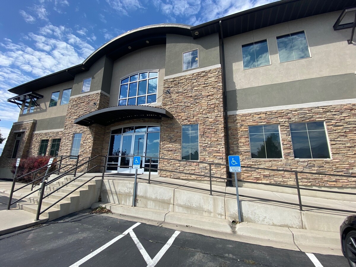


This Property Is For Sale
NEARBY LISTINGS FOR SALE OR LEASE
Property Detail
210 N 1200 E
Salt Lake City
Stonehaven Professional Office Park Comm
Provo-Orem, UT
LOT 4, PLAT A, STONEHAVEN PROFESSIONAL OFFICE PARK COMMERCIAL PUD SUBDV. AREA 0.826 AC
66-121-0004
Utah
Officebuilding
Utah
2024
4
2024
0.83 AC
000207
Utah County
10,677 SF
DEMOGRAPHICS near 210 N 1200 E
1 Mile
3 Mile
5 Mile
2024 Total Population
9,940
86,161
189,706
2029 Population
11,617
100,708
222,961
Pop Growth 2024-2029
+ 16.87%
+ 16.88%
+ 17.53%
Average Age
33
32
31
2024 Total Households
2,834
23,333
52,702
HH Growth 2024-2029
+ 17.29%
+ 17.19%
+ 17.97%
Median Household Inc
$88,464
$107,589
$110,366
Avg Household Size
3.40
3.70
3.60
2024 Avg HH Vehicles
2.00
3.00
2.00
Median Home Value
$507,576
$508,072
$517,174
Median Year Built
1997
2001
2006
Nearby Places
- Restaurants
- Banks
- Shops
- Fitness
- Groceries
PUBLIC TRANSPORTATION
COMMUTER RAIL
American Fork Station (FrontRunner - Utah Transit Authority (UTA))
DRIVE
WALK
Distance
American Fork Station (FrontRunner - Utah Transit Authority (UTA))
6 min
2.7 mi
Lehi Station (FrontRunner - Utah Transit Authority (UTA))
DRIVE
WALK
Distance
Lehi Station (FrontRunner - Utah Transit Authority (UTA))
10 min
5.9 mi
AIRPORT
Provo Municipal
DRIVE
WALK
Distance
Provo Municipal
23 min
17.7 mi
Salt Lake City International
DRIVE
WALK
Distance
Salt Lake City International
40 min
33.9 mi
Freight Ports
Port of Stockton
DRIVE
WALK
Distance
Port of Stockton
740 min
724.3 mi
Nearby Properties
Address
Land Use
TOTAL SIZE
Lot Size
Zoning
Address
Land Use
TOTAL SIZE
Lot Size
Zoning
181,908 SF
1.43 AC
Address
Land Use
TOTAL SIZE
Lot Size
Zoning
124,460 SF
6.46 AC
Address
Land Use
TOTAL SIZE
Lot Size
Zoning
223,967 SF
21.91 AC
Address
Land Use
TOTAL SIZE
Lot Size
Zoning
165,821 SF
12.29 AC
Address
Land Use
TOTAL SIZE
Lot Size
Zoning
83,049 SF
12.07 AC
Address
Land Use
TOTAL SIZE
Lot Size
Zoning
11,389 SF
13.08 AC
Address
Land Use
TOTAL SIZE
Lot Size
Zoning
73,903 SF
7.05 AC
Address
Land Use
TOTAL SIZE
Lot Size
Zoning
115,908 SF
6.68 AC
Address
Land Use
TOTAL SIZE
Lot Size
Zoning
148,812 SF
13.49 AC
Address
Land Use
TOTAL SIZE
Lot Size
Zoning
143,438 SF
7.43 AC
Address
Land Use
TOTAL SIZE
Lot Size
Zoning
46,212 SF
8.97 AC
Address
Land Use
TOTAL SIZE
Lot Size
Zoning
100,814 SF
8.22 AC
Address
Land Use
TOTAL SIZE
Lot Size
Zoning
3,969 SF
8.83 AC
Address
Land Use
TOTAL SIZE
Lot Size
Zoning
32,072 SF
6.47 AC
Address
Land Use
TOTAL SIZE
Lot Size
Zoning
137,193 SF
12.45 AC
Address
Land Use
TOTAL SIZE
Lot Size
Zoning
5,269 SF
8.82 AC
Address
Land Use
TOTAL SIZE
Lot Size
Zoning
76,420 SF
3.94 AC
Address
Land Use
TOTAL SIZE
Lot Size
Zoning
44,854 SF
6.99 AC
Address
Land Use
TOTAL SIZE
Lot Size
Zoning
51,536 SF
2.27 AC
Address
Land Use
TOTAL SIZE
Lot Size
Zoning
124,836 SF
8.74 AC
Address
Land Use
TOTAL SIZE
Lot Size
Zoning
42,332 SF
6.78 AC
Address
Land Use
TOTAL SIZE
Lot Size
Zoning
22,155 SF
7.97 AC
Address
Land Use
TOTAL SIZE
Lot Size
Zoning
100,973 SF
5.71 AC
Address
Land Use
TOTAL SIZE
Lot Size
Zoning
24,705 SF
6.53 AC
Address
Land Use
TOTAL SIZE
Lot Size
Zoning
111,292 SF
5.36 AC
Address
Land Use
TOTAL SIZE
Lot Size
Zoning
70,812 SF
4.07 AC
Address
Land Use
TOTAL SIZE
Lot Size
Zoning
69,517 SF
5.65 AC
Address
Land Use
TOTAL SIZE
Lot Size
Zoning
88,561 SF
9.32 AC
Address
Land Use
TOTAL SIZE
Lot Size
Zoning
97,088 SF
3.88 AC
Address
Land Use
TOTAL SIZE
Lot Size
Zoning
105,188 SF
10.64 AC
The World's #1 Commercial Real Estate Marketplace
Connect with us
© 2025 CoStar Group
The information above has been obtained from sources believed reliable. While we do not doubt its accuracy we have not verified it and make no guarantee, warranty or representation about it. It is your responsibility to independently confirm its accuracy and completeness. Any projections, opinions, assumptions, or estimates used are for example only and do not represent the current or future performance of the property. The value of this transaction to you depends on tax and other factors which should be evaluated by your tax, financial, and legal advisors. You and your advisors should conduct a careful, independent investigation of the property to determine to your satisfaction the suitability of the property for your needs.