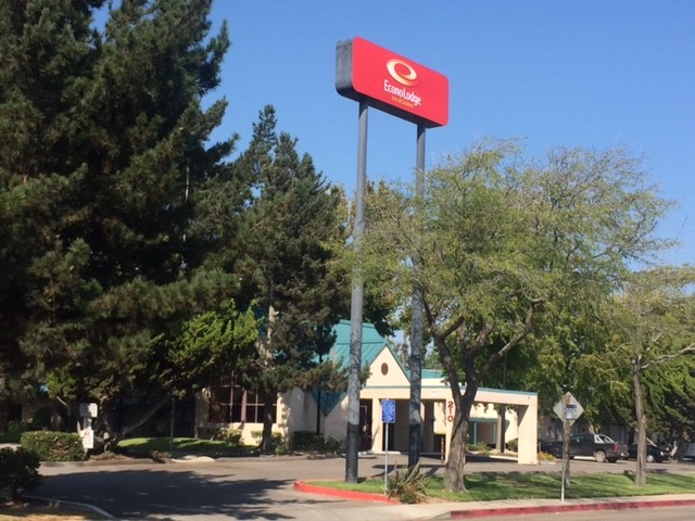
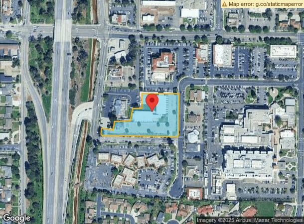
Property Record
210 Nicholson Ave, Santa Maria, CA 93454

NEARBY LISTINGS FOR SALE OR LEASE
-
-
View all Santa Maria listings for sale on LoopNet.com
Property Detail
210 Nicholson Ave
Santa Maria-Santa Barbara, CA
Santa Maria
128-120-009
Santa Barbara
Hotel
California
X
2
06079C1910F
2.10 AC
2023
Santa Barbara/Santa Maria
2023
Santa Barbara/Sta Maria/Goleta
002211
DEMOGRAPHICS near 210 Nicholson Ave
1 Mile
3 Mile
5 Mile
2024 Total Population
17,160
101,796
119,188
2029 Population
16,953
100,947
118,160
Pop Growth 2024-2029
(1.21%)
(0.83%)
(0.86%)
Average Age
36
33
34
2024 Total Households
5,070
26,447
32,398
HH Growth 2024-2029
(1.40%)
(0.92%)
(0.95%)
Median Household Inc
$79,675
$73,551
$77,266
Avg Household Size
3.20
3.60
3.50
2024 Avg HH Vehicles
2.00
2.00
2.00
Median Home Value
$438,909
$414,631
$429,213
Median Year Built
1971
1978
1979
Nearby Places
- Restaurants
- Banks
- Shops
- Fitness
- Groceries
PUBLIC TRANSPORTATION
COMMUTER RAIL
Guadalupe Amtrak Station (Pacific Surfliner - Amtrak)
DRIVE
WALK
Distance
Guadalupe Amtrak Station (Pacific Surfliner - Amtrak)
15 min
9.5 mi
AIRPORT
San Luis County Regional
DRIVE
WALK
Distance
San Luis County Regional
36 min
25.4 mi
Freight Ports
The Port of Hueneme
DRIVE
WALK
Distance
The Port of Hueneme
134 min
102.2 mi
SALE & LEASE HISTORY
LISTING DATE
SALE/LEASE

Sep 24, 2016
For Sale
Jan 02, 2018
For Sale
Aug 30, 2017
For Sale
Nearby Properties
Address
Land Use
TOTAL SIZE
Lot Size
Zoning
Address
Land Use
TOTAL SIZE
Lot Size
Zoning
Address
Land Use
TOTAL SIZE
Lot Size
Zoning
14.45 AC
Address
Land Use
TOTAL SIZE
Lot Size
Zoning
14.93 AC
Address
Land Use
TOTAL SIZE
Lot Size
Zoning
146.75 AC
Address
Land Use
TOTAL SIZE
Lot Size
Zoning
9.46 AC
Address
Land Use
TOTAL SIZE
Lot Size
Zoning
18.19 AC
Address
Land Use
TOTAL SIZE
Lot Size
Zoning
Address
Land Use
TOTAL SIZE
Lot Size
Zoning
9.50 AC
Address
Land Use
TOTAL SIZE
Lot Size
Zoning
17.71 AC
Address
Land Use
TOTAL SIZE
Lot Size
Zoning
10.75 AC
Address
Land Use
TOTAL SIZE
Lot Size
Zoning
Address
Land Use
TOTAL SIZE
Lot Size
Zoning
10.81 AC
Address
Land Use
TOTAL SIZE
Lot Size
Zoning
13.76 AC
Address
Land Use
TOTAL SIZE
Lot Size
Zoning
Address
Land Use
TOTAL SIZE
Lot Size
Zoning
4.40 AC
Address
Land Use
TOTAL SIZE
Lot Size
Zoning
35.87 AC
AGII40
Address
Land Use
TOTAL SIZE
Lot Size
Zoning
27.05 AC
Address
Land Use
TOTAL SIZE
Lot Size
Zoning
2.81 AC
Address
Land Use
TOTAL SIZE
Lot Size
Zoning
6.11 AC
Address
Land Use
TOTAL SIZE
Lot Size
Zoning
Address
Land Use
TOTAL SIZE
Lot Size
Zoning
11.13 AC
Address
Land Use
TOTAL SIZE
Lot Size
Zoning
3.79 AC
Address
Land Use
TOTAL SIZE
Lot Size
Zoning
Address
Land Use
TOTAL SIZE
Lot Size
Zoning
Address
Land Use
TOTAL SIZE
Lot Size
Zoning
Address
Land Use
TOTAL SIZE
Lot Size
Zoning
6.36 AC
Address
Land Use
TOTAL SIZE
Lot Size
Zoning
6.17 AC
Address
Land Use
TOTAL SIZE
Lot Size
Zoning
Address
Land Use
TOTAL SIZE
Lot Size
Zoning
Address
Land Use
TOTAL SIZE
Lot Size
Zoning
3.60 AC
The World's #1 Commercial Real Estate Marketplace
Connect with us
© 2025 CoStar Group
The information above has been obtained from sources believed reliable. While we do not doubt its accuracy we have not verified it and make no guarantee, warranty or representation about it. It is your responsibility to independently confirm its accuracy and completeness. Any projections, opinions, assumptions, or estimates used are for example only and do not represent the current or future performance of the property. The value of this transaction to you depends on tax and other factors which should be evaluated by your tax, financial, and legal advisors. You and your advisors should conduct a careful, independent investigation of the property to determine to your satisfaction the suitability of the property for your needs.