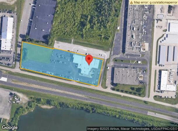
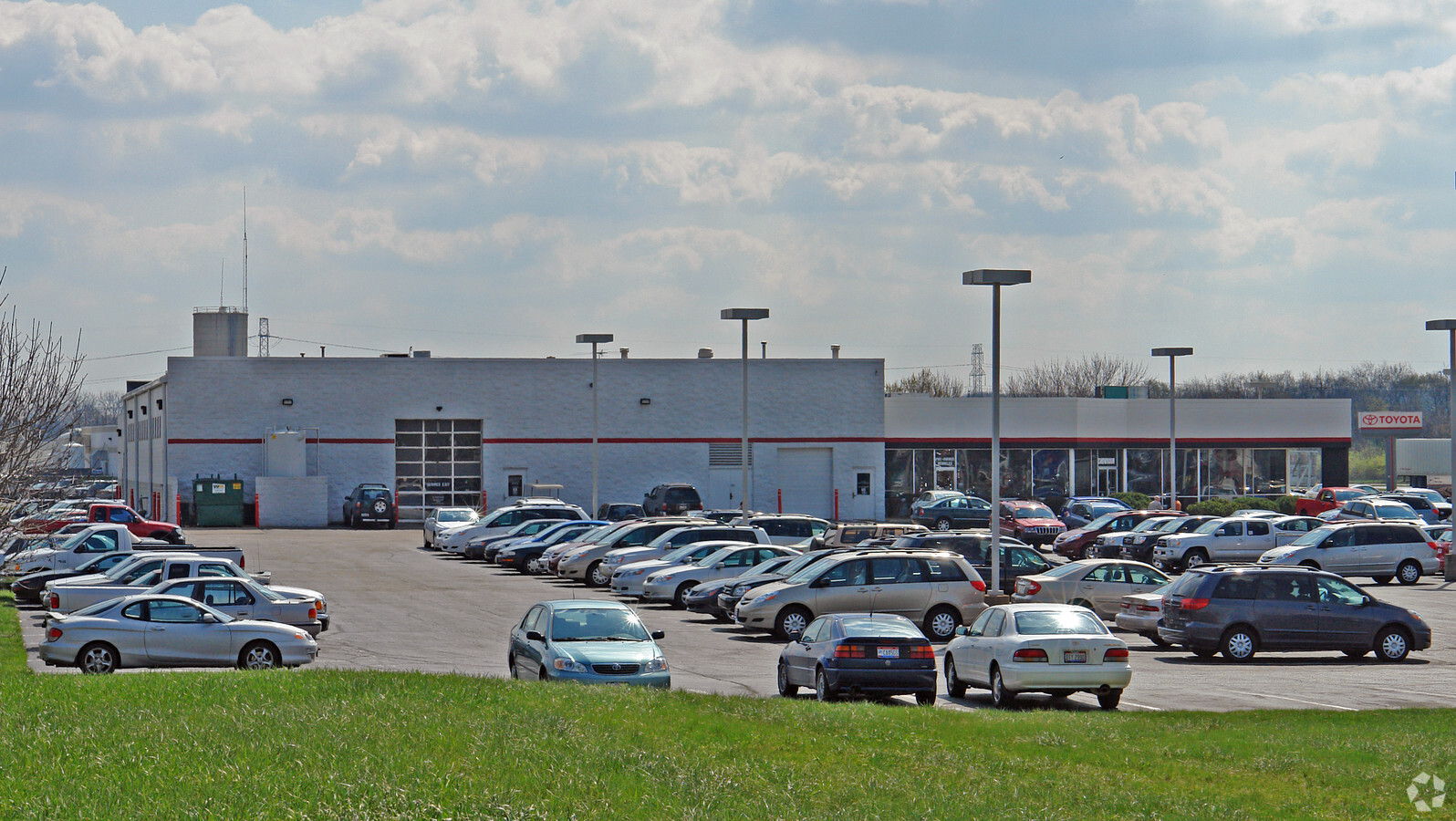
Property Record
2110 Heller Dr, Beavercreek, OH 45434

NEARBY LISTINGS FOR SALE OR LEASE
Property Detail
2110 Heller Dr
Dayton, OH
Beavercreek Bus Center
B03-0002-0033-0-0029-00
BEAVERCREEK BUS CENTER LOT 5-B REPLAT 5.401AC HELLER DR
Vehiclerentalsvehiclesales
Greene
X
Ohio
39057C0109E
5
2024
5.40 AC
2023
East Dayton
210603
Cincinnati/Dayton
21,588 SF
DEMOGRAPHICS near 2110 Heller Dr
1 Mile
3 Mile
5 Mile
2024 Total Population
623
20,710
80,454
2029 Population
636
21,093
82,217
Pop Growth 2024-2029
+ 2.09%
+ 1.85%
+ 2.19%
Average Age
41
43
42
2024 Total Households
220
7,556
31,929
HH Growth 2024-2029
+ 2.27%
+ 1.80%
+ 2.14%
Median Household Inc
$142,045
$131,575
$92,243
Avg Household Size
2.80
2.70
2.40
2024 Avg HH Vehicles
3.00
2.00
2.00
Median Home Value
$342,029
$303,177
$235,240
Median Year Built
1996
1980
1977
Nearby Places
- Restaurants
- Banks
- Shops
- Fitness
- Groceries
PUBLIC TRANSPORTATION
AIRPORT
James M Cox Dayton International
DRIVE
WALK
Distance
James M Cox Dayton International
37 min
23.0 mi
Freight Ports
Port of Toledo
DRIVE
WALK
Distance
Port of Toledo
194 min
163.1 mi
Nearby Properties
Address
Land Use
TOTAL SIZE
Lot Size
Zoning
Address
Land Use
TOTAL SIZE
Lot Size
Zoning
286,260 SF
47.65 AC
Address
Land Use
TOTAL SIZE
Lot Size
Zoning
145,500 SF
32.62 AC
A1
Address
Land Use
TOTAL SIZE
Lot Size
Zoning
108,274 SF
25.08 AC
RPUD427
Address
Land Use
TOTAL SIZE
Lot Size
Zoning
7,694 SF
20.52 AC
MULTIPLE
Address
Land Use
TOTAL SIZE
Lot Size
Zoning
134,260 SF
11.75 AC
Address
Land Use
TOTAL SIZE
Lot Size
Zoning
217,579 SF
22.16 AC
Address
Land Use
TOTAL SIZE
Lot Size
Zoning
320 SF
65.47 AC
Address
Land Use
TOTAL SIZE
Lot Size
Zoning
26.91 AC
Address
Land Use
TOTAL SIZE
Lot Size
Zoning
2,400 SF
37.61 AC
Address
Land Use
TOTAL SIZE
Lot Size
Zoning
136,915 SF
16.23 AC
Address
Land Use
TOTAL SIZE
Lot Size
Zoning
78,330 SF
35.06 AC
Address
Land Use
TOTAL SIZE
Lot Size
Zoning
3.54 AC
MULTIPLE
Address
Land Use
TOTAL SIZE
Lot Size
Zoning
41,778 SF
6.82 AC
Address
Land Use
TOTAL SIZE
Lot Size
Zoning
77,673 SF
16.02 AC
A1
Address
Land Use
TOTAL SIZE
Lot Size
Zoning
1,012 SF
464.56 AC
Address
Land Use
TOTAL SIZE
Lot Size
Zoning
40,682 SF
11 AC
A1
Address
Land Use
TOTAL SIZE
Lot Size
Zoning
30,056 SF
8.18 AC
Address
Land Use
TOTAL SIZE
Lot Size
Zoning
33,300 SF
20.35 AC
Address
Land Use
TOTAL SIZE
Lot Size
Zoning
7,000 SF
5.42 AC
Address
Land Use
TOTAL SIZE
Lot Size
Zoning
27,059 SF
8.99 AC
Address
Land Use
TOTAL SIZE
Lot Size
Zoning
48,471 SF
15.66 AC
A1
Address
Land Use
TOTAL SIZE
Lot Size
Zoning
110,592 SF
7.22 AC
Address
Land Use
TOTAL SIZE
Lot Size
Zoning
49,686 SF
10 AC
MULTIPLE
Address
Land Use
TOTAL SIZE
Lot Size
Zoning
3,248 SF
173.15 AC
Address
Land Use
TOTAL SIZE
Lot Size
Zoning
26,942 SF
4.77 AC
Address
Land Use
TOTAL SIZE
Lot Size
Zoning
26,958 SF
2.98 AC
CPUD891
Address
Land Use
TOTAL SIZE
Lot Size
Zoning
94,000 SF
7.64 AC
Address
Land Use
TOTAL SIZE
Lot Size
Zoning
24,940 SF
16 AC
Address
Land Use
TOTAL SIZE
Lot Size
Zoning
3,200 SF
167.63 AC
Address
Land Use
TOTAL SIZE
Lot Size
Zoning
1,408 SF
73.06 AC
The World's #1 Commercial Real Estate Marketplace
Connect with us
© 2025 CoStar Group
The information above has been obtained from sources believed reliable. While we do not doubt its accuracy we have not verified it and make no guarantee, warranty or representation about it. It is your responsibility to independently confirm its accuracy and completeness. Any projections, opinions, assumptions, or estimates used are for example only and do not represent the current or future performance of the property. The value of this transaction to you depends on tax and other factors which should be evaluated by your tax, financial, and legal advisors. You and your advisors should conduct a careful, independent investigation of the property to determine to your satisfaction the suitability of the property for your needs.