Property Record
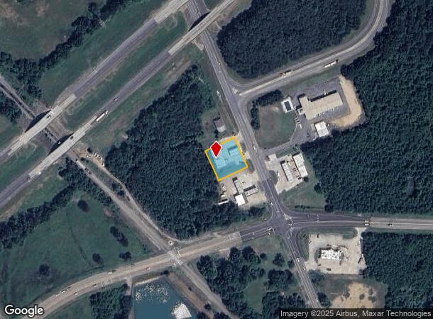
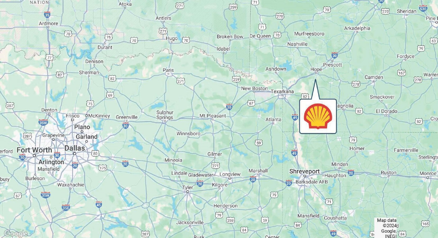
2112 N Hazel St, Hope, AR 71801
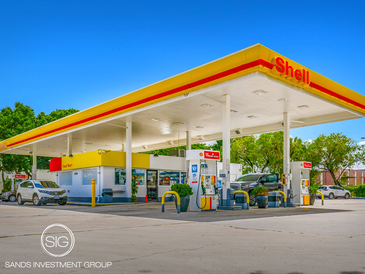
This Property Is For Sale
NEARBY LISTINGS FOR SALE OR LEASE
-
-
-
No Photo
-
View all Hope listings for sale on LoopNet.com
Property Detail
2112 N Hazel St
700-04777-001-C
Hope City Metes & Bounds
Conveniencestore
PT NW SW S OF I30
X
Hempstead
05057C0355C
Arkansas
2023
0.59 AC
2024
Arkansas South Area
480301
Other Market Areas
2,905 SF
Hope, AR
DEMOGRAPHICS near 2112 N Hazel St
1 Mile
3 Mile
5 Mile
2024 Total Population
952
9,137
11,191
2029 Population
984
8,847
10,789
Pop Growth 2024-2029
+ 3.36%
(3.17%)
(3.59%)
Average Age
42
38
39
2024 Total Households
409
3,561
4,410
HH Growth 2024-2029
+ 3.42%
(2.95%)
(3.40%)
Median Household Inc
$32,096
$42,275
$42,768
Avg Household Size
2.30
2.40
2.40
2024 Avg HH Vehicles
1.00
2.00
2.00
Median Home Value
$56,221
$81,798
$90,951
Median Year Built
1978
1974
1974
Nearby Places
- Restaurants
- Banks
- Shops
- Fitness
- Groceries
PUBLIC TRANSPORTATION
COMMUTER RAIL
Hope Amtrak Station (Texas Eagle - Amtrak)
DRIVE
WALK
Distance
Hope Amtrak Station (Texas Eagle - Amtrak)
3 min
1.6 mi
AIRPORT
Texarkana Regional-Webb Field
DRIVE
WALK
Distance
Texarkana Regional-Webb Field
40 min
33.3 mi
Freight Ports
Port of Shreveport
DRIVE
WALK
Distance
Port of Shreveport
137 min
124.5 mi
Nearby Properties
Address
Land Use
TOTAL SIZE
Lot Size
Zoning
Address
Land Use
TOTAL SIZE
Lot Size
Zoning
34,809 SF
2.01 AC
Address
Land Use
TOTAL SIZE
Lot Size
Zoning
158,999 SF
17.80 AC
Address
Land Use
TOTAL SIZE
Lot Size
Zoning
89,999 SF
15.61 AC
Address
Land Use
TOTAL SIZE
Lot Size
Zoning
32,972 SF
1.30 AC
Address
Land Use
TOTAL SIZE
Lot Size
Zoning
42,921 SF
3.87 AC
Address
Land Use
TOTAL SIZE
Lot Size
Zoning
48,716 SF
2.53 AC
Address
Land Use
TOTAL SIZE
Lot Size
Zoning
80,174 SF
7.45 AC
Address
Land Use
TOTAL SIZE
Lot Size
Zoning
171,704 SF
8.40 AC
Address
Land Use
TOTAL SIZE
Lot Size
Zoning
46,848 SF
10.22 AC
Address
Land Use
TOTAL SIZE
Lot Size
Zoning
89,632 SF
6.39 AC
Address
Land Use
TOTAL SIZE
Lot Size
Zoning
42,021 SF
5 AC
Address
Land Use
TOTAL SIZE
Lot Size
Zoning
49,785 SF
3.83 AC
Address
Land Use
TOTAL SIZE
Lot Size
Zoning
28,884 SF
3.27 AC
Address
Land Use
TOTAL SIZE
Lot Size
Zoning
31,418 SF
0.98 AC
Address
Land Use
TOTAL SIZE
Lot Size
Zoning
33,143 SF
6.57 AC
Address
Land Use
TOTAL SIZE
Lot Size
Zoning
8,622 SF
1.95 AC
Address
Land Use
TOTAL SIZE
Lot Size
Zoning
14,406 SF
1.76 AC
Address
Land Use
TOTAL SIZE
Lot Size
Zoning
26,936 SF
3.24 AC
Address
Land Use
TOTAL SIZE
Lot Size
Zoning
8,459 SF
0.39 AC
Address
Land Use
TOTAL SIZE
Lot Size
Zoning
28,398 SF
2.07 AC
Address
Land Use
TOTAL SIZE
Lot Size
Zoning
285,790 SF
4.26 AC
Address
Land Use
TOTAL SIZE
Lot Size
Zoning
9,264 SF
7.58 AC
Address
Land Use
TOTAL SIZE
Lot Size
Zoning
144,690 SF
21.44 AC
Address
Land Use
TOTAL SIZE
Lot Size
Zoning
28,835 SF
1.96 AC
Address
Land Use
TOTAL SIZE
Lot Size
Zoning
33,442 SF
6.20 AC
Address
Land Use
TOTAL SIZE
Lot Size
Zoning
2,894 SF
0.41 AC
Address
Land Use
TOTAL SIZE
Lot Size
Zoning
25,336 SF
6.88 AC
Address
Land Use
TOTAL SIZE
Lot Size
Zoning
5,072 SF
1.52 AC
Address
Land Use
TOTAL SIZE
Lot Size
Zoning
25,611 SF
2.01 AC
Address
Land Use
TOTAL SIZE
Lot Size
Zoning
72,215 SF
9.18 AC
The World's #1 Commercial Real Estate Marketplace
Connect with us
© 2025 CoStar Group
The information above has been obtained from sources believed reliable. While we do not doubt its accuracy we have not verified it and make no guarantee, warranty or representation about it. It is your responsibility to independently confirm its accuracy and completeness. Any projections, opinions, assumptions, or estimates used are for example only and do not represent the current or future performance of the property. The value of this transaction to you depends on tax and other factors which should be evaluated by your tax, financial, and legal advisors. You and your advisors should conduct a careful, independent investigation of the property to determine to your satisfaction the suitability of the property for your needs.