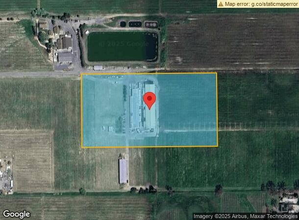
Property Record
2120 Olivet Rd, Santa Rosa, CA 95401
NEARBY LISTINGS FOR SALE OR LEASE
Property Detail
2120 Olivet Rd
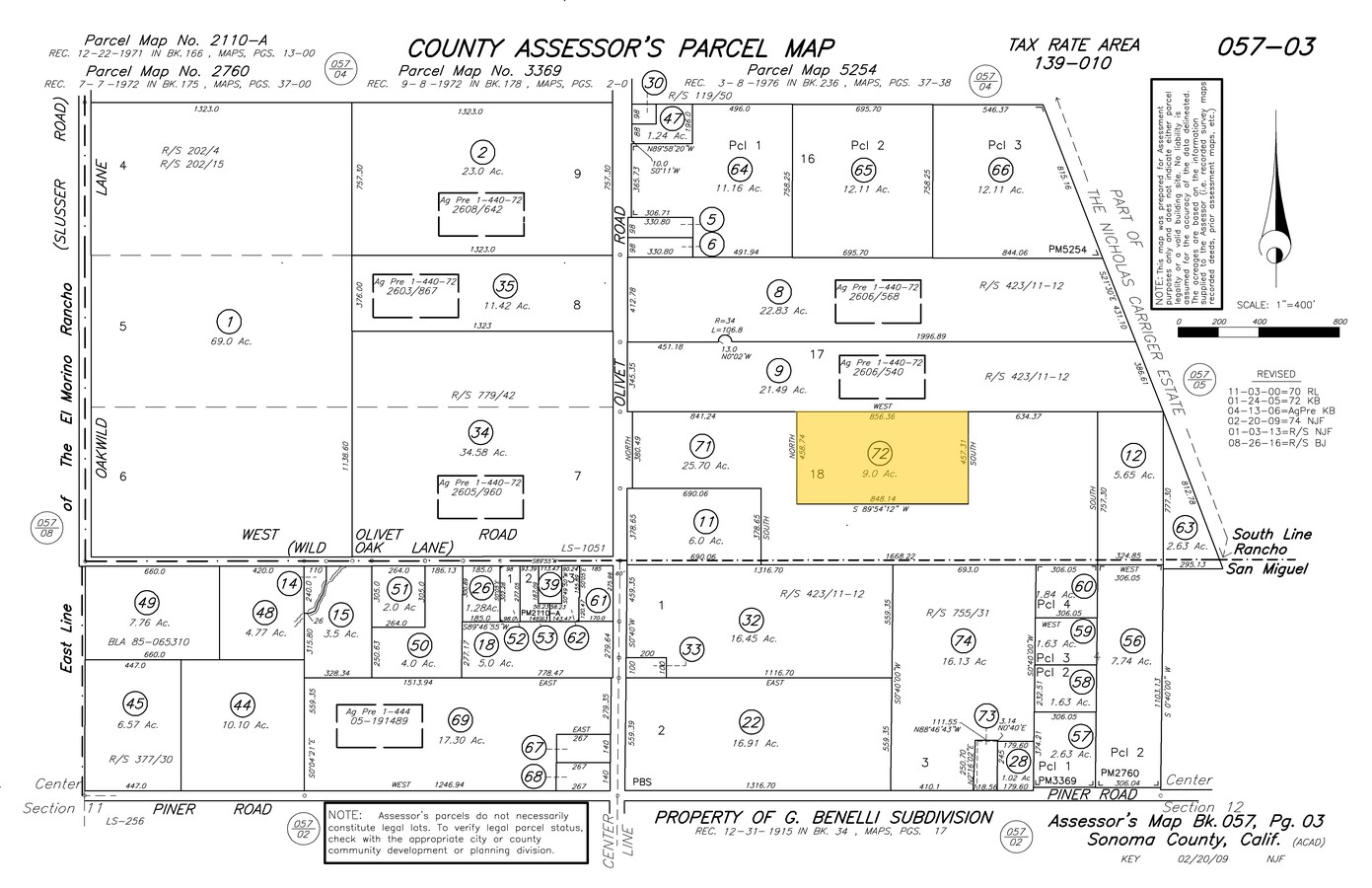
057-030-072
Sweetwater Land & Cattle Company
Winery
2005 FM PTN 057-030-070 LLA 03-0050
X
Sonoma
06097C0706F
California
2023
9 AC
2023
Santa Rosa
1529061012
North Bay/Santa Rosa
21,971 SF
Santa Rosa, CA
DEMOGRAPHICS near 2120 Olivet Rd
1 Mile
3 Mile
5 Mile
2024 Total Population
522
14,994
103,135
2029 Population
492
14,613
101,819
Pop Growth 2024-2029
(5.75%)
(2.54%)
(1.28%)
Average Age
45
42
41
2024 Total Households
191
5,467
37,442
HH Growth 2024-2029
(5.76%)
(2.69%)
(1.28%)
Median Household Inc
$136,607
$123,460
$98,461
Avg Household Size
2.60
2.70
2.60
2024 Avg HH Vehicles
3.00
2.00
2.00
Median Home Value
$901,234
$757,085
$712,674
Median Year Built
1974
1983
1982
Nearby Places
- Restaurants
- Banks
- Shops
- Fitness
- Groceries
PUBLIC TRANSPORTATION
COMMUTER RAIL
Sonoma County Airport Smart (Main Line - Sonoma Marin Area Rail Transit)
DRIVE
WALK
Distance
Sonoma County Airport Smart (Main Line - Sonoma Marin Area Rail Transit)
14 min
6.2 mi
Santa Rosa North Smart (Main Line - Sonoma Marin Area Rail Transit)
DRIVE
WALK
Distance
Santa Rosa North Smart (Main Line - Sonoma Marin Area Rail Transit)
14 min
6.2 mi
AIRPORT
Charles M Schulz - Sonoma County
DRIVE
WALK
Distance
Charles M Schulz - Sonoma County
15 min
5.2 mi
Freight Ports
Port of Richmond
DRIVE
WALK
Distance
Port of Richmond
77 min
57.7 mi
Nearby Properties
Address
Land Use
TOTAL SIZE
Lot Size
Zoning
Address
Land Use
TOTAL SIZE
Lot Size
Zoning
46,737 SF
80 AC
DA60
Address
Land Use
TOTAL SIZE
Lot Size
Zoning
71,800 SF
7.76 AC
CIPD
Address
Land Use
TOTAL SIZE
Lot Size
Zoning
163,194 SF
15.09 AC
Address
Land Use
TOTAL SIZE
Lot Size
Zoning
70,358 SF
4.51 AC
M1
Address
Land Use
TOTAL SIZE
Lot Size
Zoning
146,448 SF
84.59 AC
Address
Land Use
TOTAL SIZE
Lot Size
Zoning
69,962 SF
4.49 AC
Address
Land Use
TOTAL SIZE
Lot Size
Zoning
63,890 SF
3.72 AC
Address
Land Use
TOTAL SIZE
Lot Size
Zoning
63,890 SF
4.05 AC
Address
Land Use
TOTAL SIZE
Lot Size
Zoning
71,564 SF
5.74 AC
CITYSR
Address
Land Use
TOTAL SIZE
Lot Size
Zoning
14,962 SF
20.02 AC
Address
Land Use
TOTAL SIZE
Lot Size
Zoning
64,235 SF
5.61 AC
CITYSR
Address
Land Use
TOTAL SIZE
Lot Size
Zoning
59,504 SF
3.41 AC
Address
Land Use
TOTAL SIZE
Lot Size
Zoning
53,599 SF
3.51 AC
Address
Land Use
TOTAL SIZE
Lot Size
Zoning
74,665 SF
4.90 AC
M1
Address
Land Use
TOTAL SIZE
Lot Size
Zoning
48,100 SF
2.75 AC
Address
Land Use
TOTAL SIZE
Lot Size
Zoning
22,493 SF
40.24 AC
Address
Land Use
TOTAL SIZE
Lot Size
Zoning
29,597 SF
96.67 AC
Address
Land Use
TOTAL SIZE
Lot Size
Zoning
48,100 SF
2.79 AC
Address
Land Use
TOTAL SIZE
Lot Size
Zoning
40,900 SF
1.90 AC
Address
Land Use
TOTAL SIZE
Lot Size
Zoning
2,029 SF
121.99 AC
Address
Land Use
TOTAL SIZE
Lot Size
Zoning
50,552 SF
2.87 AC
CITYSR
Address
Land Use
TOTAL SIZE
Lot Size
Zoning
28,466 SF
1.91 AC
Address
Land Use
TOTAL SIZE
Lot Size
Zoning
28,466 SF
1.85 AC
Address
Land Use
TOTAL SIZE
Lot Size
Zoning
42,878 SF
7.55 AC
M240000F
Address
Land Use
TOTAL SIZE
Lot Size
Zoning
13,800 SF
12.17 AC
LIA40
Address
Land Use
TOTAL SIZE
Lot Size
Zoning
70,281 SF
4.47 AC
Address
Land Use
TOTAL SIZE
Lot Size
Zoning
9,127 SF
262.94 AC
LEAB7FRZN
Address
Land Use
TOTAL SIZE
Lot Size
Zoning
108.93 AC
LIA40
Address
Land Use
TOTAL SIZE
Lot Size
Zoning
66,548 SF
3.14 AC
M1
Address
Land Use
TOTAL SIZE
Lot Size
Zoning
65,547 SF
5.21 AC
The World's #1 Commercial Real Estate Marketplace
Connect with us
© 2025 CoStar Group
The information above has been obtained from sources believed reliable. While we do not doubt its accuracy we have not verified it and make no guarantee, warranty or representation about it. It is your responsibility to independently confirm its accuracy and completeness. Any projections, opinions, assumptions, or estimates used are for example only and do not represent the current or future performance of the property. The value of this transaction to you depends on tax and other factors which should be evaluated by your tax, financial, and legal advisors. You and your advisors should conduct a careful, independent investigation of the property to determine to your satisfaction the suitability of the property for your needs.