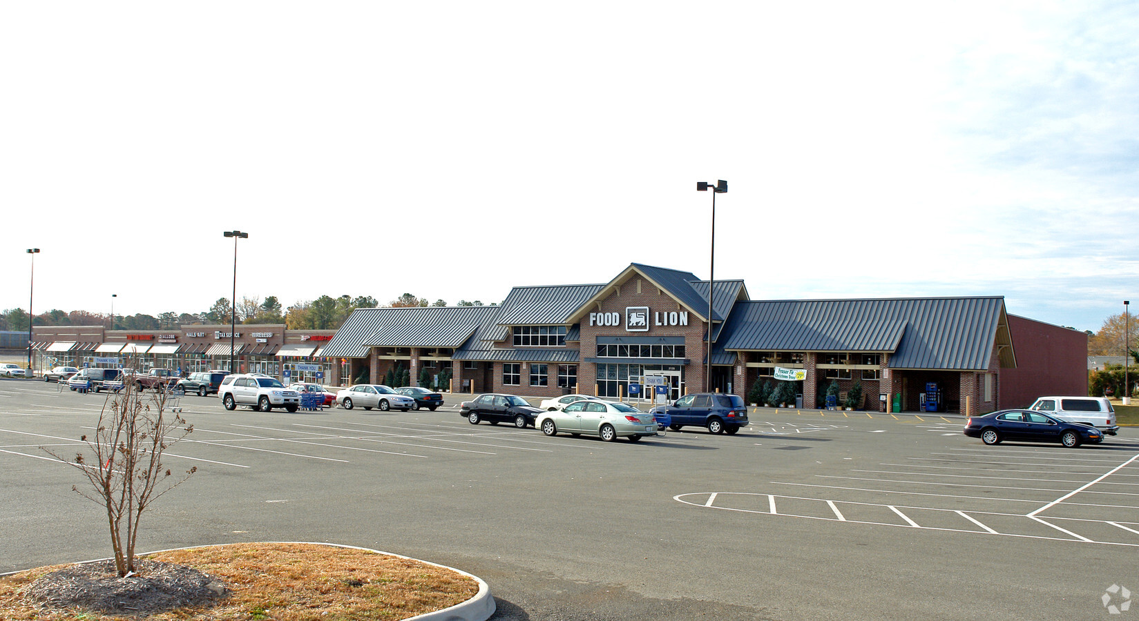
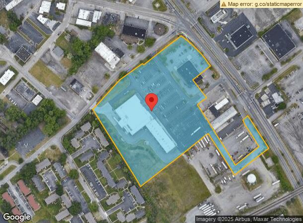
Property Record
2120 S Crater Rd, Petersburg, VA 23805
NEARBY LISTINGS FOR SALE OR LEASE
Property Detail
2120 S Crater Rd
066-05-0006
PARCEL 2 4.492 ACRES
Stripcommercialcenter
Petersburg
X
Virginia
51041C0435E
4.49 AC
2023
Petersburg
2024
Richmond VA
811000
Richmond, VA
44,779 SF
DEMOGRAPHICS near 2120 S Crater Rd
1 Mile
3 Mile
5 Mile
2024 Total Population
6,617
31,504
73,687
2029 Population
6,415
31,254
74,653
Pop Growth 2024-2029
(3.05%)
(0.79%)
+ 1.31%
Average Age
43
41
38
2024 Total Households
2,806
14,457
27,360
HH Growth 2024-2029
(3.14%)
(0.77%)
+ 1.07%
Median Household Inc
$61,525
$45,685
$52,972
Avg Household Size
2.20
2.10
2.30
2024 Avg HH Vehicles
2.00
1.00
2.00
Median Home Value
$154,951
$145,151
$165,278
Median Year Built
1964
1970
1972
Nearby Places
- Restaurants
- Banks
- Shops
- Fitness
- Groceries
PUBLIC TRANSPORTATION
COMMUTER RAIL
Petersburg Amtrak Station (Carolinian - Amtrak, Northeast Regional - Amtrak, Palmetto - Amtrak, Silver Meteor - Amtrak, Silver Star - Amtrak)
DRIVE
WALK
Distance
Petersburg Amtrak Station (Carolinian - Amtrak, Northeast Regional - Amtrak, Palmetto - Amtrak, Silver Meteor - Amtrak, Silver Star - Amtrak)
9 min
4.7 mi
AIRPORT
Richmond International
DRIVE
WALK
Distance
Richmond International
40 min
29.9 mi
Freight Ports
Virginia Port Authority - Richmond
DRIVE
WALK
Distance
Virginia Port Authority - Richmond
31 min
21.3 mi
Nearby Properties
Address
Land Use
TOTAL SIZE
Lot Size
Zoning
Address
Land Use
TOTAL SIZE
Lot Size
Zoning
24.02 AC
B-2C
Address
Land Use
TOTAL SIZE
Lot Size
Zoning
28.17 AC
PUD
Address
Land Use
TOTAL SIZE
Lot Size
Zoning
32.59 AC
R-4
Address
Land Use
TOTAL SIZE
Lot Size
Zoning
17.09 AC
PUD
Address
Land Use
TOTAL SIZE
Lot Size
Zoning
11.56 AC
PUD
Address
Land Use
TOTAL SIZE
Lot Size
Zoning
3.10 AC
M-1
Address
Land Use
TOTAL SIZE
Lot Size
Zoning
205,626 SF
152.69 AC
M-2
Address
Land Use
TOTAL SIZE
Lot Size
Zoning
407,650 SF
136.67 AC
M-2
Address
Land Use
TOTAL SIZE
Lot Size
Zoning
14.57 AC
R-4
Address
Land Use
TOTAL SIZE
Lot Size
Zoning
89,734 SF
2.85 AC
B1
Address
Land Use
TOTAL SIZE
Lot Size
Zoning
185,483 SF
20.98 AC
R-4
Address
Land Use
TOTAL SIZE
Lot Size
Zoning
8.46 AC
R-4
Address
Land Use
TOTAL SIZE
Lot Size
Zoning
3,632 SF
11.30 AC
M-2
Address
Land Use
TOTAL SIZE
Lot Size
Zoning
68,438 SF
1.93 AC
Address
Land Use
TOTAL SIZE
Lot Size
Zoning
42,561 SF
6.91 AC
B-2C
Address
Land Use
TOTAL SIZE
Lot Size
Zoning
151,980 SF
23.12 AC
PUD
Address
Land Use
TOTAL SIZE
Lot Size
Zoning
14.68 AC
R-4
Address
Land Use
TOTAL SIZE
Lot Size
Zoning
182,760 SF
10.50 AC
R-4
Address
Land Use
TOTAL SIZE
Lot Size
Zoning
1.09 AC
PUD
Address
Land Use
TOTAL SIZE
Lot Size
Zoning
8.72 AC
PUD
Address
Land Use
TOTAL SIZE
Lot Size
Zoning
498.93 AC
Address
Land Use
TOTAL SIZE
Lot Size
Zoning
46,802 SF
14.50 AC
R-2
Address
Land Use
TOTAL SIZE
Lot Size
Zoning
99,997 SF
6.95 AC
R4
Address
Land Use
TOTAL SIZE
Lot Size
Zoning
102,424 SF
14.71 AC
PUD
Address
Land Use
TOTAL SIZE
Lot Size
Zoning
51,420 SF
1.83 AC
PUD
Address
Land Use
TOTAL SIZE
Lot Size
Zoning
84,064 SF
15.54 AC
PUD
Address
Land Use
TOTAL SIZE
Lot Size
Zoning
67,882 SF
1.55 AC
PUD
Address
Land Use
TOTAL SIZE
Lot Size
Zoning
149,228 SF
25.06 AC
M-2
Address
Land Use
TOTAL SIZE
Lot Size
Zoning
33,360 SF
0.45 AC
B-2C
Address
Land Use
TOTAL SIZE
Lot Size
Zoning
101,722 SF
33.23 AC
M-2
The World's #1 Commercial Real Estate Marketplace
Connect with us
© 2025 CoStar Group
The information above has been obtained from sources believed reliable. While we do not doubt its accuracy we have not verified it and make no guarantee, warranty or representation about it. It is your responsibility to independently confirm its accuracy and completeness. Any projections, opinions, assumptions, or estimates used are for example only and do not represent the current or future performance of the property. The value of this transaction to you depends on tax and other factors which should be evaluated by your tax, financial, and legal advisors. You and your advisors should conduct a careful, independent investigation of the property to determine to your satisfaction the suitability of the property for your needs.