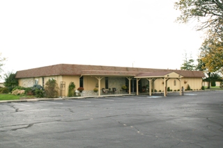
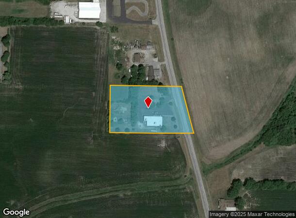
Property Record
2120 S State Road 39, Frankfort, IN 46041
NEARBY LISTINGS FOR SALE OR LEASE
Property Detail
2120 S State Road 39
Officebuilding
003-28007-00 PT PT S NW NE 22-21-1W 3.0648A 1010-630-B2-A
X
Clinton
18023C0144C
Indiana
2023
3.06 AC
2023
Other Market Areas
950400
Frankfort, IN
6,540 SF
12-10-22-201-024.000-004
DEMOGRAPHICS near 2120 S State Road 39
1 Mile
3 Mile
5 Mile
2024 Total Population
750
18,356
20,063
2029 Population
743
18,334
20,007
Pop Growth 2024-2029
(0.93%)
(0.12%)
(0.28%)
Average Age
41
37
38
2024 Total Households
288
6,713
7,377
HH Growth 2024-2029
(1.04%)
(0.10%)
(0.27%)
Median Household Inc
$52,692
$48,831
$50,128
Avg Household Size
2.60
2.60
2.60
2024 Avg HH Vehicles
2.00
2.00
2.00
Median Home Value
$150,819
$111,586
$119,937
Median Year Built
1954
1954
1955
Nearby Places
- Restaurants
- Banks
- Shops
- Fitness
- Groceries
Nearby Properties
Address
Land Use
TOTAL SIZE
Lot Size
Zoning
Address
Land Use
TOTAL SIZE
Lot Size
Zoning
341,254 SF
33 AC
Address
Land Use
TOTAL SIZE
Lot Size
Zoning
154,470 SF
17.20 AC
Address
Land Use
TOTAL SIZE
Lot Size
Zoning
50,034 SF
6.80 AC
Address
Land Use
TOTAL SIZE
Lot Size
Zoning
271,340 SF
16.50 AC
5
Address
Land Use
TOTAL SIZE
Lot Size
Zoning
33,296 SF
10 AC
Address
Land Use
TOTAL SIZE
Lot Size
Zoning
2,704 SF
24.25 AC
Address
Land Use
TOTAL SIZE
Lot Size
Zoning
149,092 SF
12.06 AC
Address
Land Use
TOTAL SIZE
Lot Size
Zoning
63,800 SF
10.23 AC
Address
Land Use
TOTAL SIZE
Lot Size
Zoning
299,752 SF
29.77 AC
Address
Land Use
TOTAL SIZE
Lot Size
Zoning
21,350 SF
6.08 AC
Address
Land Use
TOTAL SIZE
Lot Size
Zoning
15,552 SF
19.02 AC
Address
Land Use
TOTAL SIZE
Lot Size
Zoning
25,624 SF
4 AC
Address
Land Use
TOTAL SIZE
Lot Size
Zoning
137,150 SF
24.28 AC
Address
Land Use
TOTAL SIZE
Lot Size
Zoning
93,138 SF
3.69 AC
Address
Land Use
TOTAL SIZE
Lot Size
Zoning
36,349 SF
4.34 AC
Address
Land Use
TOTAL SIZE
Lot Size
Zoning
1,250 SF
6.73 AC
Address
Land Use
TOTAL SIZE
Lot Size
Zoning
11,086 SF
2.62 AC
Address
Land Use
TOTAL SIZE
Lot Size
Zoning
73,861 SF
10.57 AC
Address
Land Use
TOTAL SIZE
Lot Size
Zoning
16,984 SF
5.69 AC
Address
Land Use
TOTAL SIZE
Lot Size
Zoning
53,404 SF
9.49 AC
Address
Land Use
TOTAL SIZE
Lot Size
Zoning
17,940 SF
8.27 AC
Address
Land Use
TOTAL SIZE
Lot Size
Zoning
19,970 SF
2.84 AC
Address
Land Use
TOTAL SIZE
Lot Size
Zoning
13,410 SF
7.24 AC
Address
Land Use
TOTAL SIZE
Lot Size
Zoning
1,672 SF
4.99 AC
Address
Land Use
TOTAL SIZE
Lot Size
Zoning
20,804 SF
1.08 AC
Address
Land Use
TOTAL SIZE
Lot Size
Zoning
71,026 SF
14.97 AC
Address
Land Use
TOTAL SIZE
Lot Size
Zoning
19,649 SF
0.39 AC
Address
Land Use
TOTAL SIZE
Lot Size
Zoning
25,842 SF
0.57 AC
Address
Land Use
TOTAL SIZE
Lot Size
Zoning
15,234 SF
2.42 AC
Address
Land Use
TOTAL SIZE
Lot Size
Zoning
2,048 SF
4.15 AC
The World's #1 Commercial Real Estate Marketplace
Connect with us
© 2025 CoStar Group
The information above has been obtained from sources believed reliable. While we do not doubt its accuracy we have not verified it and make no guarantee, warranty or representation about it. It is your responsibility to independently confirm its accuracy and completeness. Any projections, opinions, assumptions, or estimates used are for example only and do not represent the current or future performance of the property. The value of this transaction to you depends on tax and other factors which should be evaluated by your tax, financial, and legal advisors. You and your advisors should conduct a careful, independent investigation of the property to determine to your satisfaction the suitability of the property for your needs.