Property Record
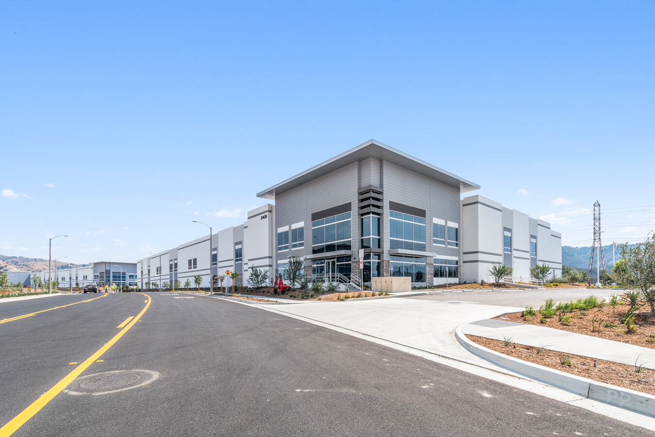
21420 Needham Ranch Pkwy, Newhall, CA 91321
NEARBY LISTINGS FOR SALE OR LEASE
-
-
View all Newhall listings for lease on LoopNet.com
Property Detail
21420 Needham Ranch Pkwy
2827-053-022
TR=50283-02 EX OF ST LOT 4
Warehouse
Los Angeles
AE
California
06037C0819G
4
2024
4.21 AC
2024
Santa Clarita Valley
920312
Los Angeles
97,613 SF
Los Angeles-Long Beach-Glendale, CA
DEMOGRAPHICS near 21420 Needham Ranch Pkwy
1 Mile
3 Mile
5 Mile
2024 Total Population
3,465
32,001
139,055
2029 Population
3,364
30,872
134,272
Pop Growth 2024-2029
(2.91%)
(3.53%)
(3.44%)
Average Age
35
38
40
2024 Total Households
994
9,940
45,932
HH Growth 2024-2029
(3.02%)
(3.89%)
(3.63%)
Median Household Inc
$49,883
$90,922
$98,931
Avg Household Size
3.20
3.10
2.90
2024 Avg HH Vehicles
2.00
2.00
2.00
Median Home Value
$397,726
$742,533
$708,403
Median Year Built
1981
1978
1983
Nearby Places
- Restaurants
- Banks
- Shops
- Fitness
- Groceries
PUBLIC TRANSPORTATION
COMMUTER RAIL
Newhall (Antelope Valley Line - Southern California Regional Rail Authority (Metrolink))
DRIVE
WALK
Distance
Newhall (Antelope Valley Line - Southern California Regional Rail Authority (Metrolink))
7 min
2.9 mi
Santa Clarita (Antelope Valley Line - Southern California Regional Rail Authority (Metrolink))
DRIVE
WALK
Distance
Santa Clarita (Antelope Valley Line - Southern California Regional Rail Authority (Metrolink))
14 min
7.2 mi
AIRPORT
Bob Hope
DRIVE
WALK
Distance
Bob Hope
23 min
16.9 mi
Los Angeles International
DRIVE
WALK
Distance
Los Angeles International
45 min
34.0 mi
Freight Ports
The Port of Hueneme
DRIVE
WALK
Distance
The Port of Hueneme
76 min
52.4 mi
SALE & LEASE HISTORY
LISTING DATE
SALE/LEASE

Jan 29, 2019
For Lease
Nearby Properties
Address
Land Use
TOTAL SIZE
Lot Size
Zoning
Address
Land Use
TOTAL SIZE
Lot Size
Zoning
143,163 SF
10.48 AC
SCUR3
Address
Land Use
TOTAL SIZE
Lot Size
Zoning
219,340 SF
12.77 AC
LAR3
Address
Land Use
TOTAL SIZE
Lot Size
Zoning
137,361 SF
7.38 AC
SCUR3
Address
Land Use
TOTAL SIZE
Lot Size
Zoning
220,738 SF
10.27 AC
LAM1
Address
Land Use
TOTAL SIZE
Lot Size
Zoning
144,152 SF
2.39 AC
LCA22-A21*
Address
Land Use
TOTAL SIZE
Lot Size
Zoning
52,194 SF
0.76 AC
SCCP
Address
Land Use
TOTAL SIZE
Lot Size
Zoning
180,584 SF
6.35 AC
SCUR3
Address
Land Use
TOTAL SIZE
Lot Size
Zoning
209,119 SF
3.24 AC
SCBP
Address
Land Use
TOTAL SIZE
Lot Size
Zoning
169,585 SF
9.16 AC
SCBP
Address
Land Use
TOTAL SIZE
Lot Size
Zoning
187,990 SF
9.18 AC
SCBP
Address
Land Use
TOTAL SIZE
Lot Size
Zoning
51,597 SF
2.13 AC
SCCP
Address
Land Use
TOTAL SIZE
Lot Size
Zoning
75,251 SF
1.71 AC
SCUR3
Address
Land Use
TOTAL SIZE
Lot Size
Zoning
57,232 SF
0.27 AC
SCSP
Address
Land Use
TOTAL SIZE
Lot Size
Zoning
135,228 SF
7.80 AC
SCUR3
Address
Land Use
TOTAL SIZE
Lot Size
Zoning
42,767 SF
0.26 AC
SCSP
Address
Land Use
TOTAL SIZE
Lot Size
Zoning
33,578 SF
SCCP
Address
Land Use
TOTAL SIZE
Lot Size
Zoning
188,057 SF
2.70 AC
SCCP
Address
Land Use
TOTAL SIZE
Lot Size
Zoning
92,596 SF
4.59 AC
LAM1
Address
Land Use
TOTAL SIZE
Lot Size
Zoning
48,867 SF
1.26 AC
SCUR2
Address
Land Use
TOTAL SIZE
Lot Size
Zoning
68,670 SF
3.22 AC
LAM1
Address
Land Use
TOTAL SIZE
Lot Size
Zoning
110,126 SF
6.31 AC
SCBP
Address
Land Use
TOTAL SIZE
Lot Size
Zoning
125,282 SF
8.17 AC
SCPI
Address
Land Use
TOTAL SIZE
Lot Size
Zoning
41,192 SF
3.01 AC
SCSP
Address
Land Use
TOTAL SIZE
Lot Size
Zoning
40,000 SF
3.61 AC
SCCP
Address
Land Use
TOTAL SIZE
Lot Size
Zoning
83,136 SF
4.73 AC
SCUR3
Address
Land Use
TOTAL SIZE
Lot Size
Zoning
37,606 SF
3.55 AC
LAM1
Address
Land Use
TOTAL SIZE
Lot Size
Zoning
24,663 SF
1.79 AC
SCMX-C
Address
Land Use
TOTAL SIZE
Lot Size
Zoning
74,112 SF
23.12 AC
SCUR3
Address
Land Use
TOTAL SIZE
Lot Size
Zoning
66,961 SF
4.49 AC
SCBP
The World's #1 Commercial Real Estate Marketplace
Connect with us
© 2025 CoStar Group
The information above has been obtained from sources believed reliable. While we do not doubt its accuracy we have not verified it and make no guarantee, warranty or representation about it. It is your responsibility to independently confirm its accuracy and completeness. Any projections, opinions, assumptions, or estimates used are for example only and do not represent the current or future performance of the property. The value of this transaction to you depends on tax and other factors which should be evaluated by your tax, financial, and legal advisors. You and your advisors should conduct a careful, independent investigation of the property to determine to your satisfaction the suitability of the property for your needs.