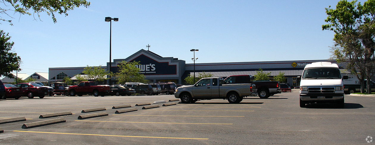
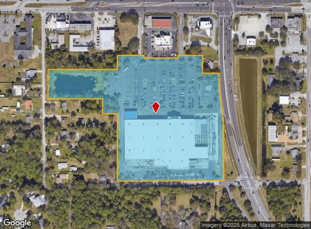
Property Record
2150 Minton Rd, Melbourne, FL 32904
NEARBY LISTINGS FOR SALE OR LEASE
Property Detail
2150 Minton Rd
Palm Bay-Melbourne-Titusville, FL
Feast Groves
28-36-01-75-00000.0-0008.00
FEAST GROVES LOTS 8, 9 & 10 ALSO LOTS 84 THRU 109, LOTS 120 THRU 147, LOTS 158 THRU 171 & VACATED W 1/2 OF AVE B & ALL VACATED AVE C & D AS DESC IN ORB 3824 PG 3925 EXC ORB 7444 PG 1506
Departmentstore
Brevard
X
Florida
12009C0583G
8
2023
16.12 AC
2023
Brevard County
065001
Orlando
151,324 SF
DEMOGRAPHICS near 2150 Minton Rd
1 Mile
3 Mile
5 Mile
2024 Total Population
6,319
48,037
141,712
2029 Population
6,886
52,743
155,231
Pop Growth 2024-2029
+ 8.97%
+ 9.80%
+ 9.54%
Average Age
42
43
43
2024 Total Households
2,458
19,408
58,962
HH Growth 2024-2029
+ 8.71%
+ 9.66%
+ 9.41%
Median Household Inc
$78,757
$71,914
$58,371
Avg Household Size
2.50
2.30
2.30
2024 Avg HH Vehicles
2.00
2.00
2.00
Median Home Value
$322,385
$265,980
$231,089
Median Year Built
1982
1989
1986
Nearby Places
- Restaurants
- Banks
- Shops
- Fitness
- Groceries
PUBLIC TRANSPORTATION
AIRPORT
Melbourne Orlando International
DRIVE
WALK
Distance
Melbourne Orlando International
12 min
4.1 mi
Freight Ports
Port Canaveral
DRIVE
WALK
Distance
Port Canaveral
47 min
36.8 mi
Nearby Properties
Address
Land Use
TOTAL SIZE
Lot Size
Zoning
Address
Land Use
TOTAL SIZE
Lot Size
Zoning
506,643 SF
80 AC
RA
Address
Land Use
TOTAL SIZE
Lot Size
Zoning
433,669 SF
21.22 AC
AU
Address
Land Use
TOTAL SIZE
Lot Size
Zoning
391,740 SF
30 AC
Address
Land Use
TOTAL SIZE
Lot Size
Zoning
582,248 SF
65.30 AC
RA
Address
Land Use
TOTAL SIZE
Lot Size
Zoning
265,272 SF
21.17 AC
M1
Address
Land Use
TOTAL SIZE
Lot Size
Zoning
384,430 SF
33.07 AC
R2
Address
Land Use
TOTAL SIZE
Lot Size
Zoning
253,206 SF
14.75 AC
M1
Address
Land Use
TOTAL SIZE
Lot Size
Zoning
389,175 SF
12.18 AC
Address
Land Use
TOTAL SIZE
Lot Size
Zoning
387,843 SF
27.19 AC
R3
Address
Land Use
TOTAL SIZE
Lot Size
Zoning
198,654 SF
27.99 AC
M1
Address
Land Use
TOTAL SIZE
Lot Size
Zoning
261,552 SF
23.21 AC
R2
Address
Land Use
TOTAL SIZE
Lot Size
Zoning
280,518 SF
13.88 AC
Address
Land Use
TOTAL SIZE
Lot Size
Zoning
542,262 SF
51.88 AC
CP
Address
Land Use
TOTAL SIZE
Lot Size
Zoning
268,487 SF
20.08 AC
RA
Address
Land Use
TOTAL SIZE
Lot Size
Zoning
74,716 SF
366.45 AC
M1
Address
Land Use
TOTAL SIZE
Lot Size
Zoning
225,020 SF
24.25 AC
Address
Land Use
TOTAL SIZE
Lot Size
Zoning
226,121 SF
17.73 AC
Address
Land Use
TOTAL SIZE
Lot Size
Zoning
201,325 SF
11.41 AC
Address
Land Use
TOTAL SIZE
Lot Size
Zoning
205,564 SF
14.56 AC
M1
Address
Land Use
TOTAL SIZE
Lot Size
Zoning
248,019 SF
12.22 AC
P1
Address
Land Use
TOTAL SIZE
Lot Size
Zoning
188,927 SF
17.97 AC
CP
Address
Land Use
TOTAL SIZE
Lot Size
Zoning
175,610 SF
10.01 AC
CCP(15)
Address
Land Use
TOTAL SIZE
Lot Size
Zoning
2,128 SF
6.92 AC
P1
Address
Land Use
TOTAL SIZE
Lot Size
Zoning
326,303 SF
11.22 AC
M1
Address
Land Use
TOTAL SIZE
Lot Size
Zoning
161,528 SF
13.23 AC
CP
Address
Land Use
TOTAL SIZE
Lot Size
Zoning
353,747 SF
54.66 AC
M1
Address
Land Use
TOTAL SIZE
Lot Size
Zoning
35,696 SF
126.83 AC
M1
Address
Land Use
TOTAL SIZE
Lot Size
Zoning
239,767 SF
24.47 AC
M1
Address
Land Use
TOTAL SIZE
Lot Size
Zoning
81,720 SF
13.20 AC
Address
Land Use
TOTAL SIZE
Lot Size
Zoning
95,944 SF
17.22 AC
GU
The World's #1 Commercial Real Estate Marketplace
Connect with us
© 2025 CoStar Group
The information above has been obtained from sources believed reliable. While we do not doubt its accuracy we have not verified it and make no guarantee, warranty or representation about it. It is your responsibility to independently confirm its accuracy and completeness. Any projections, opinions, assumptions, or estimates used are for example only and do not represent the current or future performance of the property. The value of this transaction to you depends on tax and other factors which should be evaluated by your tax, financial, and legal advisors. You and your advisors should conduct a careful, independent investigation of the property to determine to your satisfaction the suitability of the property for your needs.