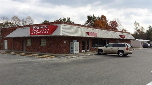
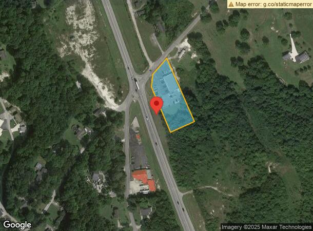
Property Record
2157 S Highway 27, Stearns, KY 42647
NEARBY LISTINGS FOR SALE OR LEASE
-
-
View all Stearns listings for sale on LoopNet.com
Property Detail
2157 S Highway 27
Supermarket
2 TRACTS & COMM BLDG DB 221/791
X
Mccreary
21147C0275C
Kentucky
2023
4 AC
2023
Kentucky East Area
960301
Other Market Areas
6,364 SF
122-30-05-002.00
DEMOGRAPHICS near 2157 S Highway 27
1 Mile
3 Mile
5 Mile
2024 Total Population
742
5,662
11,350
2029 Population
719
5,544
11,137
Pop Growth 2024-2029
(3.10%)
(2.08%)
(1.88%)
Average Age
40
40
40
2024 Total Households
286
2,143
4,050
HH Growth 2024-2029
(3.15%)
(2.19%)
(2.00%)
Median Household Inc
$38,244
$35,839
$35,426
Avg Household Size
2.60
2.40
2.40
2024 Avg HH Vehicles
2.00
2.00
2.00
Median Home Value
$87,606
$81,172
$82,426
Median Year Built
1981
1981
1983
Nearby Places
- Restaurants
- Banks
- Shops
- Fitness
- Groceries
Nearby Properties
Address
Land Use
TOTAL SIZE
Lot Size
Zoning
Address
Land Use
TOTAL SIZE
Lot Size
Zoning
7.34 AC
Address
Land Use
TOTAL SIZE
Lot Size
Zoning
42,224 SF
1.20 AC
Address
Land Use
TOTAL SIZE
Lot Size
Zoning
Address
Land Use
TOTAL SIZE
Lot Size
Zoning
1.05 AC
Address
Land Use
TOTAL SIZE
Lot Size
Zoning
23,402 SF
5.95 AC
Address
Land Use
TOTAL SIZE
Lot Size
Zoning
Address
Land Use
TOTAL SIZE
Lot Size
Zoning
2.32 AC
Address
Land Use
TOTAL SIZE
Lot Size
Zoning
Address
Land Use
TOTAL SIZE
Lot Size
Zoning
Address
Land Use
TOTAL SIZE
Lot Size
Zoning
4,140 SF
0.94 AC
Address
Land Use
TOTAL SIZE
Lot Size
Zoning
11.05 AC
Address
Land Use
TOTAL SIZE
Lot Size
Zoning
60.46 AC
Address
Land Use
TOTAL SIZE
Lot Size
Zoning
10,461 SF
1.29 AC
Address
Land Use
TOTAL SIZE
Lot Size
Zoning
2,400 SF
1.78 AC
Address
Land Use
TOTAL SIZE
Lot Size
Zoning
2.07 AC
Address
Land Use
TOTAL SIZE
Lot Size
Zoning
1.46 AC
Address
Land Use
TOTAL SIZE
Lot Size
Zoning
Address
Land Use
TOTAL SIZE
Lot Size
Zoning
Address
Land Use
TOTAL SIZE
Lot Size
Zoning
Address
Land Use
TOTAL SIZE
Lot Size
Zoning
Address
Land Use
TOTAL SIZE
Lot Size
Zoning
2.91 AC
Address
Land Use
TOTAL SIZE
Lot Size
Zoning
5,250 SF
1.53 AC
Address
Land Use
TOTAL SIZE
Lot Size
Zoning
Address
Land Use
TOTAL SIZE
Lot Size
Zoning
Address
Land Use
TOTAL SIZE
Lot Size
Zoning
3,432 SF
0.70 AC
Address
Land Use
TOTAL SIZE
Lot Size
Zoning
Address
Land Use
TOTAL SIZE
Lot Size
Zoning
2,090 SF
2.30 AC
Address
Land Use
TOTAL SIZE
Lot Size
Zoning
2,520 SF
0.81 AC
Address
Land Use
TOTAL SIZE
Lot Size
Zoning
0.87 AC
The World's #1 Commercial Real Estate Marketplace
Connect with us
© 2025 CoStar Group
The information above has been obtained from sources believed reliable. While we do not doubt its accuracy we have not verified it and make no guarantee, warranty or representation about it. It is your responsibility to independently confirm its accuracy and completeness. Any projections, opinions, assumptions, or estimates used are for example only and do not represent the current or future performance of the property. The value of this transaction to you depends on tax and other factors which should be evaluated by your tax, financial, and legal advisors. You and your advisors should conduct a careful, independent investigation of the property to determine to your satisfaction the suitability of the property for your needs.