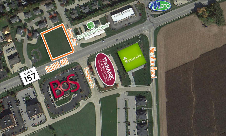
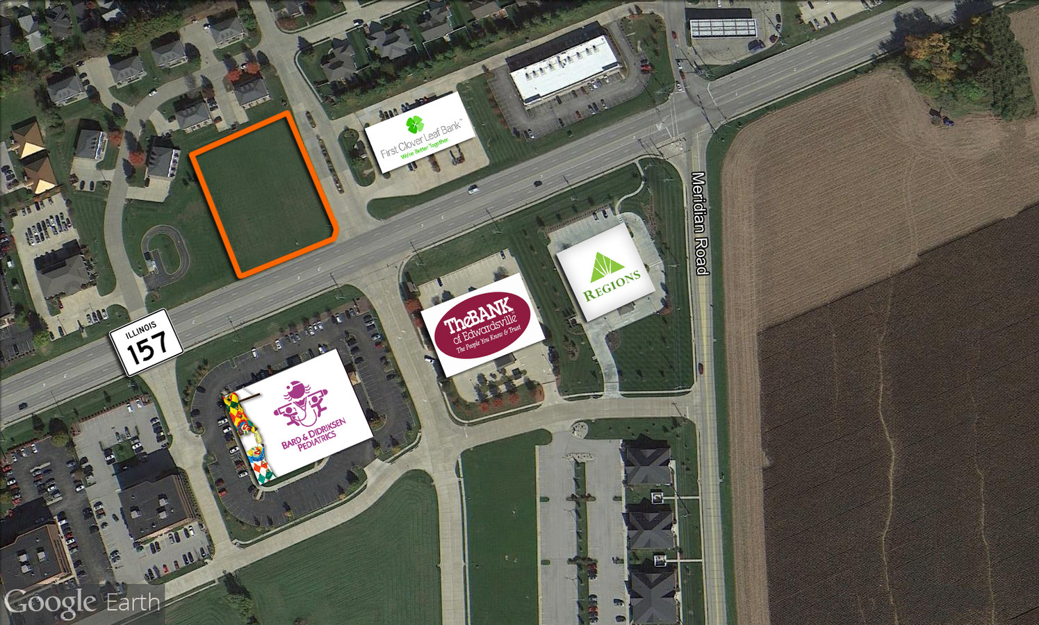
Property Record
2159 S State Route 157, Edwardsville, IL 62025
NEARBY LISTINGS FOR SALE OR LEASE
Property Detail
2159 S State Route 157
St. Louis, MO-IL
FINAL PLAT RESUBD OF LOT 2 - 157 COMMERCIAL PLAZA LOT 2 169.35 X 263.46 IRREGULAR
14-2-15-21-04-404-012
Madison
Commercialnec
Illinois
2023
2
2023
1.14 AC
402900
Illinois
4,820 SF
St. Louis
DEMOGRAPHICS near 2159 S State Route 157
1 Mile
3 Mile
5 Mile
2024 Total Population
4,400
35,942
56,795
2029 Population
4,348
35,707
56,277
Pop Growth 2024-2029
(1.18%)
(0.65%)
(0.91%)
Average Age
39
38
39
2024 Total Households
1,717
13,030
21,429
HH Growth 2024-2029
(1.34%)
(0.61%)
(0.93%)
Median Household Inc
$78,488
$88,201
$87,180
Avg Household Size
2.40
2.40
2.40
2024 Avg HH Vehicles
2.00
2.00
2.00
Median Home Value
$342,947
$260,774
$240,170
Median Year Built
1990
1989
1987
Nearby Places
- Restaurants
- Banks
- Shops
- Fitness
- Groceries
PUBLIC TRANSPORTATION
AIRPORT
St Louis Lambert International
DRIVE
WALK
Distance
St Louis Lambert International
39 min
27.2 mi
Scott AFB/Midamerica St Louis
DRIVE
WALK
Distance
Scott AFB/Midamerica St Louis
49 min
29.2 mi
Freight Ports
Port Milwaukee
DRIVE
WALK
Distance
Port Milwaukee
396 min
347.6 mi
SALE & LEASE HISTORY
LISTING DATE
SALE/LEASE

Sep 24, 2016
For Sale
Nearby Properties
Address
Land Use
TOTAL SIZE
Lot Size
Zoning
Address
Land Use
TOTAL SIZE
Lot Size
Zoning
72,370 SF
26.44 AC
Address
Land Use
TOTAL SIZE
Lot Size
Zoning
75,367 SF
12.25 AC
Address
Land Use
TOTAL SIZE
Lot Size
Zoning
5,181 SF
9.31 AC
Address
Land Use
TOTAL SIZE
Lot Size
Zoning
56,126 SF
10 AC
Address
Land Use
TOTAL SIZE
Lot Size
Zoning
117,068 SF
2.64 AC
Address
Land Use
TOTAL SIZE
Lot Size
Zoning
50,968 SF
4.23 AC
Address
Land Use
TOTAL SIZE
Lot Size
Zoning
48,572 SF
19.78 AC
Address
Land Use
TOTAL SIZE
Lot Size
Zoning
22,486 SF
2.69 AC
Address
Land Use
TOTAL SIZE
Lot Size
Zoning
187,818 SF
12.47 AC
Address
Land Use
TOTAL SIZE
Lot Size
Zoning
209,100 SF
25.87 AC
Address
Land Use
TOTAL SIZE
Lot Size
Zoning
58,359 SF
5 AC
Address
Land Use
TOTAL SIZE
Lot Size
Zoning
77,411 SF
9.11 AC
Address
Land Use
TOTAL SIZE
Lot Size
Zoning
53,192 SF
1.10 AC
Address
Land Use
TOTAL SIZE
Lot Size
Zoning
127,592 SF
11.63 AC
Address
Land Use
TOTAL SIZE
Lot Size
Zoning
131,853 SF
14.60 AC
Address
Land Use
TOTAL SIZE
Lot Size
Zoning
55,292 SF
13.31 AC
Address
Land Use
TOTAL SIZE
Lot Size
Zoning
37,432 SF
2 AC
Address
Land Use
TOTAL SIZE
Lot Size
Zoning
126,578 SF
3.74 AC
Address
Land Use
TOTAL SIZE
Lot Size
Zoning
33,495 SF
0.72 AC
Address
Land Use
TOTAL SIZE
Lot Size
Zoning
48,945 SF
1.56 AC
Address
Land Use
TOTAL SIZE
Lot Size
Zoning
70,484 SF
9.26 AC
Address
Land Use
TOTAL SIZE
Lot Size
Zoning
65,894 SF
9.08 AC
Address
Land Use
TOTAL SIZE
Lot Size
Zoning
89,378 SF
8.56 AC
Address
Land Use
TOTAL SIZE
Lot Size
Zoning
93,098 SF
15.82 AC
Address
Land Use
TOTAL SIZE
Lot Size
Zoning
42,588 SF
4.68 AC
Address
Land Use
TOTAL SIZE
Lot Size
Zoning
17.95 AC
Address
Land Use
TOTAL SIZE
Lot Size
Zoning
93,392 SF
8.17 AC
Address
Land Use
TOTAL SIZE
Lot Size
Zoning
29,577 SF
0.44 AC
Address
Land Use
TOTAL SIZE
Lot Size
Zoning
Address
Land Use
TOTAL SIZE
Lot Size
Zoning
50,690 SF
11.64 AC
The World's #1 Commercial Real Estate Marketplace
Connect with us
© 2025 CoStar Group
The information above has been obtained from sources believed reliable. While we do not doubt its accuracy we have not verified it and make no guarantee, warranty or representation about it. It is your responsibility to independently confirm its accuracy and completeness. Any projections, opinions, assumptions, or estimates used are for example only and do not represent the current or future performance of the property. The value of this transaction to you depends on tax and other factors which should be evaluated by your tax, financial, and legal advisors. You and your advisors should conduct a careful, independent investigation of the property to determine to your satisfaction the suitability of the property for your needs.