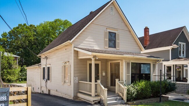
Property Record
216 S Main St, Granville, OH 43023


NEARBY LISTINGS FOR SALE OR LEASE
Property Detail
216 S Main St
Columbus, OH
West Half
020-054192-00.000
LOT 254 PT (OLD LOT 4 BLK 22) PLAT OF GRANVILLE
Commercialnec
Licking
X
Ohio
39089C0309J
254
2024
0.16 AC
2024
Licking County
757702
Columbus
2,148 SF
DEMOGRAPHICS near 216 S Main St
1 Mile
3 Mile
5 Mile
2024 Total Population
3,364
13,678
42,870
2029 Population
3,508
14,261
44,753
Pop Growth 2024-2029
+ 4.28%
+ 4.26%
+ 4.39%
Average Age
38
38
41
2024 Total Households
1,147
4,458
16,607
HH Growth 2024-2029
+ 5.06%
+ 4.69%
+ 4.56%
Median Household Inc
$119,504
$121,584
$74,212
Avg Household Size
2.30
2.60
2.40
2024 Avg HH Vehicles
2.00
2.00
2.00
Median Home Value
$399,999
$355,663
$218,476
Median Year Built
1970
1979
1973
Nearby Places
Map Layers
Map Styles
 Street
 Aerial
- Restaurants
- Banks
- Shops
- Fitness
- Groceries
PUBLIC TRANSPORTATION
AIRPORT
John Glenn Columbus International
DRIVE
WALK
Distance
John Glenn Columbus International
37 min
23.8 mi
Rickenbacker International
DRIVE
WALK
Distance
Rickenbacker International
47 min
33.4 mi
SALE & LEASE HISTORY
LISTING DATE
SALE/LEASE

Oct 10, 2025
For Sale
Jul 28, 2022
For Sale
Nearby Properties
Address
Land Use
TOTAL SIZE
Lot Size
Zoning
Address
Land Use
TOTAL SIZE
Lot Size
Zoning
58,736 SF
125.87 AC
Address
Land Use
TOTAL SIZE
Lot Size
Zoning
19,176 SF
16.50 AC
Address
Land Use
TOTAL SIZE
Lot Size
Zoning
38,400 SF
7.87 AC
Address
Land Use
TOTAL SIZE
Lot Size
Zoning
17,550 SF
7 AC
Address
Land Use
TOTAL SIZE
Lot Size
Zoning
27,122 SF
1.92 AC
Address
Land Use
TOTAL SIZE
Lot Size
Zoning
64,828 SF
30 AC
Address
Land Use
TOTAL SIZE
Lot Size
Zoning
19,808 SF
60.50 AC
Address
Land Use
TOTAL SIZE
Lot Size
Zoning
29,002 SF
179 AC
Address
Land Use
TOTAL SIZE
Lot Size
Zoning
18,033 SF
3 AC
Address
Land Use
TOTAL SIZE
Lot Size
Zoning
3,778 SF
3.78 AC
Address
Land Use
TOTAL SIZE
Lot Size
Zoning
92,329 SF
12.86 AC
Address
Land Use
TOTAL SIZE
Lot Size
Zoning
205.82 AC
Address
Land Use
TOTAL SIZE
Lot Size
Zoning
56,464 SF
16.75 AC
Address
Land Use
TOTAL SIZE
Lot Size
Zoning
34,298 SF
11.40 AC
Address
Land Use
TOTAL SIZE
Lot Size
Zoning
888 SF
14.60 AC
Address
Land Use
TOTAL SIZE
Lot Size
Zoning
34,893 SF
1.16 AC
Address
Land Use
TOTAL SIZE
Lot Size
Zoning
55,369 SF
16.11 AC
Address
Land Use
TOTAL SIZE
Lot Size
Zoning
270 SF
27.60 AC
Address
Land Use
TOTAL SIZE
Lot Size
Zoning
22,127 SF
2.50 AC
Address
Land Use
TOTAL SIZE
Lot Size
Zoning
2,629 SF
18.04 AC
Address
Land Use
TOTAL SIZE
Lot Size
Zoning
29,748 SF
5.76 AC
Address
Land Use
TOTAL SIZE
Lot Size
Zoning
8,376 SF
8.22 AC
Address
Land Use
TOTAL SIZE
Lot Size
Zoning
4,436 SF
58.08 AC
Address
Land Use
TOTAL SIZE
Lot Size
Zoning
10,830 SF
5.50 AC
Address
Land Use
TOTAL SIZE
Lot Size
Zoning
14,596 SF
0.32 AC
Address
Land Use
TOTAL SIZE
Lot Size
Zoning
10,620 SF
4.24 AC
Address
Land Use
TOTAL SIZE
Lot Size
Zoning
30.69 AC
Address
Land Use
TOTAL SIZE
Lot Size
Zoning
19,041 SF
1.70 AC
Address
Land Use
TOTAL SIZE
Lot Size
Zoning
3,900 SF
4.74 AC
Address
Land Use
TOTAL SIZE
Lot Size
Zoning
1,252,804 SF
4.37 AC
The World's #1 Commercial Real Estate Marketplace
Connect with us
© 2025 CoStar Group
The information above has been obtained from sources believed reliable. While we do not doubt its accuracy we have not verified it and make no guarantee, warranty or representation about it. It is your responsibility to independently confirm its accuracy and completeness. Any projections, opinions, assumptions, or estimates used are for example only and do not represent the current or future performance of the property. The value of this transaction to you depends on tax and other factors which should be evaluated by your tax, financial, and legal advisors. You and your advisors should conduct a careful, independent investigation of the property to determine to your satisfaction the suitability of the property for your needs.