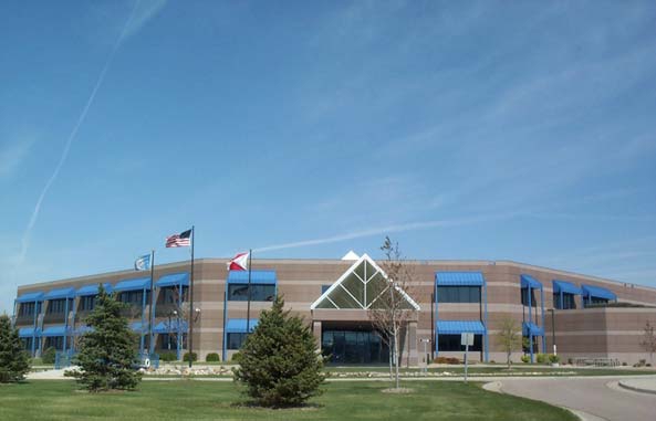
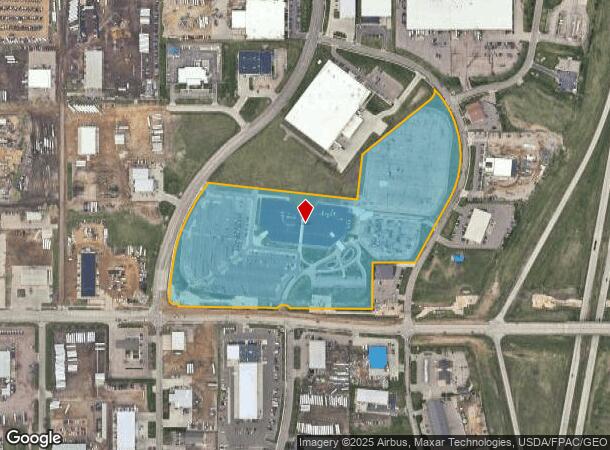
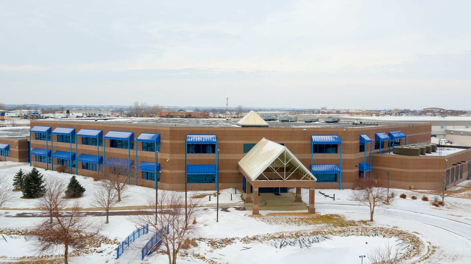
Property Record
2200 E Benson Rd, Sioux Falls, SD 57104

NEARBY LISTINGS FOR SALE OR LEASE
Property Detail
2200 E Benson Rd
66977
Park Four Addn
Officebuilding
TRACT D1 (EX LOT H1) SIOUX EMPIRE DEVELOPMENT PARK FOUR ADDN TO SIOUX FALLS
X
Minnehaha
46099C0454F
South Dakota
2024
24.98 AC
2023
Sioux Falls
000100
Other Market Areas
50,160 SF
Sioux Falls, SD
DEMOGRAPHICS near 2200 E Benson Rd
1 Mile
3 Mile
5 Mile
2024 Total Population
1,442
25,855
90,789
2029 Population
1,527
27,946
98,565
Pop Growth 2024-2029
+ 5.89%
+ 8.09%
+ 8.56%
Average Age
42
38
38
2024 Total Households
586
9,621
37,110
HH Growth 2024-2029
+ 5.80%
+ 8.70%
+ 9.04%
Median Household Inc
$39,999
$59,520
$62,006
Avg Household Size
2.40
2.40
2.30
2024 Avg HH Vehicles
2.00
2.00
2.00
Median Home Value
$118,064
$188,717
$218,323
Median Year Built
1979
1981
1975
Nearby Places
- Restaurants
- Banks
- Shops
- Fitness
- Groceries
PUBLIC TRANSPORTATION
AIRPORT
Joe Foss Field
DRIVE
WALK
Distance
Joe Foss Field
22 min
6.1 mi
Freight Ports
Port Milwaukee
DRIVE
WALK
Distance
Port Milwaukee
542 min
500.1 mi
SALE & LEASE HISTORY
LISTING DATE
SALE/LEASE

Sep 25, 2016
For Lease
Feb 01, 2017
For Sale
Nearby Properties
Address
Land Use
TOTAL SIZE
Lot Size
Zoning
Address
Land Use
TOTAL SIZE
Lot Size
Zoning
8.90 AC
C1;NEIGHBO
Address
Land Use
TOTAL SIZE
Lot Size
Zoning
14,820 SF
80.57 AC
FP;FP
Address
Land Use
TOTAL SIZE
Lot Size
Zoning
1.57 AC
C2;GENERAL
Address
Land Use
TOTAL SIZE
Lot Size
Zoning
300,920 SF
90.58 AC
Address
Land Use
TOTAL SIZE
Lot Size
Zoning
1,806 SF
170.92 AC
FP;FP
Address
Land Use
TOTAL SIZE
Lot Size
Zoning
1,860 SF
86.79 AC
Address
Land Use
TOTAL SIZE
Lot Size
Zoning
1,872 SF
26.52 AC
Address
Land Use
TOTAL SIZE
Lot Size
Zoning
Address
Land Use
TOTAL SIZE
Lot Size
Zoning
1,020 SF
27.39 AC
NO;SPECIAL
Address
Land Use
TOTAL SIZE
Lot Size
Zoning
7,072 SF
2.94 AC
Address
Land Use
TOTAL SIZE
Lot Size
Zoning
62,056 SF
2.68 AC
Address
Land Use
TOTAL SIZE
Lot Size
Zoning
41.01 AC
FP;FP
Address
Land Use
TOTAL SIZE
Lot Size
Zoning
71,471 SF
5.56 AC
Address
Land Use
TOTAL SIZE
Lot Size
Zoning
19,138 SF
4.26 AC
Address
Land Use
TOTAL SIZE
Lot Size
Zoning
44,063 SF
17.43 AC
Address
Land Use
TOTAL SIZE
Lot Size
Zoning
348,059 SF
32.99 AC
Address
Land Use
TOTAL SIZE
Lot Size
Zoning
38.29 AC
Address
Land Use
TOTAL SIZE
Lot Size
Zoning
238,875 SF
21.92 AC
NO;SPECIAL
Address
Land Use
TOTAL SIZE
Lot Size
Zoning
62,056 SF
3.25 AC
Address
Land Use
TOTAL SIZE
Lot Size
Zoning
24,400 SF
11.47 AC
Address
Land Use
TOTAL SIZE
Lot Size
Zoning
145,014 SF
14.41 AC
Address
Land Use
TOTAL SIZE
Lot Size
Zoning
24,050 SF
7.92 AC
Address
Land Use
TOTAL SIZE
Lot Size
Zoning
71,658 SF
8.93 AC
Address
Land Use
TOTAL SIZE
Lot Size
Zoning
68.33 AC
Address
Land Use
TOTAL SIZE
Lot Size
Zoning
18.37 AC
Address
Land Use
TOTAL SIZE
Lot Size
Zoning
149,520 SF
22.50 AC
Address
Land Use
TOTAL SIZE
Lot Size
Zoning
127,332 SF
28.18 AC
Address
Land Use
TOTAL SIZE
Lot Size
Zoning
33,416 SF
9.87 AC
Address
Land Use
TOTAL SIZE
Lot Size
Zoning
26.44 AC
The World's #1 Commercial Real Estate Marketplace
Connect with us
© 2025 CoStar Group
The information above has been obtained from sources believed reliable. While we do not doubt its accuracy we have not verified it and make no guarantee, warranty or representation about it. It is your responsibility to independently confirm its accuracy and completeness. Any projections, opinions, assumptions, or estimates used are for example only and do not represent the current or future performance of the property. The value of this transaction to you depends on tax and other factors which should be evaluated by your tax, financial, and legal advisors. You and your advisors should conduct a careful, independent investigation of the property to determine to your satisfaction the suitability of the property for your needs.