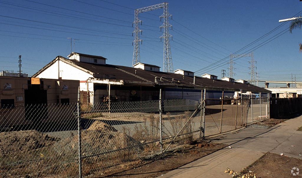
Property Record
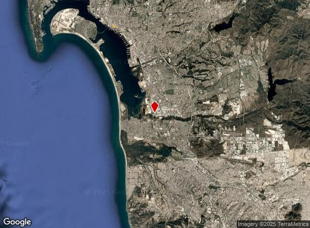
2201 Main St, San Diego, CA 92154
NEARBY LISTINGS FOR SALE OR LEASE
Property Detail
2201 Main St
San Diego-Carlsbad, CA
S D Land & Town Co Add
538-790-12
BLK 79 LOTS 25 THRU 48 ST CLSD BET BLKS 78&79 & ALLEY CLSD ADJ& TR 000379
Industrialacreage
San Diego
X
California
06073C1884H
25-48
2024
2.27 AC
2024
Southeast San Diego
013205
San Diego
DEMOGRAPHICS near 2201 Main St
1 Mile
3 Mile
5 Mile
2024 Total Population
19,762
181,372
456,122
2029 Population
19,593
181,692
454,755
Pop Growth 2024-2029
(0.86%)
+ 0.18%
(0.30%)
Average Age
37
38
38
2024 Total Households
5,433
71,845
176,518
HH Growth 2024-2029
(0.99%)
+ 0.54%
(0.17%)
Median Household Inc
$46,170
$70,376
$70,820
Avg Household Size
3.00
2.20
2.40
2024 Avg HH Vehicles
1.00
1.00
2.00
Median Home Value
$606,498
$802,646
$713,993
Median Year Built
1962
1980
1973
Nearby Places
- Restaurants
- Banks
- Shops
- Fitness
- Groceries
PUBLIC TRANSPORTATION
TRANSIT/SUBWAY
Palomar Street (Blue Line - San Diego Metropolitan Transit System Trolley (San Diego Trolley))
DRIVE
WALK
Distance
Palomar Street (Blue Line - San Diego Metropolitan Transit System Trolley (San Diego Trolley))
2 min
17 min
0.9 mi
Palm Avenue (Blue Line - San Diego Metropolitan Transit System Trolley (San Diego Trolley))
DRIVE
WALK
Distance
Palm Avenue (Blue Line - San Diego Metropolitan Transit System Trolley (San Diego Trolley))
3 min
20 min
1.0 mi
AIRPORT
San Diego International
DRIVE
WALK
Distance
San Diego International
18 min
14.1 mi
Freight Ports
Port of San Diego
DRIVE
WALK
Distance
Port of San Diego
14 min
10.1 mi
Nearby Properties
Address
Land Use
TOTAL SIZE
Lot Size
Zoning
Address
Land Use
TOTAL SIZE
Lot Size
Zoning
11.42 AC
CP
Address
Land Use
TOTAL SIZE
Lot Size
Zoning
8.60 AC
RM-2-5
Address
Land Use
TOTAL SIZE
Lot Size
Zoning
25.35 AC
UC-7
Address
Land Use
TOTAL SIZE
Lot Size
Zoning
11,742 SF
14.37 AC
RM-2-5
Address
Land Use
TOTAL SIZE
Lot Size
Zoning
15 AC
UC-14
Address
Land Use
TOTAL SIZE
Lot Size
Zoning
8.48 AC
RM-2-5
Address
Land Use
TOTAL SIZE
Lot Size
Zoning
12.72 AC
IBT-1-1
Address
Land Use
TOTAL SIZE
Lot Size
Zoning
12.68 AC
I-7
Address
Land Use
TOTAL SIZE
Lot Size
Zoning
8.96 AC
C-6
Address
Land Use
TOTAL SIZE
Lot Size
Zoning
6.03 AC
R3
Address
Land Use
TOTAL SIZE
Lot Size
Zoning
2.81 AC
I-7
Address
Land Use
TOTAL SIZE
Lot Size
Zoning
6.67 AC
RM-2-5
Address
Land Use
TOTAL SIZE
Lot Size
Zoning
4.70 AC
R3
Address
Land Use
TOTAL SIZE
Lot Size
Zoning
77,397 SF
4.10 AC
R3
Address
Land Use
TOTAL SIZE
Lot Size
Zoning
7.52 AC
CTP
Address
Land Use
TOTAL SIZE
Lot Size
Zoning
7.36 AC
RM-2-5
Address
Land Use
TOTAL SIZE
Lot Size
Zoning
1.05 AC
C-6
Address
Land Use
TOTAL SIZE
Lot Size
Zoning
74,988 SF
10.74 AC
RM-2-4
Address
Land Use
TOTAL SIZE
Lot Size
Zoning
77,573 SF
1.13 AC
C/MU-2
Address
Land Use
TOTAL SIZE
Lot Size
Zoning
5.28 AC
CC-4-5
Address
Land Use
TOTAL SIZE
Lot Size
Zoning
9.10 AC
RM-1-1
Address
Land Use
TOTAL SIZE
Lot Size
Zoning
1.43 AC
C-6
Address
Land Use
TOTAL SIZE
Lot Size
Zoning
1.43 AC
UC-2
Address
Land Use
TOTAL SIZE
Lot Size
Zoning
9.92 AC
RM-1-1
Address
Land Use
TOTAL SIZE
Lot Size
Zoning
4.71 AC
R3
Address
Land Use
TOTAL SIZE
Lot Size
Zoning
2.27 AC
IBT-1-1
Address
Land Use
TOTAL SIZE
Lot Size
Zoning
67,850 SF
4.90 AC
RM-1-1
Address
Land Use
TOTAL SIZE
Lot Size
Zoning
4.28 AC
R3
Address
Land Use
TOTAL SIZE
Lot Size
Zoning
12.86 AC
CCP
Address
Land Use
TOTAL SIZE
Lot Size
Zoning
4.38 AC
RM-2-5
The World's #1 Commercial Real Estate Marketplace
Connect with us
© 2025 CoStar Group
The information above has been obtained from sources believed reliable. While we do not doubt its accuracy we have not verified it and make no guarantee, warranty or representation about it. It is your responsibility to independently confirm its accuracy and completeness. Any projections, opinions, assumptions, or estimates used are for example only and do not represent the current or future performance of the property. The value of this transaction to you depends on tax and other factors which should be evaluated by your tax, financial, and legal advisors. You and your advisors should conduct a careful, independent investigation of the property to determine to your satisfaction the suitability of the property for your needs.