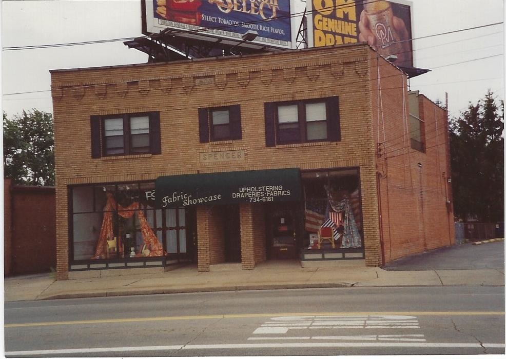
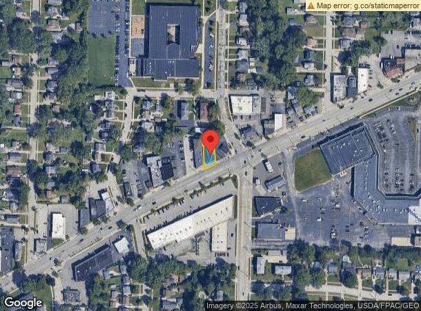
Property Record
22008 Lorain Rd, Cleveland, OH 44126
NEARBY LISTINGS FOR SALE OR LEASE
Property Detail
22008 Lorain Rd
Cleveland-Elyria, OH
C H Spencer Subdivision
321-09-020
6 SPENCER 0002 ALL
Retailwithmorethanonenonretailuse
Cuyahoga
X
Ohio
39035C0153E
2
2024
0.14 AC
2024
West
153104
Cleveland
6,156 SF
DEMOGRAPHICS near 22008 Lorain Rd
1 Mile
3 Mile
5 Mile
2024 Total Population
13,240
78,065
215,826
2029 Population
12,815
75,912
209,487
Pop Growth 2024-2029
(3.21%)
(2.76%)
(2.94%)
Average Age
43
43
42
2024 Total Households
5,671
34,707
95,468
HH Growth 2024-2029
(3.42%)
(2.95%)
(3.14%)
Median Household Inc
$82,250
$74,131
$68,463
Avg Household Size
2.30
2.20
2.20
2024 Avg HH Vehicles
2.00
2.00
2.00
Median Home Value
$188,497
$208,931
$190,823
Median Year Built
1957
1960
1957
Nearby Places
- Restaurants
- Banks
- Shops
- Fitness
- Groceries
PUBLIC TRANSPORTATION
AIRPORT
Cleveland-Hopkins International
DRIVE
WALK
Distance
Cleveland-Hopkins International
8 min
2.8 mi
Freight Ports
Port of Toledo
DRIVE
WALK
Distance
Port of Toledo
122 min
101.8 mi
SALE & LEASE HISTORY
LISTING DATE
SALE/LEASE

Sep 09, 2019
For Sale
Nearby Properties
Address
Land Use
TOTAL SIZE
Lot Size
Zoning
Address
Land Use
TOTAL SIZE
Lot Size
Zoning
748.88 AC
GI
Address
Land Use
TOTAL SIZE
Lot Size
Zoning
1,669,041 SF
169.42 AC
U6
Address
Land Use
TOTAL SIZE
Lot Size
Zoning
754.68 AC
GI
Address
Land Use
TOTAL SIZE
Lot Size
Zoning
263,090 SF
33.53 AC
GB-A
Address
Land Use
TOTAL SIZE
Lot Size
Zoning
526.33 AC
GI
Address
Land Use
TOTAL SIZE
Lot Size
Zoning
780,869 SF
14.77 AC
LR
Address
Land Use
TOTAL SIZE
Lot Size
Zoning
208.22 AC
U5-A
Address
Land Use
TOTAL SIZE
Lot Size
Zoning
318,724 SF
41.71 AC
EI
Address
Land Use
TOTAL SIZE
Lot Size
Zoning
657,013 SF
48.88 AC
SI
Address
Land Use
TOTAL SIZE
Lot Size
Zoning
89,195 SF
1.58 AC
1F-R1
Address
Land Use
TOTAL SIZE
Lot Size
Zoning
Address
Land Use
TOTAL SIZE
Lot Size
Zoning
633,719 SF
17.16 AC
CRG
Address
Land Use
TOTAL SIZE
Lot Size
Zoning
53,718 SF
2.19 AC
PF
Address
Land Use
TOTAL SIZE
Lot Size
Zoning
63,139 SF
1.52 AC
PF
Address
Land Use
TOTAL SIZE
Lot Size
Zoning
243,118 SF
15.01 AC
PF
Address
Land Use
TOTAL SIZE
Lot Size
Zoning
217,747 SF
29.07 AC
GB-A
Address
Land Use
TOTAL SIZE
Lot Size
Zoning
326,357 SF
6.40 AC
GB
Address
Land Use
TOTAL SIZE
Lot Size
Zoning
3.53 AC
SI
Address
Land Use
TOTAL SIZE
Lot Size
Zoning
49.67 AC
SI
Address
Land Use
TOTAL SIZE
Lot Size
Zoning
364,000 SF
33.27 AC
U5-A
Address
Land Use
TOTAL SIZE
Lot Size
Zoning
14.60 AC
1F-4
Address
Land Use
TOTAL SIZE
Lot Size
Zoning
355,242 SF
13.28 AC
RMF-HR
Address
Land Use
TOTAL SIZE
Lot Size
Zoning
162,449 SF
23.90 AC
PF
Address
Land Use
TOTAL SIZE
Lot Size
Zoning
25,814 SF
64.97 AC
2F
Address
Land Use
TOTAL SIZE
Lot Size
Zoning
90,324 SF
6.71 AC
GR
Address
Land Use
TOTAL SIZE
Lot Size
Zoning
235,984 SF
17.72 AC
GB
Address
Land Use
TOTAL SIZE
Lot Size
Zoning
103.89 AC
U5-A
Address
Land Use
TOTAL SIZE
Lot Size
Zoning
102,512 SF
5.17 AC
CR
Address
Land Use
TOTAL SIZE
Lot Size
Zoning
107,866 SF
11.22 AC
PF
Address
Land Use
TOTAL SIZE
Lot Size
Zoning
24.55 AC
GI
The World's #1 Commercial Real Estate Marketplace
Connect with us
© 2025 CoStar Group
The information above has been obtained from sources believed reliable. While we do not doubt its accuracy we have not verified it and make no guarantee, warranty or representation about it. It is your responsibility to independently confirm its accuracy and completeness. Any projections, opinions, assumptions, or estimates used are for example only and do not represent the current or future performance of the property. The value of this transaction to you depends on tax and other factors which should be evaluated by your tax, financial, and legal advisors. You and your advisors should conduct a careful, independent investigation of the property to determine to your satisfaction the suitability of the property for your needs.