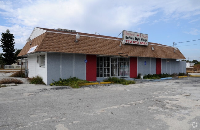
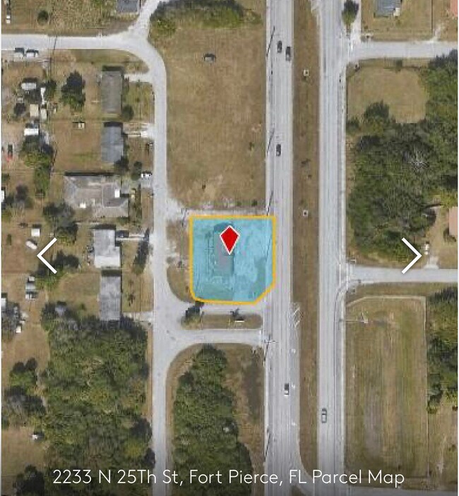
Property Record
2233 N 25Th St, Fort Pierce, FL 34946


NEARBY LISTINGS FOR SALE OR LEASE
Property Detail
2233 N 25Th St
Port St Lucie, FL
Sheraton Plaza Unit 1
14-32-801-0002-0209
SHERATON PLAZA-UNIT ONE- S 126.01 FT OF TRACT B-LESS RD R/W
Storemultistory
St Lucie
X
Florida
12111C0176K
b
2024
0.30 AC
2025
Fort Pierce
380902
Port St Lucie/Fort Pierce
2,176 SF
DEMOGRAPHICS near 2233 N 25Th St
1 Mile
3 Mile
5 Mile
2024 Total Population
9,068
36,226
79,736
2029 Population
10,901
43,634
97,309
Pop Growth 2024-2029
+ 20.21%
+ 20.45%
+ 22.04%
Average Age
36
38
43
2024 Total Households
3,292
13,260
31,251
HH Growth 2024-2029
+ 19.93%
+ 20.24%
+ 22.26%
Median Household Inc
$33,632
$33,930
$48,339
Avg Household Size
2.60
2.60
2.40
2024 Avg HH Vehicles
1.00
1.00
2.00
Median Home Value
$83,897
$155,194
$262,548
Median Year Built
1971
1973
1982
Nearby Places
Map Layers
Map Styles
 Street
 Aerial
- Restaurants
- Banks
- Shops
- Fitness
- Groceries
SALE & LEASE HISTORY
LISTING DATE
SALE/LEASE

Jan 15, 2024
For Sale
Jan 15, 2023
For Sale
Nearby Properties
Address
Land Use
TOTAL SIZE
Lot Size
Zoning
Address
Land Use
TOTAL SIZE
Lot Size
Zoning
206,371 SF
22.36 AC
OFFICE CO
Address
Land Use
TOTAL SIZE
Lot Size
Zoning
222,960 SF
36.34 AC
INDUSTRIAL
Address
Land Use
TOTAL SIZE
Lot Size
Zoning
282,450 SF
68.87 AC
INDUSTRIAL
Address
Land Use
TOTAL SIZE
Lot Size
Zoning
10.32 AC
Address
Land Use
TOTAL SIZE
Lot Size
Zoning
54,826 SF
353 AC
UTILITIES
Address
Land Use
TOTAL SIZE
Lot Size
Zoning
212,073 SF
58 AC
INSTITUTIO
Address
Land Use
TOTAL SIZE
Lot Size
Zoning
51,838 SF
1.62 AC
CENTRAL CO
Address
Land Use
TOTAL SIZE
Lot Size
Zoning
69,970 SF
2.54 AC
GENERAL CO
Address
Land Use
TOTAL SIZE
Lot Size
Zoning
13,280 SF
12.46 AC
GENERAL &
Address
Land Use
TOTAL SIZE
Lot Size
Zoning
30,097 SF
6.37 AC
GENERAL CO
Address
Land Use
TOTAL SIZE
Lot Size
Zoning
170,940 SF
18.16 AC
INDUSTRIAL
Address
Land Use
TOTAL SIZE
Lot Size
Zoning
213,311 SF
20.41 AC
INDUSTRIAL
Address
Land Use
TOTAL SIZE
Lot Size
Zoning
17,273 SF
13.49 AC
GENERAL &
Address
Land Use
TOTAL SIZE
Lot Size
Zoning
276,524 SF
53.32 AC
SF LOW DEN
Address
Land Use
TOTAL SIZE
Lot Size
Zoning
55,046 SF
1.86 AC
GENERAL CO
Address
Land Use
TOTAL SIZE
Lot Size
Zoning
Address
Land Use
TOTAL SIZE
Lot Size
Zoning
1,440 SF
28.47 AC
PUD
Address
Land Use
TOTAL SIZE
Lot Size
Zoning
31,915 SF
2.86 AC
MEDIUM DEN
Address
Land Use
TOTAL SIZE
Lot Size
Zoning
0.02 AC
Address
Land Use
TOTAL SIZE
Lot Size
Zoning
12,517 SF
5.85 AC
GENERAL &
Address
Land Use
TOTAL SIZE
Lot Size
Zoning
61,642 SF
8.46 AC
MEDIUM DEN
Address
Land Use
TOTAL SIZE
Lot Size
Zoning
117,205 SF
8.65 AC
MEDIUM DEN
Address
Land Use
TOTAL SIZE
Lot Size
Zoning
92,208 SF
16.80 AC
MEDIUM DEN
Address
Land Use
TOTAL SIZE
Lot Size
Zoning
65,440 SF
9.83 AC
GENERAL CO
Address
Land Use
TOTAL SIZE
Lot Size
Zoning
1,343 SF
5.33 AC
MARINE IND
Address
Land Use
TOTAL SIZE
Lot Size
Zoning
4,730 SF
7.44 AC
PUD
Address
Land Use
TOTAL SIZE
Lot Size
Zoning
38,158 SF
4.10 AC
CG - CO
Address
Land Use
TOTAL SIZE
Lot Size
Zoning
42,994 SF
6.66 AC
MEDIUM DEN
Address
Land Use
TOTAL SIZE
Lot Size
Zoning
59,190 SF
9.24 AC
MEDIUM DEN
Address
Land Use
TOTAL SIZE
Lot Size
Zoning
151,710 SF
7.30 AC
INDUSTRIAL
The World's #1 Commercial Real Estate Marketplace
Connect with us
© 2025 CoStar Group
The information above has been obtained from sources believed reliable. While we do not doubt its accuracy we have not verified it and make no guarantee, warranty or representation about it. It is your responsibility to independently confirm its accuracy and completeness. Any projections, opinions, assumptions, or estimates used are for example only and do not represent the current or future performance of the property. The value of this transaction to you depends on tax and other factors which should be evaluated by your tax, financial, and legal advisors. You and your advisors should conduct a careful, independent investigation of the property to determine to your satisfaction the suitability of the property for your needs.