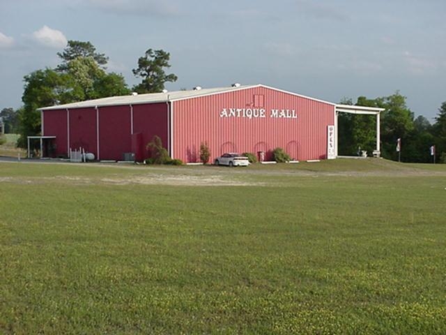
Property Record
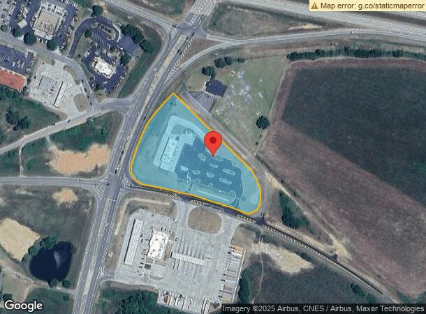
2242 Us Highway 441 S, Dublin, GA 31021
NEARBY LISTINGS FOR SALE OR LEASE
Property Detail
2242 Us Highway 441 S
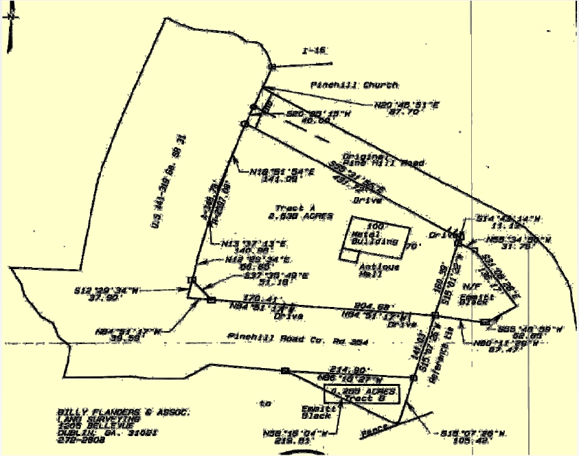
129-115
PLATS 9/569A & 1715/281
Commercialacreage
Laurens
X
Georgia
13175C0306C
67
2024
2.92 AC
2024
Georgia South Area
950800
Other Market Areas
7,000 SF
Dublin, GA
DEMOGRAPHICS near 2242 Us Highway 441 S
1 Mile
3 Mile
5 Mile
2024 Total Population
354
3,248
19,285
2029 Population
355
3,242
19,364
Pop Growth 2024-2029
+ 0.28%
(0.18%)
+ 0.41%
Average Age
42
42
41
2024 Total Households
138
1,247
7,686
HH Growth 2024-2029
+ 0.72%
(0.08%)
+ 0.44%
Median Household Inc
$41,363
$34,682
$35,954
Avg Household Size
2.40
2.40
2.40
2024 Avg HH Vehicles
2.00
2.00
2.00
Median Home Value
$131,395
$126,094
$133,362
Median Year Built
1985
1983
1980
Nearby Places
- Restaurants
- Banks
- Shops
- Fitness
- Groceries
Nearby Properties
Address
Land Use
TOTAL SIZE
Lot Size
Zoning
Address
Land Use
TOTAL SIZE
Lot Size
Zoning
448 SF
95 AC
COMMERCIAL
Address
Land Use
TOTAL SIZE
Lot Size
Zoning
598,082 SF
133.35 AC
INDUSTRIAL
Address
Land Use
TOTAL SIZE
Lot Size
Zoning
372,555 SF
53.17 AC
UNZONED RU
Address
Land Use
TOTAL SIZE
Lot Size
Zoning
484,158 SF
116.80 AC
INDUSTRIAL
Address
Land Use
TOTAL SIZE
Lot Size
Zoning
156,672 SF
41.75 AC
RESIDENTIA
Address
Land Use
TOTAL SIZE
Lot Size
Zoning
269,114 SF
43.42 AC
INDUSTRIAL
Address
Land Use
TOTAL SIZE
Lot Size
Zoning
28,160 SF
28.64 AC
INDUSTRIAL
Address
Land Use
TOTAL SIZE
Lot Size
Zoning
47,421 SF
1.57 AC
COMMERCIAL
Address
Land Use
TOTAL SIZE
Lot Size
Zoning
45,036 SF
2.10 AC
UNZONED SU
Address
Land Use
TOTAL SIZE
Lot Size
Zoning
38,079 SF
1.20 AC
COMMERCIAL
Address
Land Use
TOTAL SIZE
Lot Size
Zoning
49,962 SF
3.07 AC
COMMERCIAL
Address
Land Use
TOTAL SIZE
Lot Size
Zoning
388,955 SF
39.01 AC
INDUSTRIAL
Address
Land Use
TOTAL SIZE
Lot Size
Zoning
12,048 SF
40 AC
UNZONED RU
Address
Land Use
TOTAL SIZE
Lot Size
Zoning
299,250 SF
26.72 AC
INDUSTRIAL
Address
Land Use
TOTAL SIZE
Lot Size
Zoning
173,468 SF
18.75 AC
RESIDENTIA
Address
Land Use
TOTAL SIZE
Lot Size
Zoning
78,501 SF
18.52 AC
UNZONED SU
Address
Land Use
TOTAL SIZE
Lot Size
Zoning
80,000 SF
25.50 AC
INDUSTRIAL
Address
Land Use
TOTAL SIZE
Lot Size
Zoning
60,000 SF
22.44 AC
COMMERCIAL
Address
Land Use
TOTAL SIZE
Lot Size
Zoning
37,136 SF
4.92 AC
COMMERCIAL
Address
Land Use
TOTAL SIZE
Lot Size
Zoning
7,500 SF
60 AC
RESIDENTIA
Address
Land Use
TOTAL SIZE
Lot Size
Zoning
70,680 SF
22.72 AC
RESIDENTIA
Address
Land Use
TOTAL SIZE
Lot Size
Zoning
30,232 SF
4.09 AC
COMMERCIAL
Address
Land Use
TOTAL SIZE
Lot Size
Zoning
8,613 SF
5.05 AC
COMMERCIAL
Address
Land Use
TOTAL SIZE
Lot Size
Zoning
4,234 SF
4.99 AC
RESIDENTIA
Address
Land Use
TOTAL SIZE
Lot Size
Zoning
35,120 SF
10.06 AC
UNZONED RU
Address
Land Use
TOTAL SIZE
Lot Size
Zoning
73,260 SF
7.50 AC
INDUSTRIAL
Address
Land Use
TOTAL SIZE
Lot Size
Zoning
14,478 SF
6.96 AC
COMMERCIAL
Address
Land Use
TOTAL SIZE
Lot Size
Zoning
28,248 SF
21.06 AC
COMMERCIAL
Address
Land Use
TOTAL SIZE
Lot Size
Zoning
19,880 SF
8.65 AC
COMMERCIAL
Address
Land Use
TOTAL SIZE
Lot Size
Zoning
71,675 SF
8 AC
RESIDENTIA
The World's #1 Commercial Real Estate Marketplace
Connect with us
© 2025 CoStar Group
The information above has been obtained from sources believed reliable. While we do not doubt its accuracy we have not verified it and make no guarantee, warranty or representation about it. It is your responsibility to independently confirm its accuracy and completeness. Any projections, opinions, assumptions, or estimates used are for example only and do not represent the current or future performance of the property. The value of this transaction to you depends on tax and other factors which should be evaluated by your tax, financial, and legal advisors. You and your advisors should conduct a careful, independent investigation of the property to determine to your satisfaction the suitability of the property for your needs.