Property Record
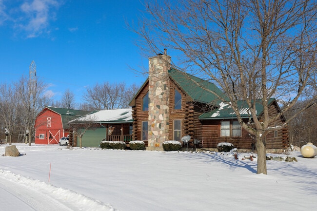
22495 24 Mile Rd, Macomb, MI 48042

NEARBY LISTINGS FOR SALE OR LEASE
-
-
View all Macomb listings for sale on LoopNet.com
Property Detail
22495 24 Mile Rd
20-08-11-400-007
SEC 11; SW 1/4 OF SE 1/4 SEC 11 EXC BEG AT S 1/4 POST SEC 11; TH N0*26'29"W 1322.65 FT ALG N-S 1/4 LINE; TH N89*50'- 09"E
Sfr
Macomb
X
Michigan
26099C0235G
10.82 AC
2025
Macomb East
2025
Detroit
223901
Detroit-Warren-Dearborn, MI
2,088 SF
DEMOGRAPHICS near 22495 24 Mile Rd
1 Mile
3 Mile
5 Mile
2024 Total Population
1,147
32,861
123,480
2029 Population
1,172
32,653
122,241
Pop Growth 2024-2029
+ 2.18%
(0.63%)
(1.00%)
Average Age
46
38
40
2024 Total Households
487
10,709
44,509
HH Growth 2024-2029
+ 2.05%
(0.57%)
(0.99%)
Median Household Inc
$98,112
$119,887
$96,587
Avg Household Size
2.40
3.00
2.70
2024 Avg HH Vehicles
2.00
2.00
2.00
Median Home Value
$329,942
$350,877
$305,188
Median Year Built
2001
2003
1997
Nearby Places
Map Layers
Map Styles
 Street
 Aerial
- Restaurants
- Banks
- Shops
- Fitness
- Groceries
PUBLIC TRANSPORTATION
AIRPORT
Windsor International
DRIVE
WALK
Distance
Windsor International
68 min
42.7 mi
Freight Ports
Port of Toledo
DRIVE
WALK
Distance
Port of Toledo
117 min
93.0 mi
SALE & LEASE HISTORY
LISTING DATE
SALE/LEASE

Feb 01, 2022
For Sale
Nearby Properties
Address
Land Use
TOTAL SIZE
Lot Size
Zoning
Address
Land Use
TOTAL SIZE
Lot Size
Zoning
118,343 SF
7.33 AC
R1
Address
Land Use
TOTAL SIZE
Lot Size
Zoning
600 SF
18.79 AC
R2L
Address
Land Use
TOTAL SIZE
Lot Size
Zoning
204,318 SF
27.75 AC
C3 GEN
Address
Land Use
TOTAL SIZE
Lot Size
Zoning
679,606 SF
29.98 AC
M2 GEN
Address
Land Use
TOTAL SIZE
Lot Size
Zoning
37.96 AC
AG
Address
Land Use
TOTAL SIZE
Lot Size
Zoning
72,184 SF
69.68 AC
M2 GEN
Address
Land Use
TOTAL SIZE
Lot Size
Zoning
16.46 AC
R2L
Address
Land Use
TOTAL SIZE
Lot Size
Zoning
78,805 SF
4.94 AC
M2 GEN
Address
Land Use
TOTAL SIZE
Lot Size
Zoning
28,746 SF
10.70 AC
C3
Address
Land Use
TOTAL SIZE
Lot Size
Zoning
313,174 SF
22.23 AC
M2 GEN
Address
Land Use
TOTAL SIZE
Lot Size
Zoning
128,187 SF
8.79 AC
M2 GEN
Address
Land Use
TOTAL SIZE
Lot Size
Zoning
161,123 SF
31.11 AC
M1 LIG
Address
Land Use
TOTAL SIZE
Lot Size
Zoning
52,375 SF
RM 3 MU
Address
Land Use
TOTAL SIZE
Lot Size
Zoning
121,821 SF
8.85 AC
M1 LIG
Address
Land Use
TOTAL SIZE
Lot Size
Zoning
117,374 SF
12.95 AC
C2 SHO
Address
Land Use
TOTAL SIZE
Lot Size
Zoning
270,052 SF
15.09 AC
M2 GEN
Address
Land Use
TOTAL SIZE
Lot Size
Zoning
81,204 SF
8.96 AC
C.JDMT
Address
Land Use
TOTAL SIZE
Lot Size
Zoning
39,816 SF
7.22 AC
C2
Address
Land Use
TOTAL SIZE
Lot Size
Zoning
119,895 SF
6.90 AC
M1 LIG
Address
Land Use
TOTAL SIZE
Lot Size
Zoning
40,767 SF
15.87 AC
C3 GEN
Address
Land Use
TOTAL SIZE
Lot Size
Zoning
135,752 SF
10.04 AC
M2 GEN
Address
Land Use
TOTAL SIZE
Lot Size
Zoning
103,100 SF
7.03 AC
M1 LIG
Address
Land Use
TOTAL SIZE
Lot Size
Zoning
29,739 SF
168.98 AC
R1
Address
Land Use
TOTAL SIZE
Lot Size
Zoning
72,996 SF
4.39 AC
M2 GEN
Address
Land Use
TOTAL SIZE
Lot Size
Zoning
61.71 AC
R1
Address
Land Use
TOTAL SIZE
Lot Size
Zoning
136.48 AC
MTC
Address
Land Use
TOTAL SIZE
Lot Size
Zoning
145,063 SF
12.17 AC
M2 GEN
Address
Land Use
TOTAL SIZE
Lot Size
Zoning
58,863 SF
15.87 AC
C3 GEN
Address
Land Use
TOTAL SIZE
Lot Size
Zoning
25,963 SF
15.97 AC
M2 GEN
Address
Land Use
TOTAL SIZE
Lot Size
Zoning
63.76 AC
AG
The World's #1 Commercial Real Estate Marketplace
Connect with us
© 2025 CoStar Group
The information above has been obtained from sources believed reliable. While we do not doubt its accuracy we have not verified it and make no guarantee, warranty or representation about it. It is your responsibility to independently confirm its accuracy and completeness. Any projections, opinions, assumptions, or estimates used are for example only and do not represent the current or future performance of the property. The value of this transaction to you depends on tax and other factors which should be evaluated by your tax, financial, and legal advisors. You and your advisors should conduct a careful, independent investigation of the property to determine to your satisfaction the suitability of the property for your needs.