Property Record
225 Brooklyn Ave, Brooklyn, NY 11213
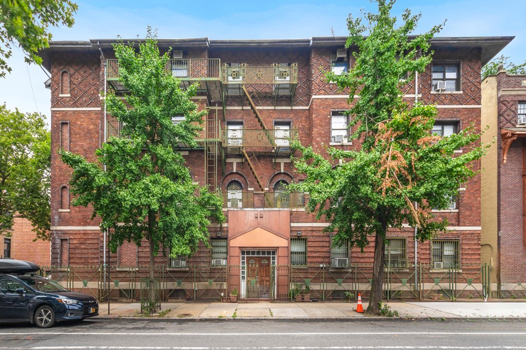

This Property Is For Sale
NEARBY LISTINGS FOR SALE OR LEASE
Property Detail
225 Brooklyn Ave
01250-0009
Kings
Governmentalpublicusegeneral
New York
X
9
3604970212F
0.07 AC
0
North Brooklyn
2024
Long Island (New York)
033900
New York-Jersey City-White Plains, NY-NJ
11,460 SF
DEMOGRAPHICS near 225 Brooklyn Ave
1 Mile
3 Mile
5 Mile
2024 Total Population
191,557
1,338,830
2,680,021
2029 Population
182,785
1,272,871
2,500,791
Pop Growth 2024-2029
(4.58%)
(4.93%)
(6.69%)
Average Age
38
38
39
2024 Total Households
75,738
508,746
1,012,879
HH Growth 2024-2029
(5.24%)
(5.45%)
(6.95%)
Median Household Inc
$68,653
$71,799
$73,910
Avg Household Size
2.40
2.50
2.50
2024 Avg HH Vehicles
.00
.00
1.00
Median Home Value
$1,006,676
$882,160
$849,280
Median Year Built
1947
1948
1948
Nearby Places
- Restaurants
- Banks
- Shops
- Fitness
- Groceries
PUBLIC TRANSPORTATION
TRANSIT/SUBWAY
Kingston Avenue (3 - New York MTA Subway (The Subway), 4 - New York MTA Subway (The Subway))
DRIVE
WALK
Distance
Kingston Avenue (3 - New York MTA Subway (The Subway), 4 - New York MTA Subway (The Subway))
1 min
6 min
0.3 mi
Nostrand Avenue (3,4 Line) (3 - New York MTA Subway (The Subway), 4 - New York MTA Subway (The Subway))
DRIVE
WALK
Distance
Nostrand Avenue (3,4 Line) (3 - New York MTA Subway (The Subway), 4 - New York MTA Subway (The Subway))
1 min
9 min
0.5 mi
President Street (2 - New York MTA Subway (The Subway), 5 - New York MTA Subway (The Subway))
DRIVE
WALK
Distance
President Street (2 - New York MTA Subway (The Subway), 5 - New York MTA Subway (The Subway))
2 min
11 min
0.6 mi
Kingston-Throop Avenues (A - New York MTA Subway (The Subway), C - New York MTA Subway (The Subway))
DRIVE
WALK
Distance
Kingston-Throop Avenues (A - New York MTA Subway (The Subway), C - New York MTA Subway (The Subway))
3 min
13 min
0.7 mi
Nostrand Avenue (A,C Line) (A - New York MTA Subway (The Subway), C - New York MTA Subway (The Subway))
DRIVE
WALK
Distance
Nostrand Avenue (A,C Line) (A - New York MTA Subway (The Subway), C - New York MTA Subway (The Subway))
3 min
16 min
0.8 mi
COMMUTER RAIL
Nostrand Avenue Station (Far Rockaway Branch - Long Island Rail Road, Hempstead Branch - Long Island Rail Road, Long Beach Branch - Long Island Rail Road, West Hempstead Branch - Long Island Rail Road)
DRIVE
WALK
Distance
Nostrand Avenue Station (Far Rockaway Branch - Long Island Rail Road, Hempstead Branch - Long Island Rail Road, Long Beach Branch - Long Island Rail Road, West Hempstead Branch - Long Island Rail Road)
4 min
12 min
0.7 mi
Atlantic Terminal (Babylon Branch - Long Island Rail Road, City Terminal Zone - Long Island Rail Road, Hempstead Branch - Long Island Rail Road, West Hempstead Branch - Long Island Rail Road)
DRIVE
WALK
Distance
Atlantic Terminal (Babylon Branch - Long Island Rail Road, City Terminal Zone - Long Island Rail Road, Hempstead Branch - Long Island Rail Road, West Hempstead Branch - Long Island Rail Road)
7 min
2.2 mi
AIRPORT
Laguardia
DRIVE
WALK
Distance
Laguardia
23 min
11.2 mi
John F Kennedy International
DRIVE
WALK
Distance
John F Kennedy International
20 min
11.6 mi
Newark Liberty International
DRIVE
WALK
Distance
Newark Liberty International
32 min
17.5 mi
Freight Ports
NY - Red Hook Container Terminal
DRIVE
WALK
Distance
NY - Red Hook Container Terminal
12 min
4.7 mi
Nearby Properties
Address
Land Use
TOTAL SIZE
Lot Size
Zoning
Address
Land Use
TOTAL SIZE
Lot Size
Zoning
2,812,739 SF
2.10 AC
C5-3
Address
Land Use
TOTAL SIZE
Lot Size
Zoning
92,440 SF
466.23 AC
R5
Address
Land Use
TOTAL SIZE
Lot Size
Zoning
1,503,150 SF
20.47 AC
R5
Address
Land Use
TOTAL SIZE
Lot Size
Zoning
393.54 AC
PARK
Address
Land Use
TOTAL SIZE
Lot Size
Zoning
577,381 SF
3.19 AC
R6
Address
Land Use
TOTAL SIZE
Lot Size
Zoning
942,992 SF
2.22 AC
R7-1
Address
Land Use
TOTAL SIZE
Lot Size
Zoning
1,330,743 SF
2.20 AC
C6-4
Address
Land Use
TOTAL SIZE
Lot Size
Zoning
296,915 SF
0.31 AC
C5-3
Address
Land Use
TOTAL SIZE
Lot Size
Zoning
830,879 SF
1 AC
C5-4
Address
Land Use
TOTAL SIZE
Lot Size
Zoning
835,231 SF
11.32 AC
R6
Address
Land Use
TOTAL SIZE
Lot Size
Zoning
1,061,228 SF
8.86 AC
R5
Address
Land Use
TOTAL SIZE
Lot Size
Zoning
579,404 SF
11.20 AC
R6
Address
Land Use
TOTAL SIZE
Lot Size
Zoning
1,073,920 SF
16.53 AC
R6
Address
Land Use
TOTAL SIZE
Lot Size
Zoning
790,392 SF
0.74 AC
M1-1
Address
Land Use
TOTAL SIZE
Lot Size
Zoning
561,945 SF
11.58 AC
R6
Address
Land Use
TOTAL SIZE
Lot Size
Zoning
662,532 SF
1.21 AC
C6-4
Address
Land Use
TOTAL SIZE
Lot Size
Zoning
978,544 SF
1.60 AC
C61A
Address
Land Use
TOTAL SIZE
Lot Size
Zoning
370,363 SF
0.34 AC
C6-4
Address
Land Use
TOTAL SIZE
Lot Size
Zoning
785,450 SF
14.22 AC
R6
Address
Land Use
TOTAL SIZE
Lot Size
Zoning
667,250 SF
1.06 AC
C64.5
Address
Land Use
TOTAL SIZE
Lot Size
Zoning
629,064 SF
0.99 AC
C6-4
Address
Land Use
TOTAL SIZE
Lot Size
Zoning
472,115 SF
0.49 AC
C64.5
Address
Land Use
TOTAL SIZE
Lot Size
Zoning
450,516 SF
2.32 AC
C6-4
Address
Land Use
TOTAL SIZE
Lot Size
Zoning
725,991 SF
1.05 AC
C6-4
Address
Land Use
TOTAL SIZE
Lot Size
Zoning
600,000 SF
2.51 AC
R6B
Address
Land Use
TOTAL SIZE
Lot Size
Zoning
566,000 SF
12.33 AC
R6
Address
Land Use
TOTAL SIZE
Lot Size
Zoning
370,789 SF
0.45 AC
R6B
Address
Land Use
TOTAL SIZE
Lot Size
Zoning
767,750 SF
3.78 AC
C6-4
Address
Land Use
TOTAL SIZE
Lot Size
Zoning
304,080 SF
5.17 AC
M1-2
Address
Land Use
TOTAL SIZE
Lot Size
Zoning
389,125 SF
3.48 AC
C6-4
The World's #1 Commercial Real Estate Marketplace
Connect with us
© 2025 CoStar Group
The information above has been obtained from sources believed reliable. While we do not doubt its accuracy we have not verified it and make no guarantee, warranty or representation about it. It is your responsibility to independently confirm its accuracy and completeness. Any projections, opinions, assumptions, or estimates used are for example only and do not represent the current or future performance of the property. The value of this transaction to you depends on tax and other factors which should be evaluated by your tax, financial, and legal advisors. You and your advisors should conduct a careful, independent investigation of the property to determine to your satisfaction the suitability of the property for your needs.