Property Record
22501 Chase, Aliso Viejo, CA 92656


NEARBY LISTINGS FOR SALE OR LEASE
-
-
View all Aliso Viejo listings for sale on LoopNet.com
Property Detail
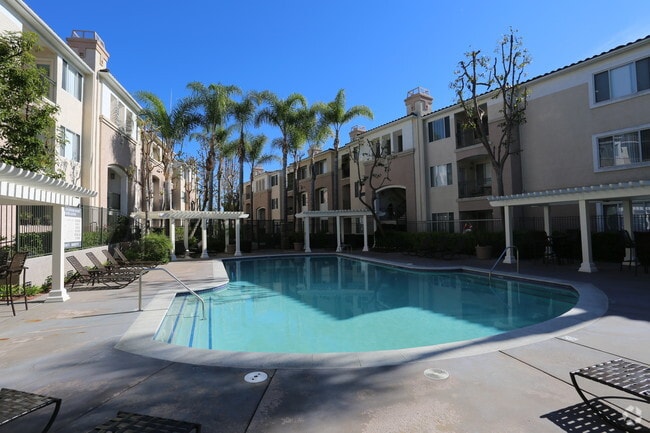
22501 Chase
Anaheim-Santa Ana-Irvine, CA
N TR 13960 BLK LOT 1 TRACT 13960 LOT 1 POR OF LOT & POR OF LOT A
629-132-01
Orange
Multifamilydwelling
California
X
1,a
06059C0428J
15.53 AC
2024
South County
2025
Orange County (California)
062638
DEMOGRAPHICS near 22501 Chase
1 Mile
3 Mile
5 Mile
2024 Total Population
20,104
104,499
249,999
2029 Population
19,714
103,658
248,024
Pop Growth 2024-2029
(1.94%)
(0.80%)
(0.79%)
Average Age
37
47
45
2024 Total Households
7,290
44,776
100,210
HH Growth 2024-2029
(2.11%)
(0.59%)
(0.58%)
Median Household Inc
$139,601
$98,536
$110,938
Avg Household Size
2.70
2.30
2.40
2024 Avg HH Vehicles
2.00
2.00
2.00
Median Home Value
$867,362
$687,545
$817,938
Median Year Built
1995
1985
1981
Nearby Places
Map Layers
Map Styles
 Street
 Aerial
- Restaurants
- Banks
- Shops
- Fitness
- Groceries
PUBLIC TRANSPORTATION
COMMUTER RAIL
Laguna Niguel/Mission Viejo (Inland Empire-Orange County Line - Southern California Regional Rail Authority (Metrolink), Orange County Line - Southern California Regional Rail Authority (Metrolink))
DRIVE
WALK
Distance
Laguna Niguel/Mission Viejo (Inland Empire-Orange County Line - Southern California Regional Rail Authority (Metrolink), Orange County Line - Southern California Regional Rail Authority (Metrolink))
13 min
6.6 mi
Irvine (Inland Empire-Orange County Line - Southern California Regional Rail Authority (Metrolink), Orange County Line - Southern California Regional Rail Authority (Metrolink))
DRIVE
WALK
Distance
Irvine (Inland Empire-Orange County Line - Southern California Regional Rail Authority (Metrolink), Orange County Line - Southern California Regional Rail Authority (Metrolink))
15 min
9.5 mi
AIRPORT
John Wayne/Orange County
DRIVE
WALK
Distance
John Wayne/Orange County
18 min
13.5 mi
Long Beach (Daugherty Field)
DRIVE
WALK
Distance
Long Beach (Daugherty Field)
40 min
33.5 mi
Freight Ports
Port of Long Beach
DRIVE
WALK
Distance
Port of Long Beach
45 min
33.1 mi
Nearby Properties
Address
Land Use
TOTAL SIZE
Lot Size
Zoning
Address
Land Use
TOTAL SIZE
Lot Size
Zoning
609,840 SF
28.33 AC
Address
Land Use
TOTAL SIZE
Lot Size
Zoning
Address
Land Use
TOTAL SIZE
Lot Size
Zoning
602,904 SF
22.10 AC
Address
Land Use
TOTAL SIZE
Lot Size
Zoning
Address
Land Use
TOTAL SIZE
Lot Size
Zoning
8.26 AC
Address
Land Use
TOTAL SIZE
Lot Size
Zoning
Address
Land Use
TOTAL SIZE
Lot Size
Zoning
Address
Land Use
TOTAL SIZE
Lot Size
Zoning
28,700 SF
3.35 AC
Address
Land Use
TOTAL SIZE
Lot Size
Zoning
133,600 SF
2.62 AC
Address
Land Use
TOTAL SIZE
Lot Size
Zoning
Address
Land Use
TOTAL SIZE
Lot Size
Zoning
9.18 AC
Address
Land Use
TOTAL SIZE
Lot Size
Zoning
Address
Land Use
TOTAL SIZE
Lot Size
Zoning
Address
Land Use
TOTAL SIZE
Lot Size
Zoning
5.13 AC
Address
Land Use
TOTAL SIZE
Lot Size
Zoning
2.81 AC
Address
Land Use
TOTAL SIZE
Lot Size
Zoning
165,662 SF
8.60 AC
Address
Land Use
TOTAL SIZE
Lot Size
Zoning
245,482 SF
19.72 AC
Address
Land Use
TOTAL SIZE
Lot Size
Zoning
267,463 SF
19.51 AC
Address
Land Use
TOTAL SIZE
Lot Size
Zoning
2.31 AC
Address
Land Use
TOTAL SIZE
Lot Size
Zoning
Address
Land Use
TOTAL SIZE
Lot Size
Zoning
7.27 AC
Address
Land Use
TOTAL SIZE
Lot Size
Zoning
Address
Land Use
TOTAL SIZE
Lot Size
Zoning
157,676 SF
12.23 AC
Address
Land Use
TOTAL SIZE
Lot Size
Zoning
123,057 SF
7.45 AC
Address
Land Use
TOTAL SIZE
Lot Size
Zoning
76.25 AC
Address
Land Use
TOTAL SIZE
Lot Size
Zoning
210,765 SF
16.01 AC
Address
Land Use
TOTAL SIZE
Lot Size
Zoning
5.20 AC
Address
Land Use
TOTAL SIZE
Lot Size
Zoning
Address
Land Use
TOTAL SIZE
Lot Size
Zoning
176,449 SF
15.43 AC
The World's #1 Commercial Real Estate Marketplace
Connect with us
© 2025 CoStar Group
The information above has been obtained from sources believed reliable. While we do not doubt its accuracy we have not verified it and make no guarantee, warranty or representation about it. It is your responsibility to independently confirm its accuracy and completeness. Any projections, opinions, assumptions, or estimates used are for example only and do not represent the current or future performance of the property. The value of this transaction to you depends on tax and other factors which should be evaluated by your tax, financial, and legal advisors. You and your advisors should conduct a careful, independent investigation of the property to determine to your satisfaction the suitability of the property for your needs.