Property Record
2254 State Route 5, Utica, NY 13502


NEARBY LISTINGS FOR SALE OR LEASE
-
-
View all Utica listings for lease on LoopNet.com
Property Detail
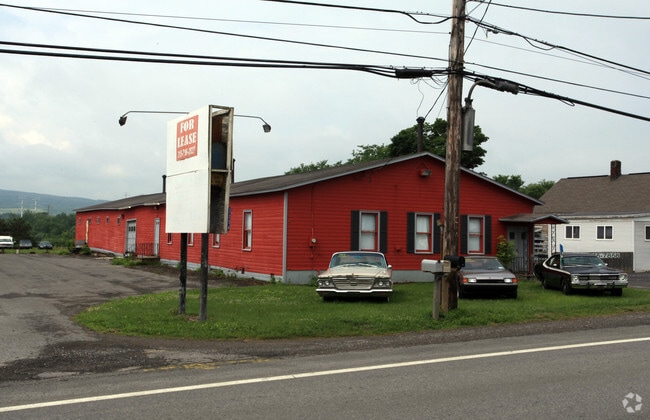
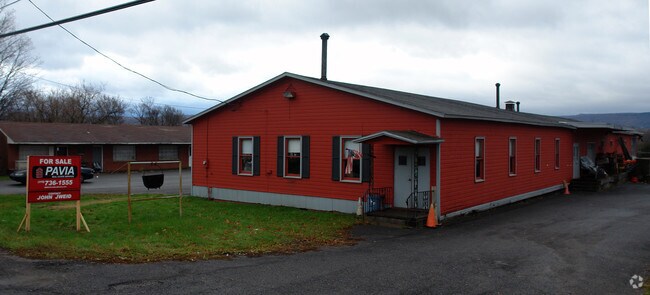
2254 State Route 5
Utica-Rome, NY
S 1008 BLDG & HOUSE 10 1 STATE
214800-104-011-0001-024-000-0000
Herkimer
Warehouse
New York
2025
24.000
2024
0.86 AC
011302
South Herkimer County
6,000 SF
Utica/Rome
DEMOGRAPHICS near 2254 State Route 5
1 Mile
3 Mile
5 Mile
2024 Total Population
1,056
14,389
55,570
2029 Population
1,041
14,060
54,352
Pop Growth 2024-2029
(1.42%)
(2.29%)
(2.19%)
Average Age
49
42
39
2024 Total Households
534
5,830
21,950
HH Growth 2024-2029
(1.50%)
(2.30%)
(2.09%)
Median Household Inc
$40,031
$49,280
$43,437
Avg Household Size
2.00
2.30
2.40
2024 Avg HH Vehicles
1.00
2.00
1.00
Median Home Value
$85,497
$131,180
$138,356
Median Year Built
1984
1959
1950
Nearby Places
Map Layers
Map Styles
 Street
 Aerial
- Restaurants
- Banks
- Shops
- Fitness
- Groceries
PUBLIC TRANSPORTATION
COMMUTER RAIL
Utica Amtrak Station (Empire Service - Amtrak, Lake Shore Limited - Amtrak, Maple Leaf - Amtrak)
DRIVE
WALK
Distance
Utica Amtrak Station (Empire Service - Amtrak, Lake Shore Limited - Amtrak, Maple Leaf - Amtrak)
7 min
4.5 mi
Utica (Toronto - New York - VIA Rail)
DRIVE
WALK
Distance
Utica (Toronto - New York - VIA Rail)
7 min
4.6 mi
Freight Ports
Albany, NY Port
DRIVE
WALK
Distance
Albany, NY Port
112 min
91.3 mi
SALE & LEASE HISTORY
LISTING DATE
SALE/LEASE

Sep 25, 2016
For Lease
Nearby Properties
Address
Land Use
TOTAL SIZE
Lot Size
Zoning
Address
Land Use
TOTAL SIZE
Lot Size
Zoning
1 AC
RA
Address
Land Use
TOTAL SIZE
Lot Size
Zoning
148,962 SF
31.10 AC
Address
Land Use
TOTAL SIZE
Lot Size
Zoning
195,000 SF
49.40 AC
CH
Address
Land Use
TOTAL SIZE
Lot Size
Zoning
61,000 SF
9.90 AC
CH
Address
Land Use
TOTAL SIZE
Lot Size
Zoning
61,940 SF
5.31 AC
Address
Land Use
TOTAL SIZE
Lot Size
Zoning
120,484 SF
11.20 AC
Address
Land Use
TOTAL SIZE
Lot Size
Zoning
50,000 SF
11.50 AC
CH
Address
Land Use
TOTAL SIZE
Lot Size
Zoning
371,680 SF
21.81 AC
Address
Land Use
TOTAL SIZE
Lot Size
Zoning
106,875 SF
17.80 AC
Address
Land Use
TOTAL SIZE
Lot Size
Zoning
141,072 SF
18.70 AC
Address
Land Use
TOTAL SIZE
Lot Size
Zoning
14.30 AC
RA
Address
Land Use
TOTAL SIZE
Lot Size
Zoning
16,502 SF
4.76 AC
CH
Address
Land Use
TOTAL SIZE
Lot Size
Zoning
1,080 SF
43.30 AC
CH
Address
Land Use
TOTAL SIZE
Lot Size
Zoning
1,456 SF
30 AC
PD
Address
Land Use
TOTAL SIZE
Lot Size
Zoning
131.40 AC
Address
Land Use
TOTAL SIZE
Lot Size
Zoning
138,950 SF
14.60 AC
R
Address
Land Use
TOTAL SIZE
Lot Size
Zoning
34,304 SF
9.40 AC
Address
Land Use
TOTAL SIZE
Lot Size
Zoning
55,310 SF
57.15 AC
Address
Land Use
TOTAL SIZE
Lot Size
Zoning
184,128 SF
13.30 AC
Address
Land Use
TOTAL SIZE
Lot Size
Zoning
45,143 SF
2.10 AC
Address
Land Use
TOTAL SIZE
Lot Size
Zoning
87,000 SF
4.30 AC
Address
Land Use
TOTAL SIZE
Lot Size
Zoning
117,260 SF
11.50 AC
CH
Address
Land Use
TOTAL SIZE
Lot Size
Zoning
50,208 SF
12.46 AC
Address
Land Use
TOTAL SIZE
Lot Size
Zoning
768 SF
10 AC
CH
Address
Land Use
TOTAL SIZE
Lot Size
Zoning
465,682 SF
10.60 AC
R
Address
Land Use
TOTAL SIZE
Lot Size
Zoning
28,400 SF
11.38 AC
Address
Land Use
TOTAL SIZE
Lot Size
Zoning
51,257 SF
4.70 AC
Address
Land Use
TOTAL SIZE
Lot Size
Zoning
26,251 SF
8 AC
Address
Land Use
TOTAL SIZE
Lot Size
Zoning
50,138 SF
25 AC
R
Address
Land Use
TOTAL SIZE
Lot Size
Zoning
780 SF
9.60 AC
CH
The World's #1 Commercial Real Estate Marketplace
Connect with us
© 2026 CoStar Group
The information above has been obtained from sources believed reliable. While we do not doubt its accuracy we have not verified it and make no guarantee, warranty or representation about it. It is your responsibility to independently confirm its accuracy and completeness. Any projections, opinions, assumptions, or estimates used are for example only and do not represent the current or future performance of the property. The value of this transaction to you depends on tax and other factors which should be evaluated by your tax, financial, and legal advisors. You and your advisors should conduct a careful, independent investigation of the property to determine to your satisfaction the suitability of the property for your needs.