Property Record
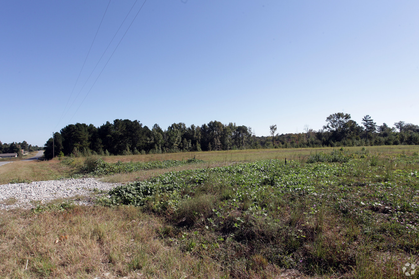
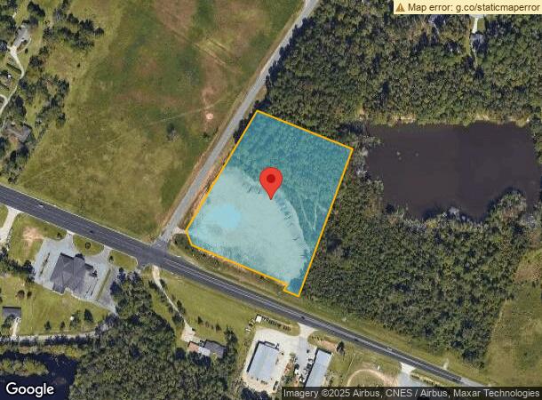
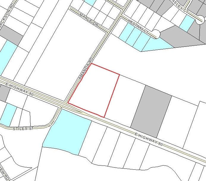
22738 Us Highway 80 E, Statesboro, GA 30461
NEARBY LISTINGS FOR SALE OR LEASE
Property Detail
22738 Us Highway 80 E
Statesboro, GA
Millstone
107-000023-014
LT 7 /5.83 AC
Commercialnec
Bulloch
X
Georgia
13031C0240D
7
2024
5.83 AC
2024
Georgia South Area
110603
Other Market Areas
6,000 SF
DEMOGRAPHICS near 22738 Us Highway 80 E
1 Mile
3 Mile
5 Mile
2024 Total Population
1,729
23,660
48,833
2029 Population
1,914
25,784
53,243
Pop Growth 2024-2029
+ 10.70%
+ 8.98%
+ 9.03%
Average Age
41
32
32
2024 Total Households
743
8,835
18,084
HH Growth 2024-2029
+ 11.17%
+ 9.85%
+ 9.83%
Median Household Inc
$78,184
$49,078
$49,545
Avg Household Size
2.30
2.30
2.40
2024 Avg HH Vehicles
2.00
2.00
2.00
Median Home Value
$252,011
$189,936
$184,924
Median Year Built
1997
1991
1992
Nearby Places
- Restaurants
- Banks
- Shops
- Fitness
- Groceries
SALE & LEASE HISTORY
LISTING DATE
SALE/LEASE

Sep 24, 2016
For Sale
Jun 14, 2017
For Sale
Nearby Properties
Address
Land Use
TOTAL SIZE
Lot Size
Zoning
Address
Land Use
TOTAL SIZE
Lot Size
Zoning
250,037 SF
30.67 AC
O
Address
Land Use
TOTAL SIZE
Lot Size
Zoning
9,870 SF
46.47 AC
CR/R4
Address
Land Use
TOTAL SIZE
Lot Size
Zoning
7,063 SF
22.96 AC
R4
Address
Land Use
TOTAL SIZE
Lot Size
Zoning
5.54 AC
EXPT
Address
Land Use
TOTAL SIZE
Lot Size
Zoning
41.09 AC
R3/R15
Address
Land Use
TOTAL SIZE
Lot Size
Zoning
3,659 SF
38.60 AC
R40
Address
Land Use
TOTAL SIZE
Lot Size
Zoning
3,951 SF
20.19 AC
CR
Address
Land Use
TOTAL SIZE
Lot Size
Zoning
950 SF
12.73 AC
PUD/R4
Address
Land Use
TOTAL SIZE
Lot Size
Zoning
4,622 SF
17 AC
R4/CR
Address
Land Use
TOTAL SIZE
Lot Size
Zoning
22,392 SF
13.97 AC
R4
Address
Land Use
TOTAL SIZE
Lot Size
Zoning
102,529 SF
18.07 AC
CR
Address
Land Use
TOTAL SIZE
Lot Size
Zoning
3,552 SF
16.42 AC
PUD/R4/CR
Address
Land Use
TOTAL SIZE
Lot Size
Zoning
4,450 SF
26.60 AC
R4
Address
Land Use
TOTAL SIZE
Lot Size
Zoning
190,382 SF
23.53 AC
CR
Address
Land Use
TOTAL SIZE
Lot Size
Zoning
153.74 AC
R40
Address
Land Use
TOTAL SIZE
Lot Size
Zoning
8,394 SF
14.34 AC
R4/CR
Address
Land Use
TOTAL SIZE
Lot Size
Zoning
4,969 SF
13.52 AC
PUD/R4
Address
Land Use
TOTAL SIZE
Lot Size
Zoning
1,893 SF
10.73 AC
R4
Address
Land Use
TOTAL SIZE
Lot Size
Zoning
76,118 SF
12.31 AC
CR
Address
Land Use
TOTAL SIZE
Lot Size
Zoning
20.77 AC
R15
Address
Land Use
TOTAL SIZE
Lot Size
Zoning
3,288 SF
18.48 AC
R4
Address
Land Use
TOTAL SIZE
Lot Size
Zoning
1,668 SF
14.51 AC
R4
Address
Land Use
TOTAL SIZE
Lot Size
Zoning
83,803 SF
14.40 AC
CR
Address
Land Use
TOTAL SIZE
Lot Size
Zoning
61,539 SF
2.50 AC
CR
Address
Land Use
TOTAL SIZE
Lot Size
Zoning
64,614 SF
Address
Land Use
TOTAL SIZE
Lot Size
Zoning
64,350 SF
3.31 AC
PUD/CR
Address
Land Use
TOTAL SIZE
Lot Size
Zoning
4,248 SF
19.24 AC
R40
Address
Land Use
TOTAL SIZE
Lot Size
Zoning
3,773 SF
6.90 AC
CR
Address
Land Use
TOTAL SIZE
Lot Size
Zoning
42,149 SF
5.61 AC
CR
Address
Land Use
TOTAL SIZE
Lot Size
Zoning
54,062 SF
2.20 AC
CR
The World's #1 Commercial Real Estate Marketplace
Connect with us
© 2025 CoStar Group
The information above has been obtained from sources believed reliable. While we do not doubt its accuracy we have not verified it and make no guarantee, warranty or representation about it. It is your responsibility to independently confirm its accuracy and completeness. Any projections, opinions, assumptions, or estimates used are for example only and do not represent the current or future performance of the property. The value of this transaction to you depends on tax and other factors which should be evaluated by your tax, financial, and legal advisors. You and your advisors should conduct a careful, independent investigation of the property to determine to your satisfaction the suitability of the property for your needs.