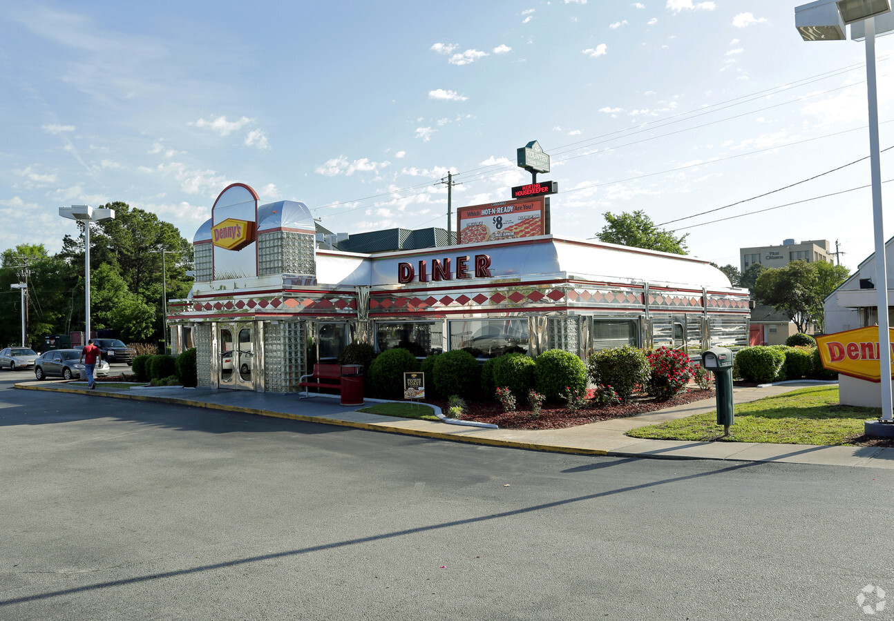
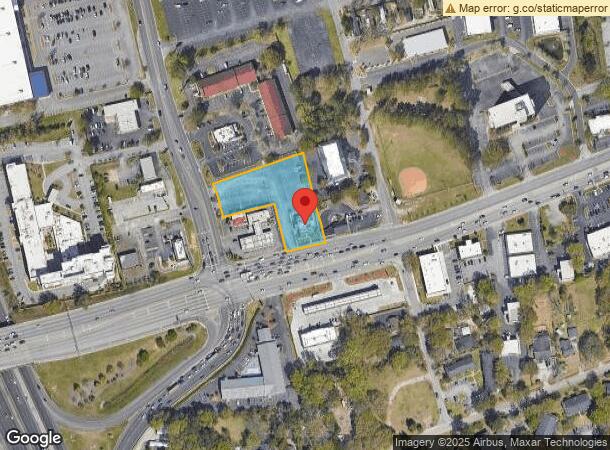
Property Record
2280 Ashley Phosphate Rd, North Charleston, SC 29406
NEARBY LISTINGS FOR SALE OR LEASE
Property Detail
2280 Ashley Phosphate Rd
484-11-00-030
LEGAL DESCRIPTION MAPPLATB S16 MAPPLATP 0244 SUBDIVISIONNAME NORTH CHARLESTON TRACT PRT OF TRACT B UNIT 10
Restaurantbuilding
Charleston
X
South Carolina
45019C0295K
1.38 AC
2024
North Charleston
2023
Charleston/N Charleston
003104
Charleston-North Charleston, SC
2,890 SF
DEMOGRAPHICS near 2280 Ashley Phosphate Rd
1 Mile
3 Mile
5 Mile
2024 Total Population
8,541
58,941
143,380
2029 Population
9,099
65,096
158,393
Pop Growth 2024-2029
+ 6.53%
+ 10.44%
+ 10.47%
Average Age
35
36
37
2024 Total Households
3,406
22,916
55,324
HH Growth 2024-2029
+ 6.22%
+ 10.26%
+ 10.28%
Median Household Inc
$40,078
$58,480
$61,119
Avg Household Size
2.40
2.50
2.50
2024 Avg HH Vehicles
2.00
2.00
2.00
Median Home Value
$195,108
$226,373
$229,275
Median Year Built
1984
1989
1991
Nearby Places
- Restaurants
- Banks
- Shops
- Fitness
- Groceries
PUBLIC TRANSPORTATION
COMMUTER RAIL
Charleston Amtrak Station (Palmetto - Amtrak, Silver Meteor - Amtrak)
DRIVE
WALK
Distance
Charleston Amtrak Station (Palmetto - Amtrak, Silver Meteor - Amtrak)
8 min
5.6 mi
AIRPORT
Charleston AFB/International
DRIVE
WALK
Distance
Charleston AFB/International
13 min
6.2 mi
Freight Ports
North Charleston Terminal
DRIVE
WALK
Distance
North Charleston Terminal
8 min
5.2 mi
SALE & LEASE HISTORY
LISTING DATE
SALE/LEASE

May 12, 2023
For Sale
Nearby Properties
Address
Land Use
TOTAL SIZE
Lot Size
Zoning
Address
Land Use
TOTAL SIZE
Lot Size
Zoning
Address
Land Use
TOTAL SIZE
Lot Size
Zoning
10,172 SF
12.76 AC
Address
Land Use
TOTAL SIZE
Lot Size
Zoning
7,200 SF
8.73 AC
Address
Land Use
TOTAL SIZE
Lot Size
Zoning
21,364 SF
7.71 AC
Address
Land Use
TOTAL SIZE
Lot Size
Zoning
101,011 SF
6.58 AC
Address
Land Use
TOTAL SIZE
Lot Size
Zoning
199,300 SF
13.28 AC
Address
Land Use
TOTAL SIZE
Lot Size
Zoning
48,885 SF
5.02 AC
Address
Land Use
TOTAL SIZE
Lot Size
Zoning
126,385 SF
13.45 AC
Address
Land Use
TOTAL SIZE
Lot Size
Zoning
14,725 SF
3.55 AC
Address
Land Use
TOTAL SIZE
Lot Size
Zoning
Address
Land Use
TOTAL SIZE
Lot Size
Zoning
9,691 SF
10.34 AC
Address
Land Use
TOTAL SIZE
Lot Size
Zoning
48,400 SF
5.76 AC
Address
Land Use
TOTAL SIZE
Lot Size
Zoning
167,100 SF
8 AC
Address
Land Use
TOTAL SIZE
Lot Size
Zoning
58,444 SF
5.61 AC
Address
Land Use
TOTAL SIZE
Lot Size
Zoning
33.88 AC
Address
Land Use
TOTAL SIZE
Lot Size
Zoning
169,262 SF
14.87 AC
Address
Land Use
TOTAL SIZE
Lot Size
Zoning
Address
Land Use
TOTAL SIZE
Lot Size
Zoning
44,300 SF
2.34 AC
Address
Land Use
TOTAL SIZE
Lot Size
Zoning
293,825 SF
30.43 AC
Address
Land Use
TOTAL SIZE
Lot Size
Zoning
22,246 SF
5.25 AC
Address
Land Use
TOTAL SIZE
Lot Size
Zoning
1.26 AC
Address
Land Use
TOTAL SIZE
Lot Size
Zoning
13,012 SF
1.40 AC
Address
Land Use
TOTAL SIZE
Lot Size
Zoning
16,000 SF
2.61 AC
Address
Land Use
TOTAL SIZE
Lot Size
Zoning
5,400 SF
5.86 AC
Address
Land Use
TOTAL SIZE
Lot Size
Zoning
13,696 SF
25.08 AC
BERKELEY C
Address
Land Use
TOTAL SIZE
Lot Size
Zoning
105,600 SF
7.22 AC
Address
Land Use
TOTAL SIZE
Lot Size
Zoning
Address
Land Use
TOTAL SIZE
Lot Size
Zoning
9,967 SF
1.74 AC
Address
Land Use
TOTAL SIZE
Lot Size
Zoning
Address
Land Use
TOTAL SIZE
Lot Size
Zoning
11.58 AC
The World's #1 Commercial Real Estate Marketplace
Connect with us
© 2025 CoStar Group
The information above has been obtained from sources believed reliable. While we do not doubt its accuracy we have not verified it and make no guarantee, warranty or representation about it. It is your responsibility to independently confirm its accuracy and completeness. Any projections, opinions, assumptions, or estimates used are for example only and do not represent the current or future performance of the property. The value of this transaction to you depends on tax and other factors which should be evaluated by your tax, financial, and legal advisors. You and your advisors should conduct a careful, independent investigation of the property to determine to your satisfaction the suitability of the property for your needs.